United States
›
California
›
Los Padres National Forest

Best Hiking Trails in Los Padres National Forest

500 reviews


link Copy Link email Email directions Driving Directions

Seasonal Popularity

Overview

Los Padres National Forest is a national forest in California.


Resources

  • fs.usda.gov
  • wikipedia

  • Hiking Trails (514)
  • Reviews (500)
  1. 1
    Willet Hot Spring via Sespe River Trail
    ★ ★ ★ ★ ★ DIFFICULT 10.0 mi
  2. 2
    Pine Valley via Pine Ridge Trail and Church Creek Trail
    ★ ★ ★ ★ ★ MODERATE 5.4 mi
  3. 3
    Espinosa Camp via Vincente Flat Trail
    ★ ★ ★ ★ ★ DIFFICULT 5.0 mi
  4. 4
    Little Sur Camp via Camp Road
    ★ ★ ★ ★ ★ MODERATE 3.5 mi
  5. 5
    Arroyo Seco Road
    ★ ★ ★ ★ ★ MODERATE 5.6 mi
  6. 6
    Cone Peak
    ★ ★ ★ ★ ★ MODERATE 2.2 mi
  7. 7
    Silver Camp Loop via Salmon Creek Trail and Cruickshank Trail
    ★ ★ ★ ★ ★ DIFFICULT 15.1 mi
  8. 8
    Mount Carmel Loop via Skinner Ridge Trail
    ★ ★ ★ ★ ★ DIFFICULT 8.5 mi
  9. 9
    Happy Hunting Ground Campground Loop via Manzana Trail and Lost Valley Trail
    ★ ★ ★ ★ ★ DIFFICULT 24.3 mi
  10. 10
    Divide Camp via Pine Ridge Trail
    ★ ★ ★ ★ ★ MODERATE 5.7 mi
    user_profile
    Adam 6 days, 1 hour ago
    Sespe Hot Springs Backpacking
    I needed to get sandals, and my feet are sore and blistered, but man this was so much fun.
    ★ ★ ★ ★

    user_profile
    FunnyCanoe4191 1 week, 6 days ago
    Vincente Flat Trail to Kirk Creek
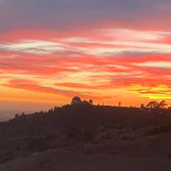
    One of the best hikes into Ventana Wilderness from Highway one. This one has it all: sweeping coastal views, birds, and other wildlife, wildflowers in season. An added bonus is a virgin wood tree at Vincent’s flat.
    ★ ★ ★ ★ ★

    user_profile
    jmt5220 1 month, 1 week ago
    Santa Barbara canyon madulce trail
    Easy wilderness trail
    ★ ★ ★ ★ ★

    user_profile
    wmml3 2 months ago
    Bike hike Cuesta Ridge
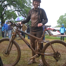
    I biked this road trail up to the tv towers. I was on a hybrid city bike NOT a gravel bike. Most of the road is highly rutted dirt and a steep uphill climb. Nice views. The ride down was difficult had to use brakes most of the way. There are better trails in the area.
    ★ ★

    user_profile
    Julien Brower 2 months, 2 weeks ago
    Willet Hot Spring via Sespe River Trail
    Fun
    ★ ★ ★ ★

    user_profile
    Matthew Nelson 7 months, 1 week ago
    Sunday Morning Activity
    This is a great trail. Easy going and beautiful. A great day trip with a picnic on top of the mountain.
    ★ ★ ★ ★ ★

    user_profile
    Jon Franks 10 months, 1 week ago
    Silver Camp Loop via Salmon Creek Trail and Cruickshank Trail
    A friend and I backpacked this loop starting from the Cruickshank trailhead in 2 nights, it was relatively easy and I would certainly do it again. The portion of the Cruikshank trail from hwy 1 to the loop is pretty overgrown in some spots and the main loop has a few areas of overgrowth but not the worst I’ve seen and it’s passable. The perennial water sources are mostly low strength but every camp has a viable source. The salmon creek falls are accessible and a great place to stop and swim. Overall a good trail with everything you need for a good backpacking trip.
    ★ ★ ★ ★

    user_profile
    Jon Franks 10 months, 1 week ago
    46.0 via Pine Ridge Trail
    This is a really nice hike, the views are great and compared to some of the trails in the area it’s not too difficult, the elevation is not too bad and it’s for the most part it’s a wilderness highway. I backpacked it with some friends and as beginners we shouldn’t have done the 10 miles to Sykes in one day because after 8 miles we were feeling exhausted. Overall great experience and would hike or backpack again.
    ★ ★ ★ ★

    user_profile
    Michelle Dolan 1 year ago
    Sand Dollar Beach and Cliff hike
    Beautiful views, wild flowers, birds, grasses, some bush wacking,
    ★ ★ ★ ★ ★

    user_profile
    DougsRV 1 year, 3 months ago
    Cero Alto Trail Loop
    Nice easy trail with sweeping views of Morro Rock and San Luis Obispo. May have bikers and Dogs on the trail. Trail is maintained and parking areas(s) have pit toilets. Fee to park.
    ★ ★ ★ ★ ★

    user_profile
    DougsRV 1 year, 3 months ago
    Cero Alto Trail Loop
    Nice easy trail with sweeping views of Morro Rock and San Luis Obispo. May have bikers and Dogs on the trail. Trail is maintained and parking areas(s) have pit toilets. Fee to park.
    ★ ★ ★ ★ ★

    user_profile
    sustainablesur 1 year, 6 months ago
    Santa Lucia Trail
    After extensive and intense rehabilitation and rescue the restoration of the lower portion of the Santa Lucia trail is,while ongoing it once again is usable and safe. Thanks to the efforts of the @BigSurRecCrew and the donations of their donors. Make sure to check thier efforts and follow the progress on instagram
    ★ ★ ★ ★ ★

    user_profile
    HugeHat2982 1 year, 6 months ago
    Solo Birthday Backpacking to Bear Trap Camp Via Gene Marshal Trail
    Great hike, watch out of the acorns on the trail, super slippery. Being a good sleeping bag when u camp in the valley. Lots of water to fill from.
    ★ ★ ★ ★ ★

    user_profile
    HugeHat2982 1 year, 6 months ago
    Solo Birthday Backpacking to Bear Trap Camp Via Gene Marshal Trail
    Great hike, watch out of the acorns on the trail, super slippery. Being a good sleeping bag when u camp in the valley. Lots of water to fill from.
    ★ ★ ★ ★ ★

    user_profile
    HugeHat2982 1 year, 6 months ago
    Solo Birthday Backpacking to Bear Trap Camp Via Gene Marshal Trail
    Great hike, watch out of the acorns on the trail, super slippery. Being a good sleeping bag when u camp in the valley. Lots of water to fill from.
    ★ ★ ★ ★ ★

    user_profile
    HugeHat2982 1 year, 6 months ago
    Solo Birthday Backpacking to Bear Trap Camp Via Gene Marshal Trail
    Great hike, watch out of the acorns on the trail, super slippery. Being a good sleeping bag when u camp in the valley. Lots of water to fill from.
    ★ ★ ★ ★ ★

    user_profile
    jefeflher 1 year, 7 months ago
    Road to Dough Flat
    North of Fillmore,CA Start at HWY 126 (cross of SR 23). FYI; this is where you grab fuel, food and find a toilet. Head north on “A” St. In about a mile there will be a yield sign, bear right onto Goodenough Rd. At the end of Goodenough, there’s a fork, uphill to the right. Stock 2wd pickups and “soft roaders” are fine on the main road. There’s enough vertical clearance for sprinter vans and plenty of cut-outs to turn around. This is a single lane fire road (6N16.1 and 6N16.2) that passes through Los Padres NF and the California Condor Sanctuary. The first 5 miles or so, there is a mix of Macadam, broken shale and gravel. It’s a bench cut road on a steep hillside with many blind, sometimes slippery turns. This part is susceptible to rockslides. This road is used by employees working in the oilfields. Large trucks can sometimes be excepted. At the 5 mile is a plateau that used to be a USFS station. From here, there is no more asphalt. It’s mostly silt and gravel over hardpack with the occasional hidden boulder in the roadbed. At around mile 7 is the Tar Creek trailhead, which is currently closed. From here on the road gets less maintenance and is susceptible to the weather. Expect to find more ruts and seasonal mud. This area will often close after heavy storms. At the Dough Flat trailhead there is a pit toilet, behind which, the trail into Alder Creek and Sespe Creek starts. This can be either the terminus or start of a through hike of the Sespe Wilderness to Piedras Blancas north of Ojai. The Condor Overlook trail also starts nearby. This is a short in and out hike up a knoll a short walk back on the road you drove in on. As far as 4x4 or adventure biking… this is not a worthwhile trip, unless you want a quick side trip and you’re in the area. However, if you want to do some hiking, it’s worthwhile, especially in spring when it’s green and water is flowing.
    ★ ★ ★

    user_profile
    WarmMtBoots5978 1 year, 7 months ago
    Tassajera Repeater to Cuesta Pass, San Luis Obispo County, CA, USA
    5 star for the views. Beautiful views of PCh corridor and Morro Bay Area.
    ★ ★ ★ ★ ★

    user_profile
    jmt5220 1 year, 8 months ago
    Friday Morning Activity
    See country not many people see. Not easy. Can be dangerously hot or the opposite.
    ★ ★ ★ ★ ★

    user_profile
    SanchezDirty 1 year, 8 months ago
    Salmon creek loop
    Good trail conditions. A few fallen trees but nothing you can’t get through. Poison oak galore. 95% of streams that go through the trail are dried up. Manageable with rationing and filling up between spots.
    ★ ★ ★ ★

    user_profile
    HillyMtBoots7483 1 year, 8 months ago
    Salmon Creek to Lions Den
    The destination camp was amazing but the way up was tough, not really a trail and no good sources of water(had to walk an extra mile to get water). Would love to do this hike again not the way we went up. Would probably go up and down same way.
    ★ ★ ★

    user_profile
    Patrick Morgan 1 year, 11 months ago
    Pinots and Sawmill Peaks - Peak 1 of 6
    Beautiful trail and a beautiful day for it.
    ★ ★ ★ ★ ★

    user_profile
    BoldSky5013 2 years ago
    Lake Piru 5/18/24
    Worst hike ever
    ★ ★ ★ ★ ★

    user_profile
    george 2 years ago
    Frazier Mountain ride
    Great mountain biking for average riders. Nice pine forest through out and some great views sometimes. Even on a Saturday in May, I only encountered 3 other parties, on motorbikes and OHVs.
    ★ ★ ★ ★

    user_profile
    pete 2 years, 1 month ago
    Track (4/24/24, 9:03:33AM)Cerro Alto hike
    Steep, rugged coastal hills east of Morro Bay. Worth it!!!
    ★ ★ ★ ★

    user_profile
    Temecula Dan 2 years, 2 months ago
    Frazier Mountain
    Solo day hiked Thurs 3/14/2024 – More of a road walk than a hike that starts on pavement, transitions to dirt and then snow at the 7500 ft elevation level. Was a great day to do this trek under blue skies with some manageable wind gusts. Since Frazier Mountain Road (Forest Rd 8N04) is closed for the season right now, it’s a nice time to go for anyone not interested in exercising the post-winter “drive up” option. The abandoned lookout tower and radio tower installations on the Frazier summit are interesting sights, making it worth the stroll up. While the stairs to the lookout are long gone, it is possible to scale the platform (tank side) for a nice, panoramic bird’s eye view. Early morning summit gusts were strong and cold enough to switch to heavier gloves, really nipping fingers when taking gloves off for less than a minute at a time. Another highlight of this hike are the spectacular views on the way down, looking across Cuddy Valley towards the towering summits of Mt Pinos, San Emigdio, Antimony and Escapula. This hike would be great for taking a group on an easy hike/stroll through the forest, with or without snow. Logged 13.1 miles/2594 vertical ft with Gaia.
    ★ ★ ★ ★ ★

    user_profile
    Temecula Dan 2 years, 2 months ago
    Frazier Mountain Road
    Solo day hiked Thurs 3/14/2024 – More of a road walk than a hike that starts on pavement, transitions to dirt and then snow at the 7500 ft elevation level. Was a great day to do this trek under blue skies with some manageable wind gusts. Since Frazier Mountain Road (Forest Rd 8N04) is closed for the season right now, it’s a nice time to go for anyone not interested in exercising the post-winter “drive up” option. The abandoned lookout tower and radio tower installations on the Frazier summit are interesting sights, making it worth the stroll up. While the stairs to the lookout are long gone, it is possible to scale the platform (tank side) for a nice, panoramic bird’s eye view. Early morning summit gusts were strong and cold enough to switch to heavier gloves, really nipping fingers when taking gloves off for less than a minute at a time. Another highlight of this hike are the spectacular views on the way down, looking across Cuddy Valley towards the towering summits of Mt Pinos, San Emigdio, Antimony and Escapula. This hike would be great for taking a group on an easy hike/stroll through the forest, with or without snow. Logged 13.1 miles/2594 vertical ft with Gaia.
    ★ ★ ★ ★ ★

    user_profile
    Temecula Dan 2 years, 2 months ago
    Chorro Grande Trail
    Solo day hiked Thurs 3/14/2024 – Highly recommend the Chorro Grande Trail before the heat! Hiked it in the afternoon in sunny but cooler weather after a morning trek up Frazier Mtn. The trail has a nice, classic slope climbing layout that takes you from a start in the chaparral off Hwy 33, through small oak groves via switchbacks and then to a northern finish in the pines at Pine Mountain Road (Forest Road 6N06). The elevation gain on the way up was constant but well distributed over the trail distance. Much thanks to caretakers of this trail who have trimmed back most of the bushy segments and removed the fallen trees. There are several small stream crossings, a few muddy areas and some slightly overgrown grassy segments, all of which can be easily crossed or bypassed. Extended the trek at the northern end by heading east on Pine Mtn Road and then using micro spikes to directly ascend the SW slope of Pine Mountain. Going down Chorro Grande in the late afternoon is gorgeous with the trail heading S-SW under a constant stream of filtered sunlight and several interesting boulder groups easier seen on the descent. Had to take the long way around to this trail from Frazier Mtn on Mil Potrero Hwy since Lockwood Valley was closed to through traffic (mudslide). Hwy 33 still has active reconstruction with several short delays but not too bad. Logged 12.8 miles/3528 vertical ft with Gaia.
    ★ ★ ★ ★ ★

    user_profile
    Temecula Dan 2 years, 2 months ago
    Reyes Peak via Chorro Grande Trail
    Solo day hiked Thurs 3/14/2024 – Highly recommend the Chorro Grande Trail before the heat! Hiked it in the afternoon in sunny but cooler weather after a morning trek up Frazier Mtn. The trail has a nice, classic slope climbing layout that takes you from a start in the chaparral off Hwy 33, through small oak groves via switchbacks and then to a northern finish in the pines at Pine Mountain Road (Forest Road 6N06). The elevation gain on the way up was constant but well distributed over the trail distance. Much thanks to caretakers of this trail who have trimmed back most of the bushy segments and removed the fallen trees. There are several small stream crossings, a few muddy areas and some slightly overgrown grassy segments, all of which can be easily crossed or bypassed. Extended the trek at the northern end by heading east on Pine Mtn Road and then using micro spikes to directly ascend the SW slope of Pine Mountain. Going down Chorro Grande in the late afternoon is gorgeous with the trail heading S-SW under a constant stream of filtered sunlight and several interesting boulder groups easier seen on the descent. Had to take the long way around to this trail from Frazier Mtn on Mil Potrero Hwy since Lockwood Valley was closed to through traffic (mudslide). Hwy 33 still has active reconstruction with several short delays but not too bad. Logged 12.8 miles/3528 vertical ft with Gaia.
    ★ ★ ★ ★ ★

    user_profile
    Temecula Dan 2 years, 2 months ago
    San Emigdio Mountain via Forest Route 9N34
    Solo day hiked Thurs 2/29/2024 – Chose this hike to stay out of the increasing gusts at the higher elevations and it was a gentle one with great views. Started on forest road 9N34 from Mil Potrero Highway heading north and then east to San Emigdio Mountain for a nice sunrise. Next, west on 9N34 to 9N52 and further west to Brush Mtn and Brush Mtn – North peaks. Went up 8 provincial peaks (bus stops/bumps with views) along the way since they’re on the east-west route. Great weather and only a few snow patches left from the last storm. 9N34 is in the best shape of any forest road I’ve been on in the last year which would be a great snowshoe route just for fun after the next snowfall. The only steep part of this route is a short section of 9N52 going out to the Brush Mtn peaks, before and after the Marian Campground area. Forced myself to relax for a much longer than normal lunch break on Brush-North and enjoy the great views out towards Cerro Noroeste, Grouse, Sawmill and Mt Pinos peaks. Some strong winds started coincidentally with my leaving the summit but disappeared shortly after dropping down a bit. Very pleasant hike in a beautiful area that would be perfect for taking a group on an easy hike/stroll through the forest, with or without snow. There is a nice dirt parking area on the north side of the highway, a few hundred yards east of the locked forest road 9N34 gate. Logged 14.1 miles/2546 vertical ft. with Gaia.
    ★ ★ ★ ★ ★

    user_profile
    QuietSage6188 2 years, 3 months ago
    Track (2/17/24, 11:25:02AM)
    Road to Dough Flats was closed down to flood debris. Hiked the creek at the closure point east. Bear and deer sign, no trail, only way through was to hike knee deep in the creek. Not for beginners.
    ★ ★ ★ ★

    user_profile
    FluffyCanoe3500 2 years, 3 months ago
    Cuesta Pass, San Luis Obispo County, CA, USA
    The hike had some nice views of the county. It was one of the highest points around. The views of the Morro’s were a highlight. The road was mostly hard dirt. It was a bit of surprise to me that cars were allowed there. The east side of 101 they are not. There were several transient like encampments on the route. It looks like they are allowed. I think next time I will take the trails from Calpoly going up and avoid the road atmosphere.
    ★ ★ ★

    user_profile
    Temecula Dan 2 years, 5 months ago
    Sawmill Mountain Loop via Vincent Tumamait Trail
    Solo day hiked Fri 12/15/23 – Early start on the Condor Summit/Mt Pinos dirt road to the Mt Pinos summit and then the Condor Observation Site. No register on Pinos, just the survey benchmark and the Edwards range antenna/solar panel array. From here, it was down the Vincent Tumamait Trail into the Chumash Wilderness and up to the spectacular summit cairn on Sawmill Mountain which was a great place to watch the start of a nice sunrise. The north-south-east views from the summit were equally spectacular since it was a clear weather morning. Found a faint use trail that departed the main trail which went south all the way up to the Sawmill West summit which had only views to the south. After getting back to the main trail and heading northwest for a bit, there was a well-defined spur trail that led up to both the Lower Grouse Mtn south summit and the official Grouse Mtn summit which is marked by a branch teepee with the register tucked into its side. It was a long descent from here to the saddle between Cerro Noroeste and Grouse Mtns and then the steep ascent up to Cerro Noroeste Road. While this part makes you work, the trail is nice but with a few tree crossings. Once at the road, there is a short, lesser used gully trail heading west, directly up to the Cerro Noroeste Summit which is much shorter and safer than going up the road. After walking around the summit through the trees and the Campo Alto campground, I found a 6 ft high boulder stack that seemed to be the high point so I climbed it for fun but didn’t find a register before heading back down. Taking the same route back to the Chula Vista trailhead meant a little extra work on the steep ascents that had allowed for the earlier fast descents. Some extra calories and a steady pace made it a pleasant hike back. Took an out and back detour to Sheep Camp on the trip back and found that the Sheep Camp Spring pipe still had a steady trickle of water coming out of it. While I don’t have a dog, this seems like a great trail on which to bring your canine friend. Didn’t see anyone else on the trail during my trip. Highly recommend this trail and it would’ve been nice to camp for a night before the hike instead of the drive in from Temecula but wasn’t an option for me this week. Logged 15.4 miles/3513 vertical ft. with Gaia.
    ★ ★ ★ ★ ★

    user_profile
    Temecula Dan 2 years, 5 months ago
    Sawmill Mountain via Condor Summit and Vincent Tumamait Trail
    Solo day hiked Fri 12/15/23 – Early start on the Condor Summit/Mt Pinos dirt road to the Mt Pinos summit and then the Condor Observation Site. No register on Pinos, just the survey benchmark and the Edwards range antenna/solar panel array. From here, it was down the Vincent Tumamait Trail into the Chumash Wilderness and up to the spectacular summit cairn on Sawmill Mountain which was a great place to watch the start of a nice sunrise. The north-south-east views from the summit were equally spectacular since it was a clear weather morning. Found a faint use trail that departed the main trail which went south all the way up to the Sawmill West summit which had only views to the south. After getting back to the main trail and heading northwest for a bit, there was a well-defined spur trail that led up to both the Lower Grouse Mtn south summit and the official Grouse Mtn summit which is marked by a branch teepee with the register tucked into its side. It was a long descent from here to the saddle between Cerro Noroeste and Grouse Mtns and then the steep ascent up to Cerro Noroeste Road. While this part makes you work, the trail is nice but with a few tree crossings. Once at the road, there is a short, lesser used gully trail heading west, directly up to the Cerro Noroeste Summit which is much shorter and safer than going up the road. After walking around the summit through the trees and the Campo Alto campground, I found a 6 ft high boulder stack that seemed to be the high point so I climbed it for fun but didn’t find a register before heading back down. Taking the same route back to the Chula Vista trailhead meant a little extra work on the steep ascents that had allowed for the earlier fast descents. Some extra calories and a steady pace made it a pleasant hike back. Took an out and back detour to Sheep Camp on the trip back and found that the Sheep Camp Spring pipe still had a steady trickle of water coming out of it. While I don’t have a dog, this seems like a great trail on which to bring your canine friend. Didn’t see anyone else on the trail during my trip. Highly recommend this trail and it would’ve been nice to camp for a night before the hike instead of the drive in from Temecula but wasn’t an option for me this week. Logged 15.4 miles/3513 vertical ft. with Gaia.
    ★ ★ ★ ★ ★

    user_profile
    Temecula Dan 2 years, 5 months ago
    Mount Pinos via Vincent Tumamait Trail
    Solo day hiked Fri 12/15/23 – Early start on the Condor Summit/Mt Pinos dirt road to the Mt Pinos summit and then the Condor Observation Site. No register on Pinos, just the survey benchmark and the Edwards range antenna/solar panel array. From here, it was down the Vincent Tumamait Trail into the Chumash Wilderness and up to the spectacular summit cairn on Sawmill Mountain which was a great place to watch the start of a nice sunrise. The north-south-east views from the summit were equally spectacular since it was a clear weather morning. Found a faint use trail that departed the main trail which went south all the way up to the Sawmill West summit which had only views to the south. After getting back to the main trail and heading northwest for a bit, there was a well-defined spur trail that led up to both the Lower Grouse Mtn south summit and the official Grouse Mtn summit which is marked by a branch teepee with the register tucked into its side. It was a long descent from here to the saddle between Cerro Noroeste and Grouse Mtns and then the steep ascent up to Cerro Noroeste Road. While this part makes you work, the trail is nice but with a few tree crossings. Once at the road, there is a short, lesser used gully trail heading west, directly up to the Cerro Noroeste Summit which is much shorter and safer than going up the road. After walking around the summit through the trees and the Campo Alto campground, I found a 6 ft high boulder stack that seemed to be the high point so I climbed it for fun but didn’t find a register before heading back down. Taking the same route back to the Chula Vista trailhead meant a little extra work on the steep ascents that had allowed for the earlier fast descents. Some extra calories and a steady pace made it a pleasant hike back. Took an out and back detour to Sheep Camp on the trip back and found that the Sheep Camp Spring pipe still had a steady trickle of water coming out of it. While I don’t have a dog, this seems like a great trail on which to bring your canine friend. Didn’t see anyone else on the trail during my trip. Highly recommend this trail and it would’ve been nice to camp for a night before the hike instead of the drive in from Temecula but wasn’t an option for me this week. Logged 15.4 miles/3513 vertical ft. with Gaia.
    ★ ★ ★ ★ ★

    user_profile
    Temecula Dan 2 years, 5 months ago
    Mount Pinos via Condor Summit
    Solo day hiked Fri 12/15/23 – Early start on the Condor Summit/Mt Pinos dirt road to the Mt Pinos summit and then the Condor Observation Site. No register on Pinos, just the survey benchmark and the Edwards range antenna/solar panel array. From here, it was down the Vincent Tumamait Trail into the Chumash Wilderness and up to the spectacular summit cairn on Sawmill Mountain which was a great place to watch the start of a nice sunrise. The north-south-east views from the summit were equally spectacular since it was a clear weather morning. Found a faint use trail that departed the main trail which went south all the way up to the Sawmill West summit which had only views to the south. After getting back to the main trail and heading northwest for a bit, there was a well-defined spur trail that led up to both the Lower Grouse Mtn south summit and the official Grouse Mtn summit which is marked by a branch teepee with the register tucked into its side. It was a long descent from here to the saddle between Cerro Noroeste and Grouse Mtns and then the steep ascent up to Cerro Noroeste Road. While this part makes you work, the trail is nice but with a few tree crossings. Once at the road, there is a short, lesser used gully trail heading west, directly up to the Cerro Noroeste Summit which is much shorter and safer than going up the road. After walking around the summit through the trees and the Campo Alto campground, I found a 6 ft high boulder stack that seemed to be the high point so I climbed it for fun but didn’t find a register before heading back down. Taking the same route back to the Chula Vista trailhead meant a little extra work on the steep ascents that had allowed for the earlier fast descents. Some extra calories and a steady pace made it a pleasant hike back. Took an out and back detour to Sheep Camp on the trip back and found that the Sheep Camp Spring pipe still had a steady trickle of water coming out of it. While I don’t have a dog, this seems like a great trail on which to bring your canine friend. Didn’t see anyone else on the trail during my trip. Highly recommend this trail and it would’ve been nice to camp for a night before the hike instead of the drive in from Temecula but wasn’t an option for me this week. Logged 15.4 miles/3513 vertical ft. with Gaia.
    ★ ★ ★ ★ ★

    user_profile
    PureMaple8804 2 years, 6 months ago
    Cerro Alto (11/19/23, 15:25:4)
    Steepmageemaleemee
    ★ ★ ★ ★ ★

    user_profile
    Justslm 2 years, 6 months ago
    Cobblestone #1
    How r
    ★

    user_profile
    QuietSage6188 2 years, 7 months ago
    Dough Flat-Cow Spring waterfall find
    Not for beginners! Snakes and bears are prevalent in this area. No cell or radio service. Stunning views of the Sespe Condor Sanctuary in all directions, dramatic rock formations and patterning. Has become a real favorite!
    ★ ★ ★ ★ ★

    user_profile
    QuietSage6188 2 years, 8 months ago
    Track (9/3/23, 12:11:59PM)
    Alder Creek north from Dough Flat. Left at fork to Cow Springs camp. Very wild trail, Bear sign, rattle snakes, birds and lizards all over. Beautiful hike, not bad hills.
    ★ ★ ★ ★ ★

    user_profile
    BraveRain3124 3 years ago
    Espinosa Camp via Vincente Flat Trail
    Very intense start but very pretty
    ★ ★ ★ ★ ★

    user_profile
    Maria Morris 3 years ago
    Track (5/7/23, 11:29:58AM)
    This hike was so beautiful, so many wild flowers currently, lots of water but. It bad for crossing. A little over grown in areas but not imposible.
    ★ ★ ★ ★ ★

    user_profile
    LittleFish4539 3 years, 7 months ago
    Prewitt Ridge Campground
    This track is from the camp ground to Hwy 1. Easily done in a stock 4x4. One lane mostly so watch for oncoming traffic.
    ★ ★ ★ ★ ★

    user_profile
    QuietSage6188 3 years, 7 months ago
    Sespe Creek Trail - Bear Creek
    Very exposed trail. Bring more water than you think you need. BEAUTIFUL. And I can’t wait to come back when the water is a little higher for swimming.
    ★ ★ ★ ★ ★

    user_profile
    QuietSage6188 3 years, 7 months ago
    Sespe Creek Trail - Bear Creek
    Very exposed trail. Bring more water than you think you need. BEAUTIFUL. And I can’t wait to come back when the water is a little higher for swimming.
    ★ ★ ★ ★ ★

    user_profile
    HotRiver7162 3 years, 9 months ago
    Figueroa Lookout via 8N16
    A pleasant dirt road hike. Going out is all up hill but not too tough. Wonderful vista views all the way to the ocean.
    ★ ★ ★ ★

    user_profile
    Vac Boys 3 years, 9 months ago
    North Fork Santa Lucia Upclimb
    Dehydrated but beautiful slots
    ★ ★ ★ ★ ★

    user_profile
    hahame 3 years, 10 months ago
    First real off-road trail
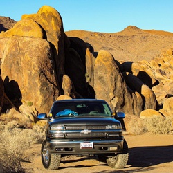
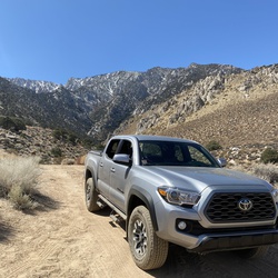
    This was the first time taking my stock Pro4x off-roading. The trail was designated as “more” difficult. It is tight in some points and you will get some scratches. Truck made it through with no issues. Would do it again.
    ★ ★ ★

    user_profile
    JazzyWetsuit7587 3 years, 11 months ago
    Reyes Peak
    The views are stunning! As we gain altitude, a blanket of clouds was seen from many of the hike points. Isolated trail, hardly any wildflowers, lots of mosquitos, shady with some fully exposed to the sun areas. Bring lots of water and bug repellent.
    ★ ★ ★ ★ ★

    user_profile
    QuietSage6188 3 years, 11 months ago
    Sespe Creek Trail - Bear Creek
    Very exposed trail. Bring more water than you think you need. BEAUTIFUL. And I can’t wait to come back when the water is a little higher for swimming.
    ★ ★ ★ ★ ★

    user_profile
    gwoottonla 3 years, 11 months ago
    Haddock Camp via Gene Marshall Piedra Blanca National Recreation Trail
    This hike takes you through some fairly remote terrain and I didn’t see anyone for my hike. The section between Twin Forks and Haddock is especially beautiful. I encountered a rattlesnake on Piedra Blanca and spotted two bears about a 1/4 mile from camp so bring a Ursack for food protection. Heads up, the trail is faint in some places. Water wasn’t flowing but pooled in areas to easily filter.
    ★ ★ ★ ★

    user_profile
    Michael Tagg 4 years ago
    Pinos, Sawmill and Grouse Peaks (5/15/22, 10:51:54AM)
    Great hike, beautiful area with great views and almost no snow. Only drawback was that the peaks did not have much prominence but overall a must do for locals in the 805.
    ★ ★ ★ ★

    user_profile
    CalmFlask4800 4 years ago
    Jeep Miller Trail to Gorman
    Amazing trouble but definitely not for beginners intermediate to advanced need apply only
    ★ ★ ★ ★ ★

    user_profile
    SolidWood1875 4 years, 3 months ago
    Track (2/12/22, 7:18:25AM)
    We hiked in to Vincente Flat approx 5.4 miles from Kirk Creek trail head. Set up camp and continued 7 miles up to cone peak. There is a section of the trail up the creek from camp which is washed out, we followed Cairns and our app and picked up the trail about 1miles after leaving camp. The creek is last place to fill up water. From there its approx 1.7 Miles of switchbacks to a fire road, 2 Miles on the fire road and then 2.3 on a single track up to the summit.
    ★ ★ ★ ★ ★

    user_profile
    Mike Thomas 4 years, 4 months ago
    Track (1/16/22, 7:31:30AM)
    Hiked Sisar to white Ledge a few times but always in the dry time. Today, went to Nordhoff Rd. Made it a 7 mile one way. Lots of color and water made it for a great experience.
    ★ ★ ★ ★ ★

    user_profile
    bearbear 4 years, 7 months ago
    Agua Blanca Trail
    Report coming soon...
    ★ ★ ★ ★ ★

    user_profile
    LastVista4930 4 years, 8 months ago
    6+ mi, training: iPhone died
    Good hike on paved roads: forest closed because of fire danger
    ★ ★ ★

    user_profile
    LastVista4930 4 years, 8 months ago
    Morning wake up, Pine Mountain Club
    Wake up, adjusting to altitude before heading into Sierra. Pine Mountain Club is surrounded by Los Padres National Forest, sadly closed because of fires and fire danger. 8000+ ridges close when conditions permit.
    ★ ★ ★

    user_profile
    LightDusk7605 4 years, 11 months ago
    Adobe trail
    Adobe trail is located off Hwy 166, in Santa Barbara / San Luis Obispo County. This hike is most enjoyable if started early in the morning before the heat of the day. This part of the Los Padres Nat Forest would be considered coastal mountainous high desert with chaparral & scattered oaks. 6 mile out & back hike. Part the hike skirts a creek but is mostly dry year round.
    ★ ★ ★ ★

    user_profile
    hikingfeet 5 years ago
    Track (5/30/21, 8:00:12AM)
    Go early. Steep up. Steep down. Worth the effort.
    ★ ★ ★ ★

    user_profile
    CoolSwamp8734 5 years ago
    Cone Peak via Stone Ridge Trail
    Awesome!
    ★ ★ ★ ★ ★

    user_profile
    DaringIsland5447 5 years ago
    Track (5/15/21, 4:07:50PM)
    First time hiking Pine Ridge trail . Brutal climb from the start. All spots were taken at Barlow and Sykes on Saturday . Everyone cleared out on Sunday . Enjoyed the River and hot springs all to my self.
    ★ ★ ★ ★ ★

    user_profile
    NPkGOVm 5 years ago
    Track (4/27/21, 12:19:14PM)
    This hike 0.5 mile hike to the waterfall is beautiful!
    ★ ★ ★ ★ ★

    user_profile
    Mark Pestrella 5 years, 2 months ago
    Piedra Blanca Camp to Piedra Blanca Trailhead
    Nice place when the weather is right and the water is high. Tough when the temp is over 75.
    ★ ★ ★ ★

    user_profile
    HighTri6853 5 years, 2 months ago
    Willet Hot Spring via Sespe River Trail
    Comfortable weather for this exposed hike 3/24-25. Still a well-travelled path; we pitched camp at a site a little too close to the trail to avoid the noise of late comers and goers to the spring. A few nice campsite options along the way. If the water is high enough in hotter weather seems worth camping along Sespe creek just for swimming holes.
    ★ ★ ★

    user_profile
    PaleWatch9887 5 years, 2 months ago
    Cielo Vista
    This short out-and-back hike was a really nice surprise. The short hike was well worth the views of the California Coast at the end. We really enjoyed a lot of different plants, many in bloom; on the way up and back. I would definitely recommend this hike. There was even a little picnic bench at the end so you could have lunch and enjoy the view. The trail itself was well maintained and easy to follow. We parked in a nice dirt parking spot on the opposite side of the road.
    ★ ★ ★

    user_profile
    egran71 5 years, 3 months ago
    Track (2/27/21, 3:59:27PM)
    Apparently this camp site is closed bc of artillery rounds were found. Probably never to be open for a very very long time 😢
    ★

    user_profile
    SantaCruzFDmedic 5 years, 3 months ago
    Santa Lucia Memorial Park Campground via Indians Road
    BEWARE! The ticks out here are horrible. if you plan on going please please wear long, light colored pants and tick check often. My son was bitten here last year and contracted lymes disease. Thankfully I kept the infected tick and we caught it early but it is still nothing to risk.
    ★

    user_profile
    SlyGoggles1119 5 years, 4 months ago
    2021/1/10 Live Oak short stroll
    Jamie on Mosca Patfish on Tobe Bunnie on Gretzky Shayna on Winston
    ★ ★ ★ ★

    user_profile
    GrandBinos6118 5 years, 5 months ago
    Track (12/20/20, 10:14:04AM)
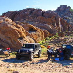
    This was a great ride with a little bit of everything from easy to moderate difficulty. $5 to enter the area was worth the work they have done to the area ( bathrooms, camp area, signage etc etc ). Can be busy but the amount of space made it seem remote. Remember to stay to your side on the corners and watch for criss traffic and you’ll be fine.
    ★ ★ ★ ★

    user_profile
    FastBinos4400 5 years, 6 months ago
    Track (11/26/20, 1:01:59PM)
    Nice hike with my kids (4 and 7) and our dog. The trail is well seen and is in good shape with just a few areas of erosion. Thank you to our under resourced wilderness professionals for keeping our lands accessible.
    ★ ★ ★ ★ ★

    user_profile
    LongTempest9510 5 years, 6 months ago
    Howard creek hike
    Great moderate hike poison oak on north facing slopes
    ★ ★ ★ ★

    user_profile
    OldCliff1744 5 years, 7 months ago
    Mount Pinos
    Easy hike for newbies, well maintained trail.
    ★ ★ ★ ★ ★

    user_profile
    ArchRaceBib6150 5 years, 7 months ago
    Ragged Point forest road to Bald Top
    Good work out with great views!!
    ★ ★ ★ ★ ★

    user_profile
    DryGrove8604 5 years, 8 months ago
    Willet Hot Spring via Sespe River Trail
    Took this only as far as Willet Hot Spring. Difficult in the heat, lots of sand to hike through on the trail, best bet is to hike out in the morning hours and jump in the creek in various spots along the way at the day progresses. Beautiful area, Willet was clean and incredible.
    ★ ★ ★ ★

    user_profile
    w98H6qKp 5 years, 9 months ago
    Ranger Point
    It was hot and lots of bugs. Probably wrong time of the year for this area. Also, the views were hampered by the smoke from fires.
    ★ ★ ★

    user_profile
    SilentCompass4157 5 years, 9 months ago
    Cruickshank Campground via Cruickshank Trail
    Took this trail on the hottest weekend of the year thus far. The first mile or so up the switchbacks was brutal in the still heat, but manageable if you go at your own pace. After that the trail mellows out significantly and cools down with the shade cover. A little overgrown in parts, I recommend wearing pants. Villa Creek camp has plenty of flowing water and some really beautiful swimming spots. Great place to hangout and cool off after the hike in. Overall, given the busyness of Big Sur during Covid, we ran into 5 or 6 other groups of backpackers, but we fortunately got in early enough to get a secluded spot. Remember to always pack in and pack out! And print out your fire permit before you go if you plan on using a stove!
    ★ ★ ★ ★

    user_profile
    CFarms Springville, CA 5 years, 9 months ago
    Willet Hot Spring via Sespe River Trail
    Hiking this weekend.
    ★ ★ ★

    user_profile
    ArtsyHolly9057 5 years, 10 months ago
    Old TV Tower Road
    Beautiful views, great for picnics or an overnight. Can be done in a car, Jeep, hike or bike.
    ★ ★ ★ ★ ★

    user_profile
    MistyHeather1833 5 years, 11 months ago
    Timber Top
    About 3 miles to the top. Almost up the entire time. Great views. Well marked trail has some over growth from the time off, but the trail can still easily be followed. No water.
    ★ ★ ★ ★

    user_profile
    FizzyIsland5814 5 years, 11 months ago
    Thorn Point - Los Padres
    Great day! Was about 82 at the trailhead. Couldn’t get all the way to the trailhead campground. The road ends at the corral. Saw a fox snag a quail and run off it with. Was pretty wild.
    ★ ★ ★ ★

    user_profile
    FizzyIsland5814 6 years ago
    Alamo Mt
    Gorgeous on top of this ridge. Would nice to camp up there! Waypoint for register
    ★ ★ ★ ★

    user_profile
    FizzyIsland5814 6 years ago
    McDonald Peak
    McDonald is a nice view down into the condor wilderness and some gorgeous terrain! Also I forgot to finish my track sorry about that >.< Waypoint for register. Which was eaten up by mice so isn’t really intact
    ★ ★ ★ ★

    user_profile
    FizzyIsland5814 6 years ago
    Beartrap Bluff
    Great hike and awesome camp grounds for thru hikers. The scramble description from hps doesn’t explain well enough how steel and difficult that is
    ★ ★ ★ ★

    user_profile
    DarkTri7694 6 years, 1 month ago
    Freeman water tower to Bernini trail head
    Nice little hike up to the snow line and back.
    ★ ★ ★ ★ ★

    user_profile
    kevinzhang1007 6 years, 1 month ago
    Trail Spring Camp Loop via Vincente Flat Trail
    Awesome views from cone peak. We did the loop counter clockwise from Vicente flats. The backside from Trail Springs to Vicente flats is very overgrown. There are tunnels of poison oak. Expect to bushwhacked with your rain jacket and rain pants.
    ★ ★ ★ ★

    user_profile
    lukeclementphoto 6 years, 3 months ago
    Cerro Alto Campground to Bridge Trail, San Luis Obispo County, CA, USA
    One of my favorite local hikes for sure. 360 degree view. You can see from Pismo to ragged point, and on clear days all the way to the sierras.
    ★ ★ ★ ★

    user_profile
    Brennan Nerhus 6 years, 5 months ago
    Track (10/20/19, 11:08:15AM)
    Easy hike to get above it all
    ★ ★ ★ ★ ★

    user_profile
    Jim S Kenney 6 years, 5 months ago
    San Cayetano
    Amazing
    ★ ★ ★ ★ ★

    user_profile
    HugeZipline1949 6 years, 6 months ago
    Refugio Road to West Camino Cielo to CA154 (10/27/19, 4:04:34PM)
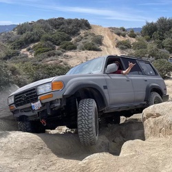
    This road is paved half of the way, almost to Broadcast Peak. Then it turns into a fun rocky and dirt road. I’m a novice wheeler in a stock JKU and had no problems. Took a little longer than I expected.
    ★ ★ ★ ★ ★

    user_profile
    Jim S Kenney 6 years, 7 months ago
    Frazier Mountain
    Started at 8 in the parking lot. This is a steady uphill grind for 7 miles. The views on top was very nice.
    ★ ★ ★ ★

    user_profile
    LastVista4930 6 years, 9 months ago
    Mt pinos
    Drove in to campground, sauntered over, achieved the peak! Then moved car to Chumash Wilderness and Grouse Mountain followed by Sawmill: no strolling involved on that part.
    ★ ★ ★ ★ ★

    user_profile
    LastVista4930 6 years, 9 months ago
    Cerro Noroeste, Grouse Mountain, Sawmill Peak
    Steep grades, good trails, beautiful views with alpine flowers and lots of shade. Only one rattlesnake.
    ★ ★ ★ ★ ★

    user_profile
    LastVista4930 6 years, 9 months ago
    Potrero Seco, Pine Mt Camp & Beyond
    Lots of thistle on nice, flat part of trail near the campground. Beautiful views, old road.
    ★ ★ ★ ★ ★

    user_profile
    LushPine7341 6 years, 9 months ago
    Hike out to Villa Camp
    Short portion after climb out from RT1 overgrown but passable. Buggy during day but not the worst; staying at Villa Camp. Plenty of running water in stream.
    ★ ★ ★ ★

    user_profile
    DryGaiters8230 6 years, 11 months ago
    Cuyama River to Cable Corral Road
    Pretty sweet off road trail. Took my 97 4Runner on it stock, except 31” all terrains. Clearance was good except for the trailer hitch. I probably hit that every other bump lol. Good views and trail kept well
    ★ ★ ★ ★ ★

    user_profile
    Jaime Navarro 7 years ago
    Matilija Trailhead to Matilija Creek
    Great trail, will get feet wet crossing over the creek on several crossings.
    ★ ★ ★ ★ ★

    user_profile
    HugeBeach5102 7 years ago
    Tan Bark Trail and Tin House Fire Road Loop
    This was hard at times but so worth it. incredible views. Changing vistas from forest to crest to wildflower scrub. It felt like three hikes in one.
    ★ ★ ★ ★ ★

    user_profile
    Mateo Corsko 7 years ago
    Cone peak/Stone ridge loop
    Started at highway 1, camped at Vicente and made that our base camp. As of 5/14, Vicente had plenty of water and the trail from H1 to camp was littered with wildflowers. Goat camp, Espinosa and Trail Spring all had water nearby or through camp. The Stone Ridge Loop counter-clockwise from Vicente was amazing. Covered so many different types of terrain ad ecosystems. One of the most diverse I've ever done. It started to get pretty overgrown after we got past Goat Camp, but it was far from un-manageable; a lot of poison oak, so be wary. For us, the overgrown trail made it more fun and unique and interesting but it also slowed down our pace quite a bit. Add at least an hour, more likely two to your normal pace to account for overgrown trail, epic views, and caution for poison oak. Highly suggest doing the trail the same direction we did...I can't imagine going up that section near Goat. BRING BUG SPRAY.
    ★ ★ ★ ★ ★

    user_profile
    FreeZipline8862 7 years, 2 months ago
    Add 2.5 miles or so to the hike because the access road may be closed getting to the trailhead. This hike is very difficult. I had to turn back about 6 miles in, as there was a very long narrow ledge with a steep drop I didn’t think my pup and I would be able to make. Just wasn’t worth the risk to me. It rained often and was chilly in March when I went through in the upper 40’s 😭. I’ll be back and will take the other trail in instead.
    ★ ★ ★ ★ ★

    user_profile
    Michael Mueller 4 days, 22 hours ago
    Barlow Flat Camp via Pine Ridge Trail
    ★ ★

    user_profile
    sustainablesur 6 days, 3 hours ago
    Trail and Santa Lucia Trail
    ★ ★ ★ ★

    user_profile
    SharpRaceBib4076 1 week ago
    Saturday Morning Hiking
    ★

    user_profile
    mack noren 1 week, 3 days ago
    aidan and i versus 1 million bugs
    ★ ★ ★ ★

    user_profile
    Ezgi 2 weeks, 1 day ago
    Sespe Hot Springs via Jonhston Ridge Trail
    ★ ★ ★

    user_profile
    DawnHarness8195 2 weeks, 6 days ago
    Frazier Park (James & Pickles)
    ★ ★ ★ ★ ★

    user_profile
    jmt5220 1 month, 1 week ago
    Horse pack M schoolhouse 2026
    ★ ★ ★ ★ ★

    user_profile
    DarkLake3103 1 month, 2 weeks ago
    Ewoldsen Trail to Bench and Tin House
    ★ ★ ★ ★ ★

    user_profile
    emed2019 1 month, 2 weeks ago
    Monday Morning Activity
    ★ ★

    user_profile
    garrettbush 1 month, 2 weeks ago
    B camper white ledge
    ★ ★ ★ ★ ★

    user_profile
    YoungDawn8427 1 month, 3 weeks ago
    Saturday Afternoon Activity
    ★ ★ ★ ★ ★

    user_profile
    Abdon Mai 1 month, 4 weeks ago
    Tanbark Trail
    ★ ★ ★ ★ ★

    user_profile
    bwhaggie 3 months, 2 weeks ago
    Saturday Morning Activity
    ★ ★ ★ ★

    user_profile
    MistyLamp3949 3 months, 2 weeks ago
    Saturday hike out Vincente
    ★ ★ ★ ★ ★

    user_profile
    Gabriel 4 months, 3 weeks ago
    Tassajera Peak via Tv Tower Road
    ★ ★

    user_profile
    EarlyTree3029 5 months ago
    Saturday Morning Activity
    ★ ★

    user_profile
    Joseph 5 months, 1 week ago
    Sykes Hot Spring via Pine Ridge Trail
    ★

    user_profile
    Anthony 5 months, 4 weeks ago
    Sunday Morning Activity
    ★ ★ ★ ★ ★

    user_profile
    Alex Hsu 6 months, 2 weeks ago
    Big Sur Adv Route #2
    ★

    user_profile
    John Stonecipher 6 months, 3 weeks ago
    Cruickshank Trail Big Sur
    ★ ★ ★ ★

    user_profile
    Sean Walsh 7 months, 2 weeks ago
    Espinosa Camp via Vincente Flat Trail
    ★

    user_profile
    SlowTri1919 7 months, 2 weeks ago
    Bench Loop via Ewoldsen trail
    ★ ★ ★ ★

    user_profile
    BoyLondon 7 months, 2 weeks ago
    19 Oaks (Pre-Rain) 10-13-25
    ★

    user_profile
    Timothy Williams 7 months, 2 weeks ago
    Mt. Old Man and Mt. Arido
    ★ ★ ★ ★ ★

    user_profile
    Lesley 8 months ago
    Sespe Hot Springs PR
    ★ ★ ★ ★

    user_profile
    Gabriel 8 months ago
    Sunday Night Activity
    ★ ★ ★ ★ ★

    user_profile
    Joseph 8 months, 3 weeks ago
    Thursday Morning Activity
    ★ ★ ★ ★ ★

    user_profile
    SnowyOlive1751 8 months, 4 weeks ago
    Black Diamond Finger
    ★ ★ ★ ★ ★

    user_profile
    SharpRaceBib8731 9 months, 3 weeks ago
    Frazier Park
    ★ ★ ★ ★

    user_profile
    Sam Ali 9 months, 4 weeks ago
    Mount Pinos Road
    ★ ★

    user_profile
    Nastasha White 10 months ago
    Hi Mountain
    ★

    user_profile
    Dillon 10 months ago
    Rays Camp via Manzana Trail
    ★ ★ ★ ★ ★

    user_profile
    dlinstrom 10 months, 3 weeks ago
    Sunday Morning Hiking
    ★ ★ ★ ★ ★

    user_profile
    SweetCanoe6794 11 months, 2 weeks ago
    Saturday Morning Hiking
    ★

    user_profile
    GrandYoga1953 11 months, 3 weeks ago
    Mojavi park
    ★ ★ ★ ★ ★

    user_profile
    Jon Marcus Dorotheo 1 year ago
    Saturday Morning Activity
    ★ ★ ★ ★ ★

    user_profile
    SnowyOlive1751 1 year ago
    The Five Fingers
    ★ ★ ★ ★ ★

    user_profile
    SlowTree7658 1 year, 1 month ago
    Big Sur Station to Barlow Flats
    ★ ★ ★ ★

    user_profile
    Ben Allcott 1 year, 1 month ago
    McKinley Springs
    ★ ★ ★ ★

    user_profile
    SharpGoggles7657 1 year, 1 month ago
    Friday Lunch Overlanding
    ★ ★ ★ ★ ★

    user_profile
    GroovyCaving9461 1 year, 1 month ago
    Manuel Peak
    ★ ★

    user_profile
    snmartinez1 1 year, 2 months ago
    Thursday Lunch Activity
    ★ ★ ★ ★

    user_profile
    Jonathan Skelding 1 year, 2 months ago
    Saturday Morning Activity
    ★ ★ ★ ★ ★

    user_profile
    cammyshields 1 year, 2 months ago
    Espinosa Camp via Vincente Flat Trail
    ★ ★

    user_profile
    Jasmin 1 year, 2 months ago
    10 mile hike with fineeee shyyytt
    ★ ★ ★ ★ ★

    user_profile
    Casey Persson 1 year, 3 months ago
    Day 1 - Piru Parking to Log Cabin
    ★

    user_profile
    Alvin 1 year, 3 months ago
    Nordhoff Peak via Nordhoff Ridge Road and Chief Peak Road
    ★ ★

    user_profile
    DougsRV 1 year, 3 months ago
    Cero Alto Trail Loop
    ★ ★ ★ ★ ★

    user_profile
    AmpleBirch3673 1 year, 4 months ago
    Beartrap Campsite via Gene Marshall Piedra Blanca National Recreation Trail
    ★ ★ ★ ★

    user_profile
    DaringPrairie9674 1 year, 4 months ago
    Trail Spring Camp Loop via Vincente Flat Trail
    ★ ★

    user_profile
    Amalia 1 year, 4 months ago
    Chorro Grande Trail (Los Padres)
    ★ ★ ★ ★ ★

    user_profile
    YoungGrove7293 1 year, 5 months ago
    Mono Campground via Cold Spring Trail
    ★ ★ ★ ★ ★

    user_profile
    HotLeaf3200 1 year, 5 months ago
    Track (6/9/24, 10:18:19AM)
    ★ ★ ★ ★

    user_profile
    LightCanoe9359 1 year, 6 months ago
    Motorcycle with Diego and Jason
    ★ ★ ★ ★ ★

    user_profile
    sustainablesur 1 year, 6 months ago
    Santa Lucia Trail
    ★ ★ ★ ★

    user_profile
    alan 1 year, 6 months ago
    Arroyo Seco
    ★

    user_profile
    mvaralyay 1 year, 6 months ago
    Track (5/11/22, 10:01:37AM) Lizard Head (& Cuyama Peak)
    ★ ★

    user_profile
    Sean 1 year, 6 months ago
    Los Padres National Forest Hike
    ★ ★ ★ ★ ★

    user_profile
    Joe 1 year, 7 months ago
    Saturday Morning Activity
    ★ ★ ★ ★ ★

    user_profile
    CoolYoga9526 1 year, 7 months ago
    Eagles Rest Peak (Adam)
    ★ ★ ★ ★ ★

    user_profile
    phongxnguyen2002 1 year, 7 months ago
    Sunday Morning Activity
    ★ ★ ★ ★ ★

    user_profile
    WarmMtBoots5978 1 year, 7 months ago
    McPhearson Peak and Peak Mountain Trail
    ★ ★ ★ ★ ★

    user_profile
    Jeffrey Swain 1 year, 7 months ago
    Burro Benchmark
    ★ ★ ★

    user_profile
    Kim 1 year, 8 months ago
    Mount Pinos Trail
    ★ ★ ★ ★ ★

    user_profile
    TallHeather5814 1 year, 8 months ago
    Mount Pinos via McGill Trail
    ★

    user_profile
    sustainablesur 1 year, 8 months ago
    Camp Cawatre Firebreak
    ★ ★ ★ ★

    user_profile
    sustainablesur 1 year, 8 months ago
    Camp Cawatre Firebreak
    ★ ★ ★ ★

    user_profile
    sustainablesur 1 year, 8 months ago
    Camp Cawatre Firebreak
    ★ ★ ★ ★

    user_profile
    sustainablesur 1 year, 8 months ago
    Camp Cawatre Firebreak
    ★ ★ ★ ★

    user_profile
    sustainablesur 1 year, 8 months ago
    Camp Cawatre Firebreak
    ★ ★ ★ ★

    user_profile
    sustainablesur 1 year, 8 months ago
    Camp Cawatre Firebreak
    ★ ★ ★ ★

    user_profile
    sustainablesur 1 year, 8 months ago
    Arroyo Seco Ridge Usetrail
    ★ ★ ★ ★

    user_profile
    sustainablesur 1 year, 8 months ago
    Arroyo Seco Ridge Usetrail
    ★ ★ ★ ★

    user_profile
    sustainablesur 1 year, 8 months ago
    Arroyo Seco Ridge Usetrail
    ★ ★ ★ ★

    user_profile
    sustainablesur 1 year, 8 months ago
    Arroyo Seco Ridge Usetrail
    ★ ★ ★ ★

    user_profile
    sustainablesur 1 year, 8 months ago
    Arroyo Seco Ridge Usetrail
    ★ ★ ★ ★

    user_profile
    sustainablesur 1 year, 8 months ago
    Arroyo Seco Ridge Usetrail
    ★ ★ ★ ★

    user_profile
    emed2019 1 year, 8 months ago
    Monday Morning Activity
    ★ ★ ★ ★ ★

    user_profile
    SanchezDirty 1 year, 9 months ago
    Silver Camp Loop via Salmon Creek Trail and Cruickshank Trail
    ★ ★ ★ ★ ★

    user_profile
    CrispField9646 1 year, 9 months ago
    Track (8/17/24, 3:44:36PM)
    ★

    user_profile
    YoungPond1708 1 year, 10 months ago
    Up santa lucia peak
    ★ ★ ★ ★ ★

    user_profile
    Steven Hoeschele 1 year, 10 months ago
    Dry Canyon Road
    ★

    user_profile
    GrandSwamp6569 1 year, 10 months ago
    Sespe River Trail
    ★ ★ ★ ★ ★

    user_profile
    SharpGrove2375 1 year, 11 months ago
    Estrella Camp via Salmon Creek Trail
    ★

    user_profile
    BusyHazel1552 1 year, 11 months ago
    Plaskett Creek Campground via Cabrillo Highway
    ★ ★ ★ ★ ★

    user_profile
    JovialSwimCap3093 1 year, 11 months ago
    Rainbow Camp
    ★ ★ ★

    user_profile
    jmt5220 1 year, 11 months ago
    Pendola drive and hike
    ★ ★ ★ ★

    user_profile
    WarmPine2146 2 years ago
    Haddock Camp via Reyes Peak Trail 23W04
    ★ ★ ★ ★ ★

    user_profile
    Beck Kiely 2 years ago
    Manzana Narrows Camp via Manzana Trail
    ★ ★ ★ ★ ★

    user_profile
    smikeys 2 years ago
    Track (5/1/24, 4:08:59PM)
    ★ ★ ★ ★ ★

    user_profile
    joseph nielsen 2 years, 1 month ago
    Pine Valley via Pine Ridge Trail and Church Creek Trail
    ★ ★ ★

    user_profile
    StrongCaving3493 2 years, 2 months ago
    Piru Ohv
    ★ ★ ★ ★ ★

    user_profile
    4Nacho 2 years, 2 months ago
    Track (3/17/24, 10:50:39AM)
    ★ ★ ★ ★ ★

    user_profile
    NobleAlder8644 2 years, 2 months ago
    Manzana Trail to Schoolhouse
    ★ ★ ★ ★ ★

    user_profile
    DizzyCompass8046 2 years, 2 months ago
    Barlow Flat Camp via Pine Ridge Trail
    ★ ★

    user_profile
    AmplePeak4434 2 years, 2 months ago
    Willet Hot Spring via Sespe River Trail
    ★ ★ ★ ★

    user_profile
    ToughSurf7029 2 years, 2 months ago
    Matilija Trailhead via Matilija Canyon Road North
    ★

    user_profile
    Clwhipple 2 years, 3 months ago
    Nordhoff Peak via Nordhoff Ridge Road and Chief Peak Road
    ★ ★

    user_profile
    Harrison Bray 2 years, 3 months ago
    Sespe River Trail
    ★ ★

    user_profile
    SnowyRunBelt9309 2 years, 3 months ago
    Track (1/19/24, 8:48:30AM)
    ★ ★ ★ ★ ★

    user_profile
    ChillyWatch4654 2 years, 4 months ago
    Big Sur - January 2024
    ★ ★ ★ ★ ★

    user_profile
    Robert Sky 2 years, 4 months ago
    Espinosa Camp via Vincente Flat Trail
    ★

    user_profile
    GrandSwamp3437 2 years, 4 months ago
    Track (1/13/24, 8:44:29AM)
    ★ ★ ★

    user_profile
    FreshBike3894 2 years, 4 months ago
    Sespe Hot Springs via Sespe River Trail
    ★ ★ ★ ★ ★

    user_profile
    AlertLily4093 2 years, 4 months ago
    Willet Hot Spring via Sespe River Trail
    ★ ★ ★ ★ ★

    user_profile
    Don Montilla 2 years, 4 months ago
    Sykes Hot Spring via Pine Ridge Trail
    ★ ★

    user_profile
    ArtsyEGels4060 2 years, 4 months ago
    Kirk Creek Campground via Nacimiento-Fergusson Road and Plasket Ridge Road
    ★ ★

    user_profile
    Nathan76I8aR 2 years, 4 months ago
    Pozo Summit via Pine Mountain Road
    ★

    user_profile
    HardHarbor2409 2 years, 4 months ago
    Plaskett Creek Group Campground via Plaskett Ridge Road
    ★ ★

    user_profile
    RichFern8335 2 years, 5 months ago
    Track (12/24/23, 11:20:31AM)
    ★ ★ ★ ★ ★

    user_profile
    Christopher Botti 2 years, 5 months ago
    Miller
    ★ ★ ★ ★ ★

    user_profile
    DustyGrove6555 2 years, 6 months ago
    Sykes Hot Springs to my Tent
    ★ ★ ★ ★ ★

    user_profile
    FreeBay8259 2 years, 6 months ago
    Sykes Camp via Pine Ridge Trail
    ★ ★ ★ ★ ★

    user_profile
    RichUpland3685 2 years, 6 months ago
    Chester Spring via Pine Mountain Road and Pine Mountain
    ★

    user_profile
    DirectMoss7674 2 years, 6 months ago
    Track (11/6/23, 9:17:58AM)
    ★ ★ ★ ★ ★

    user_profile
    SlimCamp3470 2 years, 6 months ago
    Sykes Hot Springs
    ★ ★ ★ ★

    user_profile
    FlyEaglesFly 2 years, 7 months ago
    Beartrap Campsite via Gene Marshall Piedra Blanca National Recreation Trail
    ★ ★ ★ ★ ★

    user_profile
    AiryCanoe5602 2 years, 7 months ago
    Haddock Camp via Gene Marshall Piedra Blanca National Recreation Trail
    ★

    user_profile
    batoul.banihashemi 2 years, 8 months ago
    Kirk creek to Cone peak
    ★ ★ ★ ★ ★

    user_profile
    MildLake9421 2 years, 8 months ago
    Prewitt Ridge Trail
    ★ ★

    user_profile
    SnugRavine9143 2 years, 9 months ago
    Track (8/5/23, 6:45:31AM)
    ★ ★ ★ ★ ★

    user_profile
    Rafael Schmitt 2 years, 10 months ago
    Hotspring trail
    ★

    user_profile
    Rafael Schmitt 2 years, 10 months ago
    Hotspring trail
    ★

    user_profile
    HotMist9405 2 years, 10 months ago
    Sykes Hot Spring via Pine Ridge Trail
    ★ ★ ★ ★ ★

    user_profile
    PeachyOasis7388 2 years, 11 months ago
    Track (6/23/23, 7:08:20AM)
    ★ ★ ★ ★ ★

    user_profile
    Jeremy Shirley 2 years, 11 months ago
    Saturday Forest exposure
    ★ ★ ★

    user_profile
    tcallahan 2 years, 11 months ago
    SRW day 1
    ★ ★ ★ ★ ★

    user_profile
    OldGlade1894 2 years, 11 months ago
    Track (6/12/23, 1:35:57PM)
    ★ ★ ★ ★ ★

    user_profile
    ChillyWatch4654 2 years, 11 months ago
    Ventana - June 2023
    ★ ★ ★ ★ ★

    user_profile
    Kate C 2 years, 11 months ago
    Carrizo Springs Rustic Campsite via Carrizo Creek Trail
    ★

    user_profile
    SweetGoggles4846 3 years ago
    Barlow flat campground:Los padres national park
    ★ ★ ★ ★

    user_profile
    GaleXC-Ski1901 3 years ago
    San Emigdio Mountain via Forest Route 9N34
    ★ ★

    user_profile
    davidkatzcreative 3 years ago
    Timber top, 11/5/22 (vic t, jimbo, Brit Ryan, mal dog, sincity)
    ★ ★ ★ ★ ★

    user_profile
    ClearMtBoots3038 3 years ago
    Gene Marshall Piedra Blanca Trailhead Parking, Ventura County to Ventura County, CA, USA
    ★ ★ ★

    user_profile
    DryHelmet2612 3 years, 1 month ago
    Fig mountain willow springs loop wildflowers
    ★ ★ ★ ★ ★

    user_profile
    Margaritox 3 years, 1 month ago
    Frazier mines
    ★

    user_profile
    Rocque 3 years, 1 month ago
    McKinley Springs Camp via Forest Service Route 8N08
    ★ ★ ★ ★ ★

    user_profile
    GentleAurora6919 3 years, 2 months ago
    46.0 via Pine Ridge Trail
    ★ ★

    user_profile
    Dylan Rief 3 years, 2 months ago
    Bike to Nira
    ★ ★ ★

    user_profile
    fdevans 3 years, 3 months ago
    Ballinger Canyon 24-31-40
    ★ ★ ★ ★ ★

    user_profile
    jmt5220 3 years, 3 months ago
    NIRA Manzana so 2/3/23
    ★ ★ ★ ★ ★

    user_profile
    SnowyCanteen1147 3 years, 4 months ago
    Franklin Trail
    ★ ★ ★ ★ ★

    user_profile
    reneirenem 3 years, 4 months ago
    Timber top
    ★

    user_profile
    ClearWBottle9074 3 years, 5 months ago
    Figueroa Lookout
    ★ ★ ★ ★ ★

    user_profile
    SoundGaiters8415 3 years, 5 months ago
    Yoshie Trip
    ★ ★ ★ ★ ★

    user_profile
    FairBreeze7576 3 years, 6 months ago
    Buzzard’s Roost
    ★ ★ ★ ★

    user_profile
    FunnyCanoe4191 3 years, 6 months ago
    Big Sur Station to Terrace Creek Campsite
    ★ ★ ★ ★

    user_profile
    Warrenize 3 years, 7 months ago
    Lockwood Route 100
    ★ ★ ★ ★

    user_profile
    QuickOlive9492 3 years, 7 months ago
    Nacimiento Campground via Nacimiento-Fergusson Road
    ★ ★ ★

    user_profile
    FreeMaple2197 3 years, 7 months ago
    Sykes Hot Spring via Pine Ridge Trail
    ★ ★ ★ ★

    user_profile
    DustyLowland3035 3 years, 7 months ago
    Track (10/8/22, 6:13:18AM)
    ★ ★ ★ ★ ★

    user_profile
    ClearTundra1687 3 years, 7 months ago
    Manzana Narrows Camp via Manzana Trail
    ★ ★ ★ ★ ★

    user_profile
    DustyGulch8300 3 years, 7 months ago
    San Martin Top to Prewitt Ridge Campground
    ★ ★ ★ ★ ★

    user_profile
    BoldBluff1739 3 years, 8 months ago
    Ventana Double Cone via Ventana Trail
    ★

    user_profile
    Chris Sorenson 3 years, 8 months ago
    Willet Hot Spring via Sespe River Trail
    ★

    user_profile
    QuickSpring9515 3 years, 8 months ago
    Mount Pinos via Condor Summit
    ★ ★

    user_profile
    QuietBinos8846 3 years, 8 months ago
    My. Pinos to alt. CG Camp
    ★ ★ ★ ★ ★

    user_profile
    CrispBamboo3359 3 years, 8 months ago
    Santa Ynez Peak via West Camino Cielo
    ★ ★ ★ ★ ★

    user_profile
    HeroicBluff5119 3 years, 8 months ago
    Track (8/6/22, 4:48:41AM)
    ★ ★ ★

    user_profile
    ianmacd12 3 years, 9 months ago
    Plaskett fire road
    ★ ★ ★ ★ ★

    user_profile
    SlowMaple3348 3 years, 9 months ago
    Mount Pinos via McGill Trail
    ★ ★

    user_profile
    NobleAurora3000 3 years, 10 months ago
    Manuel Peak
    ★

    user_profile
    piambro 3 years, 10 months ago
    2022-07-03 Hard Ride Northwest Gorman
    ★ ★ ★ ★ ★

    user_profile
    yankeec77 3 years, 10 months ago
    Prewitt Ridge Trail
    ★ ★ ★ ★ ★

    user_profile
    EasyFish4859 3 years, 11 months ago
    Hathaway Ridge
    ★ ★ ★ ★ ★

    user_profile
    slapshotdave72 3 years, 11 months ago
    Misfits Hungry Valley
    ★ ★ ★ ★

    user_profile
    remfsy 3 years, 11 months ago
    Track (1/6/21, 8:06:18AM)
    ★ ★ ★ ★ ★

    user_profile
    WittyGale5815 3 years, 11 months ago
    Manzana Narrows Camp via Manzana Trail
    ★ ★ ★ ★

    user_profile
    WarmSurf9131 4 years ago
    Track (5/7/22, 10:41:31AM)
    ★ ★ ★ ★

    user_profile
    FrostyFlask3189 4 years ago
    *D_Lockwood_Miller_Jeep_Trail
    ★ ★ ★ ★ ★

    user_profile
    CuteGoggles4227 4 years ago
    OJMiddleSespeT220511
    ★ ★ ★ ★

    user_profile
    CuteGoggles4227 4 years ago
    OJPiedraBlancaFormationsT220511
    ★ ★ ★ ★

    user_profile stars
    Gordon Alexander 4 years ago
    Fishbowls on Cedar Creek
    ★ ★ ★ ★

    user_profile
    LastYoga9566 4 years ago
    Espinosa Camp via Vincente Flat Trail
    ★

    user_profile
    DurableCave6099 4 years ago
    Matilija Trailhead to North Fork Matilija Trail
    ★ ★ ★ ★ ★

    user_profile
    SlowTree9600 4 years, 1 month ago
    Sawmill Mt
    ★ ★ ★ ★ ★

    user_profile
    jimjim6969 4 years, 1 month ago
    Mt Manny thru hike
    ★ ★ ★ ★ ★

    user_profile
    LongQuarry6136 4 years, 1 month ago
    Mt. Pinos (4/8/22, 10:32:0)
    ★ ★ ★ ★ ★

    user_profile
    EasyCedar3471 4 years, 1 month ago
    Plaskett Ridge Road
    ★

    user_profile
    Micki Honkanen 4 years, 1 month ago
    Cone Peak Loop
    ★ ★

    user_profile
    DawnDawn8362 4 years, 2 months ago
    Track (3/6/22, 09:13:58)
    ★ ★ ★ ★ ★

    user_profile
    Justin Nolan 4 years, 2 months ago
    Track (10/26/21, 8:10:56AM)
    ★ ★ ★ ★ ★

    user_profile
    jmt5220 4 years, 2 months ago
    Track Indian creek March 2022
    ★ ★ ★ ★ ★

    user_profile
    Scott Wolfe 4 years, 2 months ago
    McKinley Mountain
    ★ ★ ★ ★ ★

    user_profile
    HappyYoga1218 4 years, 2 months ago
    Boulder canyon with Kaleb
    ★ ★ ★ ★ ★

    user_profile
    SlyGoggles1119 4 years, 3 months ago
    2022/2/27 cow day at live oak
    ★ ★ ★ ★

    user_profile
    YoungCloud4165 4 years, 3 months ago
    Cerro Alto
    ★ ★

    user_profile
    Colin McDermott 4 years, 3 months ago
    China Camp Campground via Tassajara Road
    ★ ★ ★ ★ ★

    user_profile
    HardGlade4941 4 years, 3 months ago
    Prewitt Ridge Campground Track
    ★ ★ ★ ★ ★

    user_profile
    Cguier 4 years, 3 months ago
    Romero Saddle to Little Caliente via Camuesa Road; Luc and Christian TREK 5
    ★ ★ ★ ★

    user_profile
    Cguier 4 years, 3 months ago
    Gibraltar Connector Trail
    ★ ★ ★ ★ ★

    user_profile
    CalmFish6389 4 years, 3 months ago
    Buckeye Campground via Soda Springs Trail
    ★ ★ ★ ★ ★

    user_profile
    qE0Ogg58 4 years, 3 months ago
    Cone Peak
    ★ ★ ★ ★ ★

    user_profile
    Dahn Han 4 years, 3 months ago
    경로 (2/4/22 오전 6:25:12)
    ★ ★ ★ ★ ★

    user_profile
    SnowyStove3384 4 years, 3 months ago
    White Ledge Campground via Red Reef Trail and Sisar Canyon Road
    ★ ★

    user_profile
    FreeMaple2197 4 years, 3 months ago
    With Kyle
    ★ ★ ★ ★ ★

    user_profile
    SnowyStove3384 4 years, 4 months ago
    Chorro Grande Trail
    ★ ★

    user_profile
    AdmiralSnaxbar 4 years, 4 months ago
    My Pinos Trail
    ★ ★ ★ ★

    user_profile
    DustySequoia3119 4 years, 4 months ago
    Cone Peak via Vincente Flat Trail
    ★ ★

    user_profile
    John Collen 4 years, 4 months ago
    Hi Mountain Campground via Hi Mountain Lookout Road
    ★

    user_profile
    Q1NLYjbL 4 years, 4 months ago
    Track (1/6/22, 9:06:43AM)
    ★ ★ ★ ★ ★

    user_profile
    DapperShore7888 4 years, 4 months ago
    Hi Mountain Campground via Hi Mountain Lookout Road
    ★

    user_profile
    HappyFern6659 4 years, 5 months ago
    Track (12/18/21, 09:36:11)
    ★ ★ ★ ★

    user_profile
    SnowyOlive1751 4 years, 5 months ago
    Alamo Mountain -Dutchman Camp
    ★ ★ ★ ★ ★

    user_profile
    RichCamp4311 4 years, 5 months ago
    Los Burros Road
    ★ ★ ★ ★

    user_profile
    jlsarner 4 years, 6 months ago
    Track (11/24/21, 8:57:15AM)
    ★ ★ ★ ★ ★

    user_profile
    SnowyOlive1751 4 years, 6 months ago
    8N43 Sulphur Springs 23W29
    ★ ★ ★ ★ ★

    user_profile
    SnowyOlive1751 4 years, 6 months ago
    6N03 Potrero Seco (Private)
    ★ ★ ★ ★ ★

    user_profile
    SnowyOlive1751 4 years, 6 months ago
    7N04 Tinta Cyn / Rancho Nuevo CG
    ★ ★ ★ ★ ★

    user_profile
    dlinstrom 4 years, 6 months ago
    Track (11/20/21, 2:54:18PM)
    ★ ★ ★ ★ ★

    user_profile
    GlUA84j0 4 years, 6 months ago
    Timber Top via Coast Ridge Road
    ★

    user_profile
    BarefootBassist 4 years, 6 months ago
    Sawmill Mountain (Mount Pinos, Grouse Mountain)
    ★ ★ ★ ★ ★

    user_profile
    BarefootBassist 4 years, 6 months ago
    Sawmill Mountain (Mount Pinos, Grouse Mountain)
    ★ ★ ★ ★ ★

    user_profile
    mjroth1969 4 years, 7 months ago
    Track (10/28/21, 9:50:38AM)
    ★ ★ ★ ★

    user_profile
    OldDaisy3402 4 years, 7 months ago
    Track (6/12/21, 8:15:32AM)
    ★ ★

    user_profile
    MistyBasin6278 4 years, 8 months ago
    Chester Spring via Pine Mountain Road and Pine Mountain
    ★ ★ ★ ★ ★

    user_profile
    PureAurora2241 4 years, 8 months ago
    Bench Loop via Ewoldsen trail
    ★

    user_profile
    Rainey Hoffman 4 years, 8 months ago
    Santa B hike with O
    ★ ★ ★ ★ ★

    user_profile
    Jon Lieberg 4 years, 9 months ago
    Track (8/29/21, 7:33:40AM)
    ★

    user_profile
    FreeHike4277 4 years, 9 months ago
    Tin House Road trail to Tan Bark trail.
    ★ ★ ★ ★ ★

    user_profile
    EpicRose1684 4 years, 9 months ago
    3 Peaks from Nordic Base
    ★ ★ ★ ★ ★

    user_profile
    TallRainbow1285 4 years, 9 months ago
    Matilija Trailhead to Jamison lake out and back
    ★ ★ ★ ★

    user_profile
    LushBasin6366 4 years, 10 months ago
    Three Peaks Loop via Salmon Creek Trail
    ★ ★ ★

    user_profile
    george110700 4 years, 10 months ago
    Ventana Double Cone via Ventana Trail
    ★ ★ ★ ★ ★

    user_profile
    James Barnett 4 years, 10 months ago
    Sykes Camp via Pine Ridge Trail
    ★

    user_profile
    DarkTree3543 4 years, 10 months ago
    Thorn Meadows via Forest Route 7N03B
    ★ ★ ★ ★ ★

    user_profile
    SafeRaceBib5537 4 years, 11 months ago
    Dry Canyon Road
    ★

    user_profile
    MistyWild8501 4 years, 11 months ago
    ATV Campground via Forest Route 8N01
    ★ ★

    user_profile
    DustyMound6017 4 years, 11 months ago
    Miller Jeep Trail
    ★ ★ ★ ★ ★

    user_profile
    FairHarbor4445 4 years, 11 months ago
    Fishbowls Camp Loop via 21W05
    ★ ★ ★ ★ ★

    user_profile
    TallOasis4507 4 years, 11 months ago
    Frazier lookout
    ★ ★ ★ ★

    user_profile
    TallOasis4507 4 years, 11 months ago
    Frazier lookout
    ★ ★ ★ ★

    user_profile
    GrandBinos6118 4 years, 11 months ago
    Frazier Mtn Ride
    ★ ★ ★ ★ ★

    user_profile
    LightFlurry7661 5 years ago
    Track (5/9/21, 10:34:44AM)
    ★ ★ ★ ★ ★

    user_profile
    four.wheel.travel 5 years ago
    County Line Road
    ★ ★

    user_profile
    davidgordon 5 years ago
    AB Track Edited
    ★ ★ ★ ★ ★

    user_profile
    Katerina 5 years ago
    Track (5/16/21, 13:03:9)
    ★ ★ ★ ★ ★

    user_profile
    LongSkis8767 5 years ago
    Prewitt Ridge Trail
    ★

    user_profile
    CtotheODY 5 years ago
    Pleito Creek
    ★ ★ ★ ★

    user_profile
    RoughWBottle1866 5 years ago
    Tony Trail Primitive Camp via Tony Trail
    ★ ★ ★ ★ ★

    user_profile
    SlyGoggles1119 5 years ago
    2021/5/9 Mothers’ Day MeetUp at 2021/5/9 Mothers’ Day MeetUp Rancho Oso
    ★ ★ ★

    user_profile
    EasyEGels6588 5 years ago
    Cone Peak via Vincente Flat Trail
    ★

    user_profile
    John MacFarlane 5 years, 1 month ago
    Maricopa Highway to Reyes Peak Trail
    ★ ★ ★ ★ ★

    user_profile
    SlimPeak6050 5 years, 1 month ago
    Little Pine Spring Camp to Santa Cruz Guard Station, Santa Barbara County, CA, USA
    ★ ★ ★ ★

    user_profile
    aleksritz 5 years, 1 month ago
    Sespe Hot Springs via Alder Creek Trail
    ★

    user_profile
    Gakki1 5 years, 1 month ago
    Piedra Blanca Trailhead via Rose Valley Road and NFD6N31
    ★ ★ ★ ★

    user_profile
    RedQuarry6756 5 years, 1 month ago
    Buckhorn ridge(4/17/21, 10:35:15AM)
    ★ ★ ★ ★

    user_profile
    DawnTree9038 5 years, 1 month ago
    Track (2/21/21, 09:38:56)
    ★ ★ ★ ★

    user_profile
    Owen Convery 5 years, 1 month ago
    Sespe Hot Springs via Alder Creek Trail
    ★ ★ ★ ★

    user_profile
    MildExplore9230 5 years, 1 month ago
    Lion Den Camp Loop via Salmon Creek Trail
    ★

    user_profile
    BigVine1284 5 years, 1 month ago
    Enchanted Forest, 3/29
    ★ ★ ★ ★ ★

    user_profile
    EasyTrek2707 5 years, 2 months ago
    San Emigdio Mountain via Forest Route 9N34
    ★ ★ ★ ★ ★

    user_profile
    John Stonecipher 5 years, 2 months ago
    Snyder Trail
    ★ ★ ★ ★

    user_profile
    SnowyCycle9591 5 years, 2 months ago
    Nordhoff Peak via Nordhoff Ridge Road and Chief Peak Road
    ★

    user_profile
    WittyGale5815 5 years, 2 months ago
    Hi Mountain
    ★

    user_profile
    HolyBeach1662 5 years, 2 months ago
    Mount Pinos Trail
    ★ ★ ★ ★ ★

    user_profile
    Steven 5 years, 2 months ago
    Track (3/16/21, 11:06:56AM)
    ★ ★ ★ ★ ★

    user_profile
    TheCharlie 5 years, 2 months ago
    Manuel Peak trail
    ★ ★ ★ ★

    user_profile
    TallLedge2417 5 years, 2 months ago
    Nordhoff Tower
    ★ ★ ★

    user_profile
    Pablobmwgs 5 years, 2 months ago
    Track (3/6/21, 8:43:12AM)
    ★

    user_profile
    gabe.mickel 5 years, 2 months ago
    Arroyo Secco 27 Feb 2021
    ★ ★ ★ ★

    user_profile
    egran71 5 years, 2 months ago
    Track (2/28/21, 5:01:36PM)
    ★ ★ ★ ★ ★

    user_profile
    SnugHarness9247 5 years, 3 months ago
    Sepse hot springs
    ★ ★

    user_profile
    TruePalm4583 5 years, 3 months ago
    Mount Pinos via Condor Summit
    ★

    user_profile
    CoolDaisy3360 5 years, 3 months ago
    Track (2/23/21, 08:47:11)
    ★ ★ ★ ★ ★

    user_profile
    ChillyGlen8132 5 years, 3 months ago
    Nature Trail to Snack Bar
    ★ ★ ★ ★

    user_profile
    Brian keefe 5 years, 3 months ago
    Track (2/15/21, 11:45:14)
    ★ ★ ★

    user_profile
    WarmPath2634 5 years, 3 months ago
    Tecuya Mountain Loop via Cold Springs Canyon
    ★

    user_profile
    FairBoots9651 5 years, 3 months ago
    Sawmill Mountain, Los Padres National Forrest, Kern County CA, USA
    ★ ★ ★ ★ ★

    user_profile
    TallLedge2417 5 years, 3 months ago
    First ride at the ranchos
    ★ ★ ★

    user_profile
    LastPeak4949 5 years, 3 months ago
    Middle Santa Ynez Campground via Forest Route 5N33 and Romero Camuesa Road
    ★

    user_profile
    EJ 5 years, 4 months ago
    Track (7/4/20, 9:28:59AM)
    ★

    user_profile
    QuietWillow6551 5 years, 4 months ago
    Track (1/2/21, 10:19:32AM)
    ★ ★ ★ ★ ★

    user_profile
    PeachyFish1409 5 years, 4 months ago
    Piru Canyon Road
    ★ ★ ★ ★

    user_profile
    BreezyMound3135 5 years, 4 months ago
    Manuel Peak
    ★ ★ ★ ★ ★

    user_profile
    Scott Wolfe 5 years, 4 months ago
    Tequepis Trail to Santa Ynez Peak (1/3/21, 7:51:14AM)
    ★ ★ ★ ★ ★

    user_profile
    AcuteSquall8636 5 years, 4 months ago
    Horn Canyon Trail
    ★ ★ ★

    user_profile
    Scott Wolfe 5 years, 5 months ago
    Cachuma Mtn from Cachuma Saddle (12/26/20, 7:58:52AM)
    ★ ★ ★

    user_profile
    Theron Dowell 5 years, 5 months ago
    Frazier park
    ★ ★ ★ ★ ★

    user_profile
    BusyAurora6488 5 years, 5 months ago
    Track (11/25/20, 7:31:39AM)
    ★ ★ ★

    user_profile
    eltonmdoi 5 years, 5 months ago
    Sespe River Trail to Piedra Blanca Creek
    ★ ★ ★ ★ ★

    user_profile
    Scott Wolfe 5 years, 5 months ago
    Manzana/Potrero to Hurricane Deck (12/5/20, 8:13:46AM)
    ★ ★ ★ ★ ★

    user_profile
    John MacFarlane 5 years, 5 months ago
    Franklin (1913 Route)
    ★ ★ ★ ★

    user_profile
    Jim S Kenney 5 years, 5 months ago
    Buck creek, Sewert Peak
    ★ ★ ★ ★ ★

    user_profile
    EasyKayak3266 5 years, 5 months ago
    Ballinger Canyon OHV
    ★ ★ ★ ★ ★

    user_profile
    Leo Alvarez 5 years, 6 months ago
    Fishbowls Springs Trail
    ★ ★ ★ ★

    user_profile
    dlinstrom 5 years, 6 months ago
    Hi Valley, San Luis Obispo County, CA, USA
    ★

    user_profile
    Jason Bubenicek 5 years, 6 months ago
    Snowy to Piru
    ★ ★ ★ ★

    user_profile
    Blake Murphy 5 years, 6 months ago
    Our First Adventure (11/14/20, 9:12:42AM)
    ★ ★ ★ ★ ★

    user_profile
    joelpacheco 5 years, 6 months ago
    Chief Peak Track (11/6/20, 9:41:09AM)
    ★ ★ ★ ★

    user_profile
    EpicSpring5818 5 years, 6 months ago
    Willet Hot Spring via Sespe River Trail
    ★ ★

    user_profile
    EliteGeyser9011 5 years, 7 months ago
    Figueroa Los Padres NF
    ★ ★ ★ ★

    user_profile
    GrandHarness7105 5 years, 7 months ago
    Track (10/17/20, 6:40:49AM)
    ★ ★ ★ ★ ★

    user_profile
    MCharonnat 5 years, 7 months ago
    Hi Mtn to Pozo 10.17.20
    ★ ★ ★ ★

    user_profile
    CoolThunder9988 5 years, 7 months ago
    Willet Hot Spring via Sespe River Trail
    ★ ★

    user_profile
    NPkGOVm 5 years, 8 months ago
    Track (9/27/20, 6:34:29AM)
    ★ ★ ★

    user_profile
    RichSwimCap9671 5 years, 8 months ago
    Track (9/26/20, 8:37:35AM)
    ★ ★ ★ ★ ★

    user_profile
    symphonydecks 5 years, 8 months ago
    Days Inn, Lost Hills to 1641 E Daily Dr, Camarillo, CA, USA
    ★ ★ ★ ★ ★

    user_profile
    SoftCliff8684 5 years, 8 months ago
    Lockwood creek 8/15/20
    ★ ★ ★ ★

    user_profile
    DaringSummit6685 5 years, 8 months ago
    Track (9/5/20, 09:58:50)
    ★ ★ ★ ★ ★

    user_profile
    SlimStone9472 5 years, 8 months ago
    Track (9/5/20, 9:19:42AM)
    ★

    user_profile
    John Fisher 5 years, 9 months ago
    Sisar Rd, Nordoff Ridge Road, Topa Topa
    ★ ★ ★ ★

    user_profile
    FullGaiters3718 5 years, 9 months ago
    Alto Cerro Campground
    ★ ★ ★ ★ ★

    user_profile
    Jana Bergsgaard 5 years, 9 months ago
    Track (8/14/20, 7:49:33AM)
    ★ ★ ★ ★ ★

    user_profile
    ArtsyHolly9057 5 years, 9 months ago
    Cuesta Pass to San Luis Obispo Creek, San Luis Obispo County, CA, USA
    ★ ★ ★ ★

    user_profile
    K&A333 5 years, 9 months ago
    Prewitt Ridge campground area
    ★ ★

    user_profile
    mattstevenfisher 5 years, 9 months ago
    Arroyo Seco (Day 1)
    ★ ★ ★ ★ ★

    user_profile
    PureHarbor4442 5 years, 9 months ago
    Track (8/9/20, 08:37:6)
    ★ ★

    user_profile
    LA_Merchants 5 years, 9 months ago
    Cedar creek fish bowl loop
    ★ ★ ★ ★ ★

    user_profile
    TinyRun3657 5 years, 9 months ago
    Sawmill Mountain via Condor Summit and Vincent Tumamait Trail
    ★ ★ ★ ★ ★

    user_profile
    TinyRun3657 5 years, 9 months ago
    Track (8/6/20, 1:33:08PM)
    ★ ★ ★ ★ ★

    user_profile
    DarkHail7095 5 years, 9 months ago
    Willet Hot Spring via Sespe River Trail
    ★ ★ ★ ★ ★

    user_profile
    eelderziggy 5 years, 9 months ago
    Willet Hot Spring via Sespe River Trail
    ★ ★ ★ ★ ★

    user_profile
    QuickMoss4712 5 years, 10 months ago
    Cone Peak Trail
    ★ ★

    user_profile
    Camboyd 5 years, 10 months ago
    West Pozo Road to Pozo Creek
    ★ ★ ★ ★ ★

    user_profile
    FrostyMarsh1771 5 years, 10 months ago
    Track (10/26/19, 9:31:17AM)
    ★ ★ ★

    user_profile
    RedQuarry6756 5 years, 10 months ago
    Track (7/25/20, 07:29:59)
    ★ ★ ★

    user_profile
    RareMTBike4587 5 years, 10 months ago
    Cone Peak
    ★ ★ ★ ★ ★

    user_profile
    RedQuarry6756 5 years, 10 months ago
    Track (7/17/20, 09:55:47)
    ★ ★ ★

    user_profile
    SoftBirch7762 5 years, 10 months ago
    Prewitt Ridge Campground Loop via Plaskett Ridge Road
    ★ ★ ★ ★ ★

    user_profile
    FastForest9062 5 years, 10 months ago
    Track (7/15/20, 9:12:08AM)
    ★ ★ ★ ★ ★

    user_profile
    DeepCaving9697 5 years, 10 months ago
    Dutchman Campsite to Dutchman Campground, Ventura County, CA, USA
    ★ ★ ★ ★ ★

    user_profile
    FairIsland6712 5 years, 10 months ago
    Alamo mountain exit
    ★ ★ ★ ★

    user_profile
    BrightVine7642 5 years, 11 months ago
    Cerro Alto Loop via AT&T Trail
    ★ ★ ★ ★ ★

    user_profile
    AmpleWetland1871 5 years, 11 months ago
    Cone Peak Trail
    ★ ★ ★ ★ ★

    user_profile
    ShortYogaMat7789 5 years, 11 months ago
    3-2-1 Challenge
    ★ ★ ★ ★ ★

    user_profile
    LittleOlive8817 5 years, 11 months ago
    Sespe Hot Springs 1
    ★ ★ ★ ★ ★

    user_profile
    PaleBay9530 5 years, 11 months ago
    Timber Top via Coast Ridge Road
    ★

    user_profile
    SturdySage2725 5 years, 11 months ago
    Willet Hot Spring via Sespe River Trail
    ★ ★ ★

    user_profile
    Jeffrey Hubauer 5 years, 11 months ago
    Anniversary hike
    ★ ★ ★ ★ ★

    user_profile
    SlyGoggles1119 5 years, 11 months ago
    2020/6/14 Flag Day at Live Oak Camp
    ★ ★ ★ ★ ★

    user_profile
    Pelletierbob 5 years, 11 months ago
    Track (6/9/20, 08:53:40)
    ★ ★ ★ ★ ★

    user_profile
    SnappyMarsh7375 5 years, 11 months ago
    Sespe Hot Springs
    ★ ★ ★ ★ ★

    user_profile
    FizzyIsland5814 5 years, 11 months ago
    Mt Pinos, Grouse and Sawmill
    ★ ★ ★ ★

    user_profile
    EasyCypress2642 5 years, 11 months ago
    Davy Brown Campground via Forest Route 8N03
    ★ ★ ★

    user_profile
    Bikebuckets 5 years, 11 months ago
    Track (5/22/20, 5:49:14PM)
    ★ ★ ★

    user_profile
    DustyBasin4019 6 years ago
    Quatal Canyon Road
    ★ ★ ★ ★ ★

    user_profile
    SlyGoggles1119 6 years ago
    Live Oak Eastern Plateau (5/24/20, 11:39:50AM)
    ★ ★ ★ ★ ★

    user_profile
    ChillySpruce1865 6 years ago
    Ballinger trail 24
    ★ ★ ★ ★ ★

    user_profile
    PrimTundra5937 6 years ago
    Track (5/16/20, 12:18:32PM)
    ★ ★ ★ ★ ★

    user_profile
    FizzyIsland5814 6 years ago
    Antimony peak
    ★ ★ ★ ★

    user_profile
    YoungWetland1849 6 years ago
    Track (5/9/20, 15:39:15)
    ★ ★ ★

    user_profile
    BoldFog8930 6 years ago
    Track (5/1/20, 6:06:36PM)
    ★ ★ ★ ★ ★

    user_profile
    RawClover9188 6 years, 1 month ago
    Track (4/26/20, 11:04:29AM)
    ★ ★ ★ ★

    user_profile
    YoungWetland1849 6 years, 1 month ago
    Track (4/23/20, 10:54:52)
    ★ ★ ★ ★ ★

    user_profile
    Ritam Banerjee 6 years, 1 month ago
    Matilija creek north fork
    ★ ★ ★ ★ ★

    user_profile
    YoungWetland1849 6 years, 1 month ago
    Track (4/21/20, 11:30:13)
    ★ ★ ★ ★ ★

    user_profile
    WiseReef9061 6 years, 1 month ago
    Carrizo Plane
    ★ ★ ★ ★ ★

    user_profile
    WiseJuniper5724 6 years, 1 month ago
    Sespe Condor Trail
    ★ ★ ★

    user_profile
    WiseReef9061 6 years, 1 month ago
    Hunting trip 4.17.20
    ★ ★ ★ ★ ★

    user_profile
    OqSE3IyA 6 years, 1 month ago
    Forest Route 21S03 to Cone Peak Trail
    ★ ★ ★ ★ ★

    user_profile
    OqSE3IyA 6 years, 1 month ago
    Forest Route 21S03 to Cone Peak Trail
    ★ ★ ★ ★ ★

    user_profile
    EasyTorch9262 6 years, 1 month ago
    Track (3/14/20, 12:07:55PM)
    ★ ★ ★

    user_profile
    Sean 6 years, 2 months ago
    Cone Peak
    ★ ★ ★ ★ ★

    user_profile
    GrandSpruce4711 6 years, 2 months ago
    Mount Pinos Snow Shoeing
    ★ ★ ★ ★ ★

    user_profile
    Curtis 6 years, 3 months ago
    Track (2/18/20, 10:21:52AM)
    ★ ★ ★

    user_profile
    ClearDaisy3957 6 years, 3 months ago
    Tan Bark Trail and Tin House Fire Road Loop
    ★ ★ ★ ★

    user_profile
    EasyCypress2642 6 years, 3 months ago
    Timber Peak via Sierra Madre Road
    ★

    user_profile
    WarmWetsuit1721 6 years, 4 months ago
    Cone Peak Loop via Stone Ridge Trail
    ★ ★ ★ ★

    user_profile
    TinyFir1776 6 years, 4 months ago
    El carrizo plain - final night camping to home
    ★ ★ ★ ★

    user_profile
    FaintCliff8773 6 years, 4 months ago
    Track (1/4/20, 12:56:32PM)
    ★ ★ ★ ★ ★

    user_profile
    FreshFog3599 6 years, 4 months ago
    Silver Peak Wilderness trip
    ★ ★ ★

    user_profile
    DeepCanoe1262 6 years, 5 months ago
    Cone Peak to Goat Camp
    ★ ★ ★ ★

    user_profile
    FaintCliff8773 6 years, 5 months ago
    Willett Hot Springs and back
    ★ ★ ★ ★ ★

    user_profile
    SnappyKnoll8137 6 years, 5 months ago
    Manuel Peak
    ★ ★ ★

    user_profile
    ClassyBreeze9606 6 years, 6 months ago
    Track (11/27/19, 9:36:41AM)
    ★ ★ ★ ★ ★

    user_profile
    Jim S Kenney 6 years, 6 months ago
    Track (11/25/19, 09:02:42)
    ★ ★ ★ ★

    user_profile
    EpicPlateau9432 6 years, 6 months ago
    Track (11/20/19, 9:33:32AM)
    ★ ★ ★ ★

    user_profile
    LoftyRaft3485 6 years, 6 months ago
    Track (11/17/19, 7:12:11AM)
    ★ ★ ★ ★ ★

    user_profile
    SlowTundra3199 6 years, 6 months ago
    118 trail Maricopa
    ★ ★ ★ ★ ★

    user_profile
    EEAP6dYC 6 years, 6 months ago
    Willow Springs Campground via Marble Peak Trail
    ★ ★ ★ ★ ★

    user_profile
    VastCedar9241 6 years, 6 months ago
    Dutra Flat Campground via San Carpoforo Trail and Spruce Creek Trail
    ★ ★ ★ ★ ★

    user_profile
    SilentTrek6710 6 years, 6 months ago
    Sespe Hot Springs via Sespe River Trail
    ★ ★ ★

    user_profile
    Frixton 6 years, 7 months ago
    La Panza Campground via East Pozo Road
    ★

    user_profile
    Kiyoshi Kodama 6 years, 8 months ago
    9/25/19, 8:01 Mt. Pinos, Sawmill Mt. Grouse Mt.
    ★ ★

    user_profile
    LightPlateau4899 6 years, 8 months ago
    Mount Pinos via Vincent Tumamait Trail
    ★

    user_profile
    Jaime Navarro 6 years, 8 months ago
    Matilija Trailhead to Matilija Creek
    ★ ★ ★ ★ ★

    user_profile
    LastVista4930 6 years, 8 months ago
    3 peaks 2 counties Track (8/31/19, 07:25:41)
    ★ ★ ★ ★ ★

    user_profile
    Bustaphoto 6 years, 9 months ago
    Track (8/18/19, 2:40:53AM)
    ★ ★ ★ ★ ★

    user_profile
    GentleFrost6173 6 years, 9 months ago
    Track (8/15/19, 13:01:5)
    ★ ★ ★ ★ ★

    user_profile
    Tom Bengard 6 years, 9 months ago
    Cone Peak via Vincente Flat Trail
    ★ ★

    user_profile
    Josh Feuerstein 6 years, 9 months ago
    Tin hunt
    ★ ★ ★ ★ ★

    user_profile
    SimpleThicket9967 6 years, 10 months ago
    Pozo Summit via Pine Mountain Road
    ★ ★ ★ ★ ★

    user_profile
    Rio 6 years, 10 months ago
    Track (16/07/2019, 8:16:22AM)
    ★ ★ ★ ★

    user_profile
    DaySailor 6 years, 10 months ago
    Seymour Creek to Lockwood / Miller Jeep Trail
    ★ ★ ★

    user_profile
    gmFFEmfJ 6 years, 10 months ago
    Sespe forced march
    ★ ★ ★

    user_profile
    HotCanteen9436 6 years, 11 months ago
    Lockwood Miller Jeep Trail
    ★ ★ ★ ★ ★

    user_profile
    Colenehrig 6 years, 11 months ago
    Lockwood Valley Road to Forest Route 7N11
    ★ ★ ★ ★ ★

    user_profile
    Colenehrig 6 years, 11 months ago
    Chief Peak via Nordhoff Ridge Road
    ★

    user_profile
    DryGaiters8230 6 years, 11 months ago
    Awesome extra trail
    ★ ★ ★ ★ ★

    user_profile
    DryGaiters8230 6 years, 11 months ago
    Cable Corral Road to Thirty Five Canyon Road
    ★ ★ ★ ★ ★

    user_profile
    Mike Fair 6 years, 11 months ago
    Lockwood / Miller Jeep Trail
    ★ ★

    user_profile
    MildYogaMat6174 6 years, 11 months ago
    ★ ★ ★ ★

    user_profile
    MildYogaMat6174 6 years, 11 months ago
    Silver Peak Loop via Salmon Creek Trail
    ★ ★ ★ ★

    user_profile
    DawnBelay5433 6 years, 11 months ago
    ★ ★ ★ ★ ★

    user_profile
    SweetSummit2000 6 years, 11 months ago
    Grouse Mountain via Vincent Tumamait Trail and Condor Summit
    ★ ★ ★ ★ ★

    user_profile
    TrueDelta2209 6 years, 11 months ago
    Willet Hot Spring via Sespe River Trail
    ★ ★ ★ ★ ★

    user_profile
    FreeFrost4752 7 years ago
    ★ ★ ★ ★

    user_profile
    SafeJetboil6051 7 years, 1 month ago
    ★

    user_profile
    MerryLamp1618 7 years, 2 months ago
    ★ ★ ★