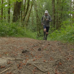
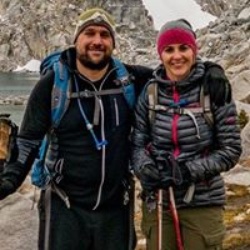
This was a great hike w Kate and Kayleen. Some flowers and we were in and out of the sun.
★
★
★
★

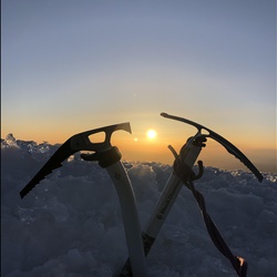
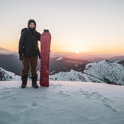
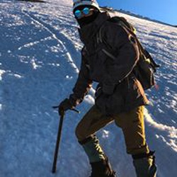
Epic day. Rode bikes with pack, skis, poles, and boots up to Cloud Cap. Then donned skins and headed up the Snow Dome. Ski down back to Cloud Cap, the. Rode back to car for a beer and drive back to Portland. Total time was over 10 hours.
★
★
★
★
★

Amazing views at every turn. Truly a magical place. 10 out of 10, minus the uphill but it’s worth it
★
★
★
★
★
Wildflowers at every turn and Mt. Hood in the background. Saw the sunset and sunrise. Everything was perfect. Minus forgetting to pack my tent poles. Wont make that mistake again. But it somehow became one of my favorite parts of the trip. Sleeping under the stars in my tent with no poles was close to perfect
★
★
★
★
★

This is an incredibly special trail with perhaps the best views I’ve ever seen in 8 years of hiking around Mt Hood. The final 2 miles make the challenging lead-up more than worth it.
But be warned the trail is in bad shape when breaking off the main trail shortly after Ramona Falls. Dozens of downed trees and sections of the trail that have been damaged/ destroyed.
The best spot for water before camp sites is a stream to the right as you hike up - shortly after a stagnant pond on the left. The stream’s water taste amazing (after filtering) and is a delightfully cool temperature. It’s still several miles from camp spots, so be prepared to fill and carry 4+ liters from the creek as you likely won’t get another water source until you come back down to that stream.
All-in-all, this is an amazing and grueling hike that requires some planning to avoid injury or dehydration. Well worth it
It would be 5 stars with just a bit more trail maintenance
★
★
★
★

Great views of the mtn, flowering meadows galore, lots of water but nothing hard to cross. This is an easy out and back for a dayhike or overnight with pretty easy gradients. The only bit of challenge is the ascent from Zigzag cyn eastbound if you’re in mediocre shape.
★
★
★
★
★

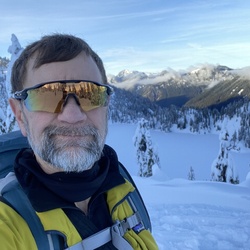
Fantastic skin and ski above the Palmer chair. Who knew we would spring ski conditions in February!? Time for more winter!
★
★
★
★
★

 stars
stars
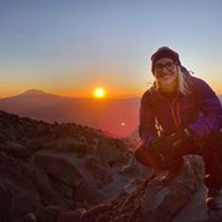
Stunning sunset from our Dollar Lake camp. Beautiful early fall hike.
★
★
★
★
★

Very hazy/smoky and windy so I turned back just above the shelter. Ash leaves have beautiful fall colors.
★
★
★
★
★


Nice trail from the White River parking lot to the Timberline Lodge. It was cloudy and raining, will have to try it on a better weather day!
★
★
★
★
★

Beautiful hike with bright fall colors. 10 in lot
at 9am. 23 in lot that holds 12 at 3:00. Very busy trail. Went left at lollipop where there is plenty of water to filter Then onto McNiel shelter and retracted trail to avoid scrambling. I recommend going on the north side of Bald hill on the outbound and south side returning because the light will allow much better photos
★
★
★
★
★


road to get to camp pretty rough. pot holes and rock. 1 hr 10Mile drive from hwy
wonderful views. make tie-in rock your destination. up on ridge. can almost see at switch backs. hike they say is difficult. not really. as long as your legs are in shape
probably have to wait mid summer for road closure to open. 2 dry pay camps near trail heads
★
★
★
★
★

Not for first timers! This hike can be extremely difficult. Many river and creek crossings that are be dangerous. The views are indescribable, pure beauty. This hike is the one I am most proud of to date.
★
★
★
★
★
Beautiful time of year with sweeping views and little to no smoke. Last 9 miles of road are bad and get worse as you go. I have 8in clearance and that was great. 12 cars at trailhead at 1pm.
★
★
★
★
★

Gradual ascent to great views of N side Mt Hood. Kind of the perfect hike. Started late which put us in fully exposed area at heat of day on first day of heat wave. Only made it 3mi in before had to turn around. Dog was really struggling in the heat. Otherwise, great hike.
★
★
★
★
★

There were TONS of people here. The amount cars parked on either side of the trailhead was kind of unbelievable.
Most people were friendly. One antisocial person was smoking a cigarette on the trail (boo). Someone else left a #2 and TP off a side trail (don’t do that!).
It was quite hot and dry and there were a million flies.
Overall, I enjoyed it, especially the view of Hood from Bald Mountain, but I might suggest avoiding summer weekends, especially on sunny days.
★
★
★
★
Timberline Trail around Mt. Hood with Matt Mason. Paradise on earth.
★
★
★
★
★
A good safe workout. However is was very firm.almost ice. About an hour drive from the VRBO in Lyle. Kanyon, Sara, Amber and i skinned to the top of Palmer lift and skied back down. Laurie and Brooke and the dogs walked around in microspiks. Toured the timberland lodge. And we went to the Mt Hood brewery and had very good pizza. Great d’y
★
★


A great loop that takes you through a variety of landscape and skill levels. Not sure how anyone can rate this hike one star - there are a few - maybe wanting a Disneyland experience but didn’t get it.
★
★
★
★
★

A classic Mt. Hood hike. I started from the McGhee Creek trailhead (much less crowded than Top Spur). The trail is pretty overgrown until it meets up with the Timberline Trail 1.7 miles in but no problem following it. I chose to go up the more direct "McNeil Point Scramble Trail" to the shelter. That cuts off about 1.5 miles but it's called a scramble for a reason. It is steep and exposed in a couple spots. I definitely wouldn't want to go down the scramble trail, so I didn't. I took the conventional route down making a loop out to the north by Gilsan Creek. The wildflowers were still in full bloom and I sat by the creek amongst the flowers for lunch. A beautiful hike.
★
★
★
★
★

Today was overcast and cool after a string of hot days. The wild flowers were beautiful and the greens were excellent. Dusty as one would expect.
A perfect day for so many reasons
★
★
★
★
★


Not too hard, lots of shade, lake w comfortable water temp and stunning view of mt hood.
★
★
★
★
★

We hiked to Ho Rock as part of our day from Lolo Pass trailhead. I definitely wouldn’t call the section easy, though it’s not very long it is quite steep with some slick sandy areas. Definitely not for someone with vertigo! Great views though!
★
★
★
★

Long but not extremely difficult. The way back to the parking was actually the most strenuous given how long it is. Nice varied scenery.
★
★
★
★

Did this as part of the Timberline Trail previously and wanted to see it again. The only real challenge was the river crossing. Beautiful.
★
★
★
★
★

Absolutely loved this hike! Our new favorite. Perfectly challenging, beautiful start to finish. Loved it!
★
★
★
★
★

Great hike, not very busy for July (only encountered 2 parties on my way back and none on the way in). The further in you go the worse trail maintenance gets. At some points it’s impassable without without scrambling over some very large felled trees.
If you want to summit The Pinnacle, I high recommend approaching from the south. There’s no trail leading up to it so it’s a hard slog over fields of rock shale and dense rotting or rotted trees. The north approach is the most direct but 50-75 ft from the summit it’s almost a straight vertica climb up volcanic rock. From the south it’s much more gradual, though the inclines still far exceed 45 degrees. Then the final 20 is a scramble over some boulders.
Amazing views from the top though.
★
★
★
★


Not too long of a slog to some really good spring conditions today
★
★
★
★

really beautiful hike, was very long and sunny but worth seeing the waterfall at the end. it was nice to use our filter and drink some clean glacier water. was an overall really fun and beautiful experience.
★
★
★
★
★

Did the route counter clockwise to get steep section done first. Trail to steep section is unmarked and would be hard to follow without GPS. Encounter snow on steep section up to McNeil Point and halfway down going back to trailhead. Did not go to Ho rock because of snow. Saw a Bear track in snow on the down.Great views. This will definitely be one of my repeat hikes.
★
★
★
★
Beautiful hike. Did the loop counter clockwise to get the really steep section done. The trail to steep section is unmarked and without GPS would be hard to follow. The rest of the trail is good. Snow starting on rocky section to McNeil Point and halfway down returning to TH. Did not go up to Ho Rock because of snow. Will definitely be redoing this hike.
★
★
★
★
stars
Crystal clear day brought amazing views of the surrounding mountains, including Mt Jefferson to the south. We day hiked on Friday and the parking lot was nearly full when we left with backpackers heading to Burnt Lake for the weekend, even in late Sept.
★
★
★
★
★

Complete Timberline route imported from HikingGuy.Com gpx file. Actual total elevation however is ~10k feet, not 15k as listed on the route data… not sure where the 5k difference came from. Total loop in 42 miles, not 40. This file includes the necessary reroutes from the 2020 Labor Day storm (which are not very obviously marked on trail signage).
★
★
★
★
★

This hike was beautiful! It had everything I look for in a hike. It had beautiful views of Mt Hood and the waterfall. It also had nice forest on the way back from the loop with nice water sources. We even saw a fish swimming in the creek. The water crossing was not bad at all either.
★
★
★
★
★

This is a great hike! Very scenic the whole way and tons of nature. The ascent is gradual and easy. The waterfall is beautiful and well worth the trek.
★
★
★
★
★
Great snowshoeing. Beautiful views of Mt. Hood. On clear days great views looking north toward mounts Adams, Rainier, and St. Helens.
★
★
★
★
★


This is a pretty cool hike good elevation pretty consistent. Not a lot of people once you get up to Palmer base. And you can go pretty high up as long as the winds aren’t that strong. Just pay attention to the weather because it changes by the second.
★
★
★
★
★


Challenging stream crossings at Eliot and Coe branches, and long stretches of switchbacks getting to them, balanced out by amazing views of Mt Adams, St. Helens and Rainier.
★
★
★
★

A beautiful hike during the summer months. Trails are usually busy but not so much that it impedes progress. Some downed trees over the trail in certain sections but nothing impassible
★
★
★
★
★
stars
Backpacked this loop at the end of July. Flowers were in bloom and sunset views amazing.
★
★
★
★
★

Great trail and views. Running water in Zigzag River in early September. Was just a bit crowded.
★
★
★
★
Very easy river crossing. There’s a log with another log for hand rails. Come back on the PCT side to avoid the only “climb” of the hike if you don’t mind the downhill. Otherwise it’s a very easy hike.
★
★
★
★
★


Just linked some features together on the east side of Mt Hood. Wanted to do Cooper Spur in addition, but I was pressed for time. The wildflowers are beautiful right now, would recommend hitting it early, there’s no shade on the Timberline Trail as you can expect.
★
★
★
★


Started at parking lot and came 9.5 miles so we are close to falls, but at great campsite. We were hiking in the clouds for a few hours so we couldn’t see Mt Hood, but absolutely beautiful scenery. The water crossings were easier than many suggest. Yes, you need to be careful at one, but look around and you’ll find a spot. Camp site is stunning. We went to the second one out of the three areas and it is closer to river. I could see in high water times that it could be swampy though. Excellent hike, glad we came!
★
★
★
★
★
An absolutely amazing hike. The falls, river, mountain truly showed their beauty. Went as far as we could due to crummy conditions. Just shy of making it all the way. Would highly recommend to anyone looking for a hike to challenge themselves with miles. Elevation gain was not bad all. Beware of numerous fallen trees in the path. Some junction signs are in need of replacement and could be deceptive to hikers not familiar with the are.
★
★
★
★
stars
Hiked up to Bald Mtn from Lolo Pass, east on the Timberline a couple of miles and then back down McGee Creek Trail. While likely not the best season for this hike, it was a beautiful forested hike with great views. The trail was in good shape and easy grade. There are many huckleberry bushes, so a late summer hike might find these fruiting. Due to clouds, our view of the Mt Hood peak was blocked.
★
★
★
★
★
 stars
stars
Able to all of the nearby Peaks given the clear skies, there were people but not a ton and not everyone hit the top due some snow.
★
★
★
★
★

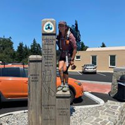
A historic trail. Trail head begins at Timberline Lodge.
Trail takes you around the mountain for 57 miles at the 6,000 foot level in Wilderness country
★
★
★
★
★

I’d rate this 4.5 if I could. Parking at Timberline lodge was easy. There were many hikers on the trail. If you use All Trails for trail discovery and research—it’s very good for that—their info is way off, as usual. This particular hike is not yet listed in Gaia (not sure why, it’s a popular hike). I used two GPS devices and measured approximately 13 miles (not including long walk from and to the parking lot). And, measured ~3,100 ft elevation gain. Also, this hike is not that hard, don’t be intimated by the All Trails description. I’ve done hard trails before, and this is not hard. On a difficulty scale of 5, I’d rate it 3.5 due only to length and moderate elevation gain. This definitely is not an easy hike, but it’s also not hard. There are some muddy, slippery spots, some steep drop offs, and one creek/river crossing that may challenge some people—my balance isn’t great, but with the help of hiking poles, I made it across both times with little problem and without taking off shoes. Overall, this is a great hike, very scenic. I’m a fairly fast hiker, it took me about 4.5 hours, and I stopped multiple times for pics and several times for water and food. If you’re concerned with the distance or elevation gain, start early and give yourself plenty of time. It’s worth it!
★
★
★
★

Quintessential PNW beauty. Walked along the PCT right below the timber line, then looped around above the trees thru Paradise Valley - an area of alpine meadows full of spectacular wildflowers. Waterfalls and creek crossings so there’s available water. Challenging in distance but overall not too difficult.
★
★
★
★
★


The snow melted earlier than usual and our hike 7-22 was just after most of the snow was gone. The flowers were in full bloom with meadows filled with Alpine lilies, lupine, paint brush and at least 30 different types of flowers. Good patches of tiger lilies and Washington lilies. The trails were clear and with a sunny day the views were excellent.
★
★
★
★
★

Beautiful hike. Started at LoLo Pass. One draw back was the potty stop on the woods across from the trailhead was full of paper. Please if you must use paper put it in a zip lock bag and deal with it appropriately.
★
★
★
★
★
A trail that does not see a lot of use. It’s a long uphill climb under trees, with a view of Mt Hood on an open slope just beyond 5 miles. Continue on to Cast Lake for camping or to the East Zigzag peak for great views.
★
★
★
★

It was cloudy out, but still a very enjoyable hike. The beginning of the trail was wide with a park like vibe. As we climbed to the lake the trail crossed many small streams in forest and meadow settings. There were a few muddy areas, but they were easily crossed by rock hopping. Near the first large stream crossing we met a backpacker (with a shotgun strapped to the top of his pack!) that warned us of a bear in the area moving upstream. No sign of a bear, but we were on high alert through the area. Burnt Lake itself was wrapped in low clouds that obscured Mt. Hood when we arrived and we chose to push on to the top of East Zi-Zag for our lunch break. The climb went by quickly with views opening up at the saddle near the summit. To treat ourselves for the climb we enjoyed cups of rosé and cold(-ish) pizza in the clouds. The way back down was mostly uneventful, but still enjoyable.
★
★
★
★


 stars
stars