Hike up to the pools. There was a small waterfall at the top of the pools.
★
★
★


Steady grade. Loose rock all the way. Transitions from chaparral to low oak- juniper habitat.
★
★
Steep and rocky. Great views. The trail as obvious - as far as I went - as opposed to other reviews.
★
★
★
★

Hiked with two dogs on loop trail. Couple scrambles off on some
Intersecting trails increased the length.
★
★
★
★
★

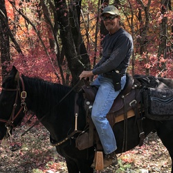
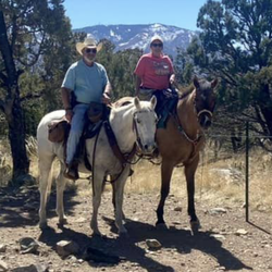
Great ride. Arizona trail is beautiful on the section we rode out of Hay Creek Ranch 13.8 mile loop.
★
★
★
★
★

Awesome views, pretty casual hiking, small scramble at one point but nothing hard. Dog friendly and doable at a walking pace in under an hour and a half. Highly recommend.
★
★
★
★
★

Great trail. Rated a 7 out of 10. 2 big obstacles. Need to be spotted
★
★
★
★
★

Started just before sunrise. Only person on trail entire time. About 50min up. Jogged back down. Explored a bit at the trail end. Gaia Topo shows a split trail near the end that doesn’t exist.
Windy at top once the sun came up. Beautiful views.
★
★
★
★

Rating should be “difficult” rather than moderate; it is very rocky around a number of peaks. Some areas are very narrow and steep. I personally didn’t find the pools very alluring, but my buddie really wanted to treat herself to water here in the desert.
★
★


I hike this route every year at least once. I come up using this route but take the Super Trail all the way down. It adds a couple of miles but the solitude and cruisey trail are well worth it.
★
★
★
★

Excellent hike. Beautiful weather, 64 degrees to start. Rain had ended & the forest was sweet. Cool fungi! Tough Kent springs ascent. Good stretch from ‘shovel saddle’ to pine saddle via user trail, minimal bushwhack.
★
★
★
★
★

Enjoyed. Challenging. Beautiful. Lots of shade. Signs for distance are wrong. 700+ ascent in 1.5 miles from the ski lift.
★
★
★
★
★


I love these SE AZ peaks. Trail is well maintained the entire way. Gorgeous views the whole time.
★
★
★
★
★

The deep pools of water near the top of the hike made this a spa day for my dogs! Great hike!
★
★
★
★


Beautiful winter hike on an impeccably designed trail. 1000 feet up without feeling it.
★
★
★
★
★

Breathtaking views, unique Madrean oak woodlands, unbelievable rock formations and moderately challenging hike. I would through to the west side over the divide next time!
★
★
★
★

Decent enough trail, not technically challenging at all. You could do it in a high clearance Subaru. Although I did very end of the trail, they just dead ends. There must’ve been a landslide or something because you can’t get all the way up to the China peak.
★
★
★

Easy trail connecting Cathedral View to the smaller campgrounds.
★
★
★
★
★
Narrow, rocky trail and about 3,000 feet of elevation. The views from the top are great.
★
★
★
★
★
This was our favorite hike in the Coronado National Forest. We saw the dam on Cave Creek built in the 1930’s by the CCC, and hiked to a higher elevation for great views of the vast National Forest and beyond to San Simon Valley. We saw bear scat at numerous points along the trail.
★
★
★
★
★

Trail is mellow for 1.5 miles meandering along a creek but not far from traffic on a road. Then after crossing under a culvert it meanders next to a dirt road (less traveled and you can select several trails at a junction and we went up Mt. Bigelow trail a ways where it gets moderately steep but still shaded in the trees. Great cool shaded hike and for an early season hike to get your legs going.
★
★
★
★

Beautiful loop. Vistas. Streams. Not too many birds. Do Not park by the potty/trailhead. Park up above.
★
★
★
★
★

The destination is the reward. Very rocky and over 1,000 foot elevation gain makes it challenging. Worth the rocky climb to see the pools and spend some time there. I’m my opinion, should be a “difficult” not “moderate.” Must do early in the morning. Gets hot quickly.
★
★
★
★
★


It was tough I’m almost 80 with bad knees lots of rocks and up and downs but man oh man what a beautiful hike the pools at the end were worth it best of all I did it
★
★
★
★
★

Beautiful, crisp clear morning with snow on the ground, but trail mostly clear. Probably a good early summer hike starting at 5400’.
★
★
★
★

Great Mtn bike around the lake. Approx 4 miles. Some hike-uh-bike but 90% bikable. Very narrow trails. Fun and gorgeous area. Very few people too.
★
★
★

Ventana Canyon to Maiden Pools is a fine hike with many stream crossings, currently. I was able to jump across and rock hop all of them without getting my feet soaked. The flow, when much higher (which occasionally happens) can include many wading crossings. Usually it is a dry creek in this beautiful canyon. Maiden Pools, just a quarter mile beyond the top of "Cardiac Hill" with all its switchbacks, is a great place to sit by the pools of water in sheer rock (banded Catalina gneiss), or to take a dip in bigger-than-bathtub pools.
★
★
★
★

Trail not maintained 10/30, impossible to follow. Walked through the desert and into all its stingy, pokey plants:) Wear pants, bring a machete, moderate rock climbing to get to the top. Beautiful view.
★
★

This was one of the most challenging hikes I’ve ever done, and I’ve done some pretty challenging hikes. The trail is incredibly overgrown for about six miles until you get about two miles away from the top. And the foliage was often thick bushes with thorns that would grab onto your clothes. Often the trail was completely invisible and there were sections that were impassable without crashing through thorny bushes or clambering over boulders or walking up steep slippery terrain. I’m glad i did it, but way more glad I’m done. If you do this, make sure to leave yourself a lot of time. For about six miles it will be hard to go faster than 1 mile an hour
★
★
★

Hiked this trail in early November and the weather was perfect! Great views along the trail, but watch your step because it is very rocky in places. I expected this was an easy hike to convince my wife we should hike more...not so much. She did it, but we were both tired at the end (round trip of course: 5.7 miles). I'm new with Gaia so I didn't know to record it. Bummer!
★
★
★
★
★

This is a fun hike above Sabino Canyon. I never found it difficult, but have not hiked it in fifteen years or so. Maybe I would have a tougher experience now. The views are great. You will go through a lot of water, and temperature can range from hot and sunny during the day to cool or cold in the late afternoon, depending on the time of year. Do make sure you are in reasonable condition and have good balance or walking sticks. It’s not overly demanding, but it’s not a good place for an injury. Bring windbreakers, sunscreen, and hats. And water! Enjoy.
★
★
★
★
★

Beautiful canyon drive, steep drop-off, gravel road. Moderate amount of people during mid-day.
★
★
★
★
★

I love these rock formations in the Dragoon Mountains, they are very unique compared to the many formations of the desert. Great trail roads going in are marked ok. I only went as far as the springs. Looked like there’s a lot more!
★
★
★
★

This was an easy to moderate 2.5 mile hike for me. It was an hour out and an hour back. It was never very steep. The Welch Seep itself is quite uneventful but the trail has gorgeous views all along the way.
★
★
★
★
This was an easy to moderate 2.5 mile hike for me. It was an hour out and an hour back. It was never very steep. The Welch Seep itself is quite uneventful but the trail has gorgeous views all along the way.
★
★
★
★


Really cool rock formations. Trail wasn’t hard to follow. A little overgrown, but not an issue. Found some pools of water. Neat hike.
★
★
★
★

I had a really great hike up then saw adult and cub sets of cougar tracks in the snow. Decided it was time to turn around.
★
★
★
★


Good trails. Agua Caliente saddle was a bit overgrown. Recommend watching the weather report very carefully in Monsoon season. We took a chance that we could clear the area in 3 hrs and were caught by a heavy afternoon downpour. It was our fault, but we weren’t the only ones caught on the trails. GAIA map download helped as the rain runoff was masking and making it difficult to locate the previously marked trails/path.
★
★
★
★

Hot, dry, of course it’s June in AZ. Trails VERY rocky after Josephine Saddle.
★
★
★

I only went about a mile in before it got too scary for me. I would rate this at the edge of Moderate, and I’m strictly an Easy hiker. (Age 64 with bad knees and ankles.) Many burned or partly burned trees, but many more are undamaged.
★
★
★
On the moderate edge of Easy, which is as rugged as I can handle. Many burned a partly burned trees, but beautiful for all that. There is some scrambling over rocks, and walking next to a steep drop.
★
★
★
I had limited time so I didn’t get as far as I’d like. But the part I got to was cool and beautiful as nearby Tucson had another day of record heat. An easy trail with some elevation gain. Not crowded unless you count the birds in the trees. I’ve been here a number of times for fall leaves, and I’m happy to say the summer green is just as pleasant. I’ll be back to follow the trail further.
★
★
★
★

Excellent vistas both up multiple canyons and down to the city. Great number of saguaros, however up past cardiac gap the extensive fire damage from 2020 is the worst I have seen - sad, but much green still remains if you make it to Geronimo meadow and up. Totally worth the trek, shaded in the early morning, some steep crag sections, and passes through washes that likely flow during monsoons - fun trail to navigate both up and down.
★
★
★
★

Fun and beautiful hike! A good amount of coverage to hike comfortably in the summer. Dog friendly and not too rocky for their paws!
★
★
★
★
★
Fun and challenging loop. Start early to get parking and to see the wildlife before it gets scared away. Started at 7 and finished at 11. Hiked at a moderate pace but took time to top and enjoy the views on high points as well!
★
★
★
★


Beautiful hike starting at the bottom and making our way through very scenic overlooks. Eventually made it our way into the trees and down into the valley into a parking lot next to the Catalina highway. We left a car at the top so we could drive back down to the bottom. Did it in 2 1/2 hours.
★
★
★
★

Not much elevation gain, but challenging and atunning trail nonetheless. Takes you right to the foothills of the mountains, through desert streams, and into the mouths of canyons
★
★
★
★
Scenic hike, moderately challenging. Be prepared for a few rock scrambles, and a few parts where the trail is hard to find. The trail runs from a parking lot to a set of cabins up in the mountains. The view is anput a quarter miles from the cabins
★
★
★


Great and beautiful hike! Trails good and not too rugged
★
★
★
★
★

Attempted hike in early March. Snow, ice, and mud at the 1 mile mark made us turn around.
★
★
★


The drive was easy no need for a 4x4 the view is amazing overlooking the USA Mexico border wall
★
★
★
★

The first 4.5 miles are a nice hike. The trail is in serious need of maintenance from about 4.5 miles up to the Mt. Lemmon trail. Very steep and difficult.
★
★
★
★
★


Easy to moderate hike depending on your level of fitness. Stunning rock formations. 6 miles round trip is not too difficult.
★
★
★
★
★

Behind zip line up fire break, ride ridge line, down hill through gate, to miners grave trail bear canyon, road. Stay on road............home
★
★
★
★
★

Hiked with Sheri on a very nice Mid December day. The trail is steep but the turn to Dinger Rock is cairned very well. Some fun scrambling.
★
★
★
★
This is probably the most dramatically beautiful hike I’ve taken this year, certainly within my “easy” ability level. The steep hill at the beginning is amply rewarded with towering mountain peaks, meadows, mesquite forests and an actual canyon to descend into. There are even benches in several places, the better to stop and enjoy the view.
★
★
★
★
★

 stars
stars
This was the most difficult hike I ever did. However, the best views come after the hardest climb and this proves it. I took the old Balt trail up and the super trail on the way down. A lot of times I was thinking what did I get myself into but I loved it at the end and will definitely do it again!
★
★
★
★
★
Bog Springs Trail was too rugged for me, so I ended up having king the road, plus the trail from Santa Rita Lodge back to Amphitheater. I saw 4 deer (3 sightings) and lots of turkeys.
★
★
★
★


Wonderful and difficult hike but drought is starting to show. Some widlflowers but I have seen many more. Pretty hot hiking below Josephine Saddle in the afternoon.
★
★
★
★
★


Very beautiful hike. The challenge getting up the mountain is worth it once you see the views. I would disagree that this is an easy hike. You have about 1000 feet of climb which at the altitude was challenging at times. The trail was is good shape....definitely recommend this hike.
★
★
★
★
★

This was just a piece of the Madera Canyon Nature Trail, about a mile and a half each way because that’s what I had time for. It’s reasonably easy, is cooler than most Tucson-area trails (excluding the fire-ravaged Santa Catalinas) and has a variety of often spectacular views.
★
★
★
★

Easy, scenic drive through a variety of desert landscapes. Start in Oracle, then up the back road to Mt Lemmon. Down the mountain into Tucson and for Tanque Verde Road to Redington Road. Continue north into Mammoth. Stop at La Casita for some really good Mexican food!
Dispersed camping available on the back road to Mt Lemmon.
★
★
★
★

Nice trails that led to a creek, cutting through the rock. Still had water in in end of May.
★
★
★
★
Excellent area for biking, hiking, motorcycling or whatever.
★
★
★
★
★

Amazing up the gully. Go till the obvious large slot canyon and waterfall.
★
★
★
★
★


5-2-2020: Due to the Horseshoe II fire of 2011, the trail from Barfoot to the Pine Canyon Falls is in poor shape. Starting out, there are numerous downed trees to contend with. Later, downed trees are less frequent, but encroachment of small thorny bushes make hiking in shorts very uncomfortable. We turned around after about 1 mile. There is a nice park about 3/4 mile from Barfoot in which we enjoyed lunch. Other than that, the trail is, unfortunately, not worth the effort right now. Conditions are being reported to the FS, but the manager has said that funding is very limited for trail maintenance at this time.
★
★

Awesome hike but u need to start earlier then we did. Spectacular view and a nice Pool of water at end. Recommend this to all.
★
★
★
★

Great Dirtbike route. Falls are amazing. Pretty technical on a dirtbike with some really fun climbs.
★
★
★
★
★

It’s was both an educational experience and a pleasant hike. The historical ruins of a Hohokam village and the dwellings of an 1850 rancher named Romero are worth seeing. The site includes informative signs along the path. The Hohokam lived in the area continuously from around 500AD forward.
I hiked in April and the desert vegetation was a lush green. There were several small streams and pools along the trail. The streams are temporary however and cannot be relied upon for water.
Be sure to wear plenty of sunscreen and a good hat for shade. Most importantly bring plenty of water especially when the temperatures begin to rise.
★
★
★
We had a flat tire on the rear wheel and that sort of spoiled the trip.
★
★
★
Awesome easy hike with plenty to see and admire even if it’s outer trails pass along homes.
★
★
★
★

16 dry creek crossings
beautiful flowers!
Light traffic.
Parked overfill outter lot
★
★
★
★
★

Hiked from the amphitheater parking lot counter clockwise around the loop. We found that route to the Kent Spring to be steeper. On the other side of the loop (north side) there were a few switch backs that made the trail less steep. The north side trail had more openings in the forrest to enjoy views of the surrounding area.
★
★
★
★


Not very strenuous, but multiple nice views of lakes and a good way to get back into hiking. Peaceful and relaxing lake in the middle of a dry desert.
★
★
★
★


This was an excellent mid afternoon hike on a warm December day. Water still was flowing after recent winter rain we had received. I didn’t complete the hike as I ran out of daylight, choosing to bushwhack back up to the road (371) and hike back down to where I had left my car, enjoying the sunset and listening to the whooping, car horns honking and laughing of the usual Redington Pass nightlife starting up.
★
★
★
★

Moderate rocky climb. Best in cooler weather, and when water running.
★
★
★
★

Very fun hike. Beautiful view at the top and just nice area to be in.
★
★
★
★
★


Amazing Nature, breath taking views, must see place.
★
★
★
★
★


This is a very nice and scenic hike. I began just before sunrise. The air was very chilly, but as soon as the sun rose above the mountains, the temperature warmed up quickly, but was still comfortable in late morning.The landscape was surprisingly lush and verdant, owing to significant rainfalll in October. Numerous plants were in bloom, making for a very aesthetic hike. Visibility was excellent in mid-autumn conditions. - I had hoped to sight a Big Horn Sheep, after seeing numerous signs about them, but came up empty. I did spot a Gila Monster, which was the highlight of my day. The Romero Pools are situated about 3 miles from the trailhead and are beautiful. If you hike another 0.3 miles, you will encounter another set of pools.
★
★
★
★