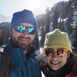
Staggeringly stunning.
The climb is no joke but the reward is sooooo worth it.
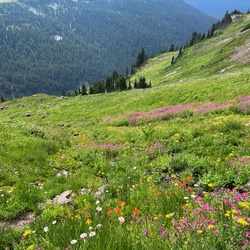
Pick a clear day if you can as the view from the lookout is 360°s of mountains.
★
★
★
★
★


To call this a trail is to give trails a bad name. Three quarters of this hike was in dense, 5-7 foot brush. Add in the 2,700’ elevation gain over 11 miles on a warm, humid day and you have a literal hiker hell.
★


Had to get my game face on for this one. Challenging mentally and physically especially as a solo hike. Easy to lose track of the “trail” at times especially between box creek and freeze pass. Sketchy, loose traverse. But the fall colors are epic!! And surviving a challenge always feels like a big win. Highly recommended for the more skilled/advanced hiker.
★
★
★
★
★


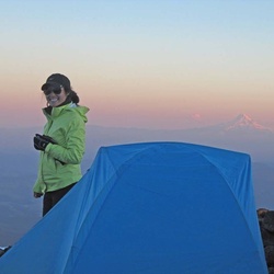
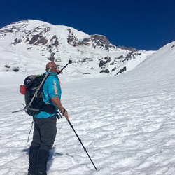
Glacier Peak is amazing! A formidable mountain at over 10,500ft. Includes roping up for glacier travel if you want to summit. This route was 50 miles in 4 days and covered a beautiful section of the PCT. In early September the bugs were there in places, but not terrible. Highly recommend if you are looking for a challenge!
★
★
★
★
★

Quiet day on the trail. Quite a few fallen trees but the trail was in pretty good shape. We had bootprints to follow which helped a lot but had to do a little bit of scrambling the last half mile or so.
★
★
★
★
★


Hard to judge this section of trail. I was too focused on my sore ankle to really enjoy it. The mountain rivers and waterfalls to the west of Buck Creek are pretty. It looks like we were about two weeks early for the flowers on Flower Dome, but it was still pretty. A trail maintenance crew had cleared a section of the trail near the end, so that section of the trail was not as difficult to navigate as the first part of the loop. The trail dust on the miles of burned section of the trail was not fun. It made me wish for a mask, especially being 6th in our procession.
★
★
★
I don’t recommend this particular route. It was an out and back that got us to 50+ miles on our adventure. We ended up traversing the same section of trail three times during the trip. The view from Lyman ridge is great. I recommend doing it on the way through Cloudy Pass. You get a fantastic view of Lyman Lakes and Spider Gap.
★
★
★
★
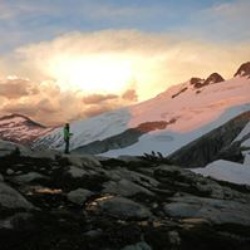
Seeing Spider Gap that we had come through the day before from the Cloudy Pass was very rewarding. The rocky trail from Cloudy Pass to Suiattle Pass is neat, and the scenery is beautiful. There are great views of Glacier Peak from the trail to Image Lake. Image Lake is very pretty, and the views from Miners Ridge Fire Lookout are vast. Russ, the lookout, was very welcoming, and we had a nice visit while he showed us his equipment and quarters. If you stop at the old miner’s cabin make sure you explore the area before setting up your tent. There are some tent sites a little higher above the ruined cabin that are better than right at the cabin.
★
★
★
★
★

Currently this is a very difficult trail only because of blow-downs. Counted over thirty from White River trailhead to Boulder Creek trail. Some were massive and challenging with a heavier pack.
★
★

On the way to the TH, I encountered a Moose, and on the trail I sighted a Pacific Marten. This was my second time being Golden Larches. This is unforgettable views.
★
★
★
★
★

Rough , steep and exposed up from spider meadows to base of spider glacier.
North side of spider gap is scree and very steep.
★

An absolute barn burner to try and do in one day. Doable, but not recommended. This area is too beautiful to be sprinted though in less than 2-3 days. Plus, many areas on the “trail” once you enter the volcanic rock/glaciated section of the mountain are just loose rock and talus. Slow going when you’re already exhausted!
★
★
★
★
★

This hike is awesome. The elevation to the meadows isn’t too hard and the Meadow is a beautiful place to camp in. We continued up to Spider Gap. The elevation gain in the first bit is hard but worth it. We hiked up the glacier with just regular boots and trekking poles. Micro spikes would have been nice, but do-able with out.
★
★
★
★
★

Trail is very hard to follow after the cutoff and crossing to the lake. Be prepared for steep bushwhacking. The lake is beautiful and the Rainbow Trout are big. Not recommended for anyone with full backpacking setup. Trail is easier to find coming down. When in doubt, go farther to the Southwest side of the hill when going up to the lake. Good luck!
★
★

Fantastic! Bring bug spray. Most campsites are just starting to melt out.
★
★
★
★
★

Talk about a burner. The trail to white pass is absolutely amazing. Super large Fir, Cedar, and Spruce. Lots of snow still at the top but the avalanche Lily’s were blooming. I left camp, summited in 6 hrs and was back in 11. Decided to head for car. It took me 4.5 hrs to get back.
★
★
★
★

For what it is it's great! It well formed trail meandering beside a river, mostly under canopy cover (making it a good drizzly/rainy day hike) sometimes in view, most often in earshot, peek-a-boo views of Sauk mountain and other peeks in the distance. Good est. campsites for backpackers, one even had a privy. Did see a black bear so be food aware!
★
★
★
★

The White river valley trail is un-maintained. In glacier peak wilderness that means an abundance of brush overgrowth and loss of the trail. Although the trail can be followed fairly easily up to thunder basin, only remnants of the trail can be found beyond that. In most places the brush is so high it’s over your head. You will be pushing through all sorts of vegetation including thistles. Early on in the trail not much beyond the junction with the buck creek trail you can get a taste of minor brushy-ness where the trail is still very visible. However, remember this is only minor compared to what’s past thunder basin. Also, after the last stream crossing as you start to climb, the trail becomes slightly more visible, but it is still hard to follow. We were able to follow it up until a sharp switch back that occurs near a gorge. We couldn’t find that switch so we ended up climbing up the gorge which I’m sure would be a waterfall earlier in the year. It did require minor rock climbing. We ended up exiting the gorge when things became too vertical and continued our climb pulling ourselves up the rest of the way using the densely packed brush. This was the only time I was thankful for the brush. We eventually intersected the trail once again. From that point on until the intersection with the pct it was fairly easy to follow with only a couple narrow and slick washouts on slopes. I and my husband were able to make our way through, but it was one of the most miserable hikes we’re ever had, and one of the most exhausting even compared to our days of 15+ miles with two 2,500+ passes.
★