Easy going! Lots of rocks mid hike but would much rather be going down than up!
★
★
★
★
★

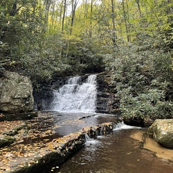
Beautiful hike and gorgeous waterfall with a pool. Lots of elevation gain and can be tricky footing, but worth the trip.
★
★
★
★
★

Note: Camping at the Dragon's Tooth/ BoyScout Trail intersection has been completely closed. There is a camping spot at the intersection of the AT and Dragon's Tooth Trail.
★
★
★
★
★


Excellent hike! My brother and I hiked this together, we go hiking a lot throughout the Blue Ridge and we loved this one. We took a harder (but still easy) route crossing over the first bridge that you see. If you keep going straight it is a really easy big open path. The Cascades is beautiful and seems like a fun place to go swimming in, so pack a bathing suit. We went in late afternoon and didn't see too many people out. Totally recommend if you want an easy hiking day!
★
★
★
★
★


Great bike up powerlines thru the forest trails for a while. Superb mtn biking trails!
★
★
★
★
★

Pocahontas Road in Pearisburg up to the Appalachian Trail and back. Excellent mountain bike route following old forest service roads.
★
★
★
★
★