San Jacinto Peak via Marion Mt Trail
15.1 mi
Distance
7 hrs 11 min
Time
terrain
2,984 ft
Elev Gain
Overview
This is a difficult out and back trail to San Jacinto Peak in San Jacinto Wilderness.
This trail goes by Little Round Valley.
Sights to See
Rate this Hike
★★★★★

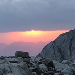
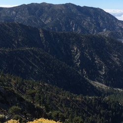
Solo hiked Feb 12 – I had fun doing this loop last year and so I came back for round 2. Started really early and let the trail put me to work as Marion always does all the way up to the PCT junction with great weather and trail conditions. About half a mile before Little Round Valley, it became noticeably colder as usual, but adding glove liners was enough to stay comfortable. Going up the west side of San Jacinto early always feels colder than the east side (Peak Trail) without the east’s early solar warmth (and nice sunrise over the Salton Sea). That said, the west side’s forested terrain has its own uniqueness including the nice overlooks. But I knew I would be on the peak at sunrise before going down the east side so I’d get nearly the “whole package” today. Once on the switchbacks above Little Round Valley, the ice patches became harder to bypass, prompting me to spike up. Snow/ice coverage was uniform halfway up the switchbacks but never too treacherous. Views from the summit were really nice with just a little mid elevation haze/fog in the valleys and a high, stratified cloud celling. While heading down the east side, I was fortunate enough to meet up with Jon King of the San Jacinto Trail Report. After catching up on things and excitedly talking about all the snow in next week’s forecast, I continued on toward Wellman Divide and Annie’s Junction, stopping along the way at Wellman Cienega to filter some nice cold water. The stretch of PCT between Annie’s and Strawberry junctions is very scenic and always a favorite. After a food break at Strawberry Camp, it was a straight shot up PCT and down the Marion Trail to the car. Just before the car, I was surprised to see “Maria” on the trail whom I’ve met on several SoCal peaks. Highly recommend reading Jon’s daily reports at https://sanjacjon.com/ for the latest trail conditions before heading out. Logged 16.1 mi /25.9 km & 5089 ft /1551.1 m with Gaia
★
★
★
★
★