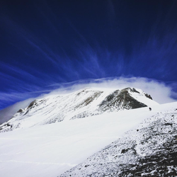
Mount Thielsen via Mt. Thielsen Trail #1456
Overview
This is a difficult out and back trail to Mount Thielsen in Umpqua National Forest.
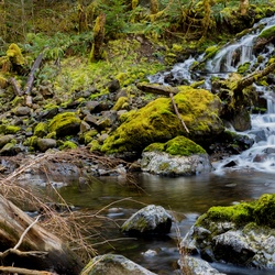
This trail goes by Lathrop Glacier.
From parking lot to summit, this trail is a little over 4.5 miles. Over that distance, you will gain ~3,170 ft. The first 3.5-4 miles are moderate, taking you through fairly gentle switchbacks. The views of Diamond Lake and Mt. Bailey continue to improve with elevation, and you will traverse through burned areas (popping with wildflowers, depending on the season!).
The official trail will terminate at the intersection with the Pacific Crest Trail. From there you will have excellent views of the peak, Diamond Lake, and Mt. Bailey. If you wish to summit, follow the well defined social trail past the intersection with the PCT. After some short switchbacks along a rocky, exposed ridge, you will start ascending the west/southwest facing talus slope. This has many switchbacks through loose gravel that become less defined as you gain in elevation. This is a very difficult trail with no shade or flat sections.
The last 80 feet to the summit is not advised in icy/snowy conditions. Many people decide to bring rope and harnesses, which is definitely a smart option if you are not a confident scrambler. The spire is exposed on all sides, with the northern face dropping down to Lathrop Glacier. Know your abilities and use good judgment when attempting this summit.
Getting Started
Park at the Mt. Thielson Trailhead parking lot, which is on the right if you are heading north on 138. It will be shortly after the intersection with 230. The trailhead is just past the pit toilet. You will need a Northwest Forest Pass or inter-agency access pass to park. You can also pick up a $5 day pass at any Forest Service ranger station (the closest being the Toketee Ranger Station).
Taking Children
The official trail is of moderate grade and has decent shade. Children would likely do fine with breaks. Summitting (past the intersection with the PCT) with children is NOT recommended, due to steep drop-offs, loose footing, lack of shade, and difficulty of incline.
Rate this Hike
★★★★★

 stars
stars


Public Tracks