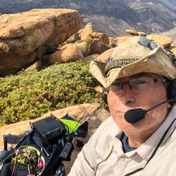
United States
›
South Dakota
›
Black Hills National Forest
›
Crow Peak

Crow Peak(edit)

based on 7 tracks & routes   |   |  
MODERATE
   #16 hike out of 777 in Black Hills National Forest   |   
MODERATE
link Copy Link
  • facebookFacebook
  • Twitter iconTwitter
  • emailEmail
directions Driving Directions
  • GPX
  • KML

3.2 mi
Distance

1 hrs 26 min
Time
terrain
1,526 ft
Elev Gain

Overview

This is a moderate one way trail to Crow Peak in Black Hills National Forest.


    Rate this Hike

    ★★★★★


Public Tracks

user_profile
Tiffany 1 year, 4 months ago
Crow Peak
Gradual, wraps around peak
user_profile
sheila_77 1 year, 11 months ago
Track (5/30/20, 10:22:16AM)

Elevation Profile

Seasonal Popularity

Nearby Hiking Trails

  1. 1
    Spearfish Falls via US 14A
    ★ ★ ★ ★ ★ DIFFICULT 18.5 mi
  2. 2
    Beartown Hill via Higgins Gulch Road
    ★ ★ ★ ★ ★ DIFFICULT 31.5 mi
  3. 3
    Spearfish Falls via US 14A
    ★ ★ ★ ★ ★ DIFFICULT 18.3 mi
  4. 4
    FSR 130
    ★ ★ ★ ★ ★ EASY 1.4 mi
  5. 5
    Higgins Gulch Road
    ★ ★ ★ ★ EASY 5.0 mi
  6. 6
    Iron Creek Lake via Tinton Road
    ★ ★ ★ ★ DIFFICULT 25.2 mi
  7. 7
    Aspen Hills Road
    ★ ★ ★ ★ EASY 1.5 mi
  8. 8
    FSR 626.1K
    ★ ★ EASY 1.5 mi
  9. 9
    Higgins Gulch Road
    ★ ★ EASY 2.9 mi
  10. 10
    FSR 130
    ★ ★ EASY 4.8 mi
  • Web App

    • Map
    • Find Trails
    • Upload
  • Resources

    • Hiking & Backpacking
    • Offroad
    • Hunting
    • Mountain Biking
    • Backcountry Skiing
    • Fishing
    • Map Catalog
    • Help & Forums
  • Purchase

    • Individuals
    • Professional
    • Outside+
    • Volunteer
    • Gifts
  • Company

    • Blog
    • Podcast
    • Jobs
    • Diversity
    • Partnerships
    • Media
  • Gaia GPS - Trail maps for every adventure

    Follow Us

    Download on the App Store Get it on Google Play

© Trailbehind Inc. - All Rights Reserved.

  Privacy • Terms

Outside Inc Logo

© 2022 Outside Interactive, Inc.

Outside Inc Logo