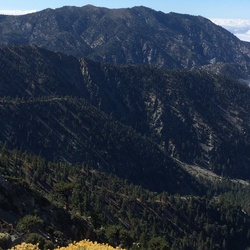
Grays Peak via Gray's Peak Trail 1W06
3.4 mi
Distance
1 hrs 37 min
Time
terrain
1,143 ft
Elev Gain
Overview
This is a easy one way trail to Grays Peak in San Bernardino National Forest.
This trail goes by Yellow Post 1.
Rate this Hike
★★★★★

Solo day hiked Weds 12/27/23 – Grays Peak, Butler Peak Lookout, Hanna Rocks. Wanted to go up Grays Peak so I had to take the back way as the Grays Peak Trail is closed for Jackie/Shadow and the rest of the nesting bald eagle pairs (https://www.youtube.com/watch?v=B4-L2nfGcuE). Parked at the locked gate across Forest Rd 2N13 at Rim of the World Drive, bypassed the sinkhole in the middle of the road and walked 2N13 until I found a nice use trail up the northwest drainage of Grays Peak. From there it was a straight forward northeast cross-country ascent to join the last bit of the Grays Peak Trail to the summit. Signed the register and took in a beautiful sunrise from the summit before heading back down to and continuing on 2N13 towards Butler Peak. Turned left onto 2N13b to reach Butler Peak and the lookout perch on top. Above 7800 feet, the trail was solidly covered with 2-3 inches of nice powdery snow that was perfect for bare boot travel. The final spur up to the lookout’s double staircase was all snow and no ice. Views from the lookout platform were spectacular in every direction. Signed the register on the platform and started back down 2N13 until I could make a cross-country ascent up the SE side of Hanna Rocks. Ditched my pack and free climbed up several boulder groups for fun before going up the true Hanna Rocks summit block was great fun. Found the register and was amazed that there were only 12 entries from the first entered in 2018. The views off Hanna were awesome. Used the closed Forest Road 2N68 to access the Hanna Flat/Grout Creek Cutoff trails back to my car at the 2N13 gate. Highly recommend all 3 peaks, time permitting, or just the Butler Lookout for something shorter. Logged 13.9 miles/2577 vertical ft. with Gaia.
★
★
★
★
★


Public Tracks
Greys peak with Moké 8/11/22, 10:56:25AM)
Took a wrong turn. Did .35 mile of backtracking