
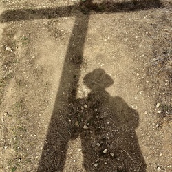
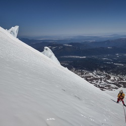
Solo day hiked Thurs 1/25/24 – Nice trail very similar to the Bear Canyon and Register Ridge trails on Baldy. Rained on the drive in but was just a heavy, humid feeling mist halfway up in weather warm enough to layer down early at Bonita Peak. Trail was in good shape after this week’s rain allowing for good traction on the dirt and scree. Thanks to the folks that have trimmed off the Yucca tips on the plants closest to the trail - most of the remaining sharp ones can be avoided. Took up a full 30L pack and never got snagged on anything when on the main trail. Snow on the last 200 feet up but easily passed with boots alone right now. Awesome panoramic views off the Iron summit which was above the clouds today, especially of Mount Baldy and Baden-Powell. Like others have said, the trail is easy to follow with a little extra spotting required at some of the rock areas. 5 hours up at a very comfortable pace and 3 hours back to the junction for Peak 3529. Bushwhacked my way up the southwest ridge of Peak 3529 which was not too bad to reach its overgrown summit. Decided to make a direct ascent down its north face which was a bad choice. Tried to bushwhack for an hour through the very dense overgrowth which brought me to a crawl (literally) so I traversed to a drainage/wash on the topo map that would make for a better trip down and then up to rejoin the Heaton Flats Trail. Recommend the southwest ridge route up and down this peak! Took too much extra time and effort for this peak after a nice day on the Heaton Flats Trail. Drank 3L of water of the 4 brought but would only bring 2-3 for Iron when we finally get real winter weather! Logged 14.9 miles/6721 vertical ft. with Gaia.
★
★
★
★
★
First time in this part of the San Gabriels out of Wrightwood. Nine mile Jeep ride to campground, then another 2.75 to Cabin Flat. Water still running out of the back side of Pine Mountain. Hard to notice the slight descent until we had to return, about 1150 feet. Several hunters tromping around. Great views on the way out. Stopped to drop a couple of weary hunters off at their vehicle. Jess stopped to get a sandwich in town. Nice day of exploring.
★
★
★
Solo hiked Fri 07/28/2023 – Early trip up Baldy Bowl trail to the summit in time to share the sunrise with a small herd of Bighorns. Down the north face (North Backbone) and up Dawson Peak. Continued on the ridge to go up Pine Mountain. Pleasant weather, thanks to a nice breeze all day. Back up Mt Baldy, across Mt. Harwood and down the Devil’s Backbone trail to Manker Flat. . Hard to believe we’re still stepping across snow on the north face this late in the year. Another great day for hiking this summer before the weather changes. Highly recommend the North Backbone Trail out to Dawson, Pine and Wright summits. Last water available to fill up is just past Ski Hut and dry after that. Surprised there were not more people out on the trail on a Friday. Like everyone else says – start early for maximum enjoyment, bring plenty of water (went through 4L) and use insect repellent and/or a mosquito net! Logged 15.5 miles/6716 vertical ft. with Gaia
★
★
★
★
★


Hardest hike I’ve ever done super difficult this mountain is a Beast amazing views at the top breathtaking jaw dropping happy yo conquered it
★
★
★
★
★

Great hike today, tough as hell on the last 3 miles. Lots of vm loose rocks and very steep. Spectacular views!
★
★
★
★
The beatings started around mile four. I brought 7L of water and finished all of it! Trail is well maintained and full of wild flowers. Lots of annoying bugs and saw a few baby rattlesnakes. Save your knees and bring some poles especially for the decent. I recommend gaiters, I had a lot of little rocks in my shoe from the decent. Also, I recorded over 16 miles and a 7,000 ft ascent. Enjoy the beatings!
★
★
★
★
★

Very beautiful and dramatic views on this hike. Definitely felt the elevation change and pretty challenging incline. Wind from the Santa Ana winds made this more difficult on the true backbone.
★
★
★
★
★

Trail washed out in spots. Lots of graffiti and inexperienced hikers. Very sad example of internet exposure ruining a really cool spot.
★
★
★

This was a fun and easy hike to Big Horn Mine. I would have given this trail 5 stars, but there was sooooo much trash. Our small group (my hiking family) took trash bags with us, and thankfully so! We picked up about 5 lbs of recycle trash (beer bottles, gatorade, water, and more beer cans), and about 10-15 lbs of trash trash. There were so many glow-sticks, tissue paper, candy wrappers, snack wrappers/bags, trashed clothing, and the worst of all - some person pooped IN THE MINE! It was rank! We doubled bagged that and put it in our large trash bag. I hope those that go on this trail will pack their trash out with them. You carried it full, now carry it out empty.
The views were breathtaking, the mine was awesome, there is bathrooms and trashcans at the trailhead. You go left for the mine and right for the eternal switchback trail to Mt. Baden-Powell.
I recommend this hike.
★
★
★
★

Recommended that you do this hike on a cool weather day. No water sources on this trail you have to carry all your water with you. It was 85° and i carried 6L and it was barely enough. Drank 1L the 1st 3 miles stashed 2L at the saddle for the way back kept 3L with me. The uphill is steep and the downhill feels steeper. Pants and boots reccomend you might be able to get away with trail runners. Definitely a Very Strenuous Advanced hike.
★
★
★
★
★


 stars
stars