Australia
›
Queensland
›
D'Aguilar National Park

Best Hiking Trails in D'Aguilar National Park

14 reviews


link Copy Link
  • facebookFacebook
  • Twitter iconTwitter
  • emailEmail
directions Driving Directions

Seasonal Popularity

Overview

D'Aguilar National Park is a protected area in Queensland.


  • Hiking Trails (12)
  • Reviews (14)
  1. 1
    Rocky Hole via Lovedays Road
    ★ ★ ★ DIFFICULT 13.9 mi
  2. 2
    England Creek bush camp Loop via England Creek Road and Joyners Ridge Road
    ★ ★ ★ ★ ★ DIFFICULT 14.5 mi
  3. 3
    Araucaria Loop via Somerset Trail
    ★ ★ ★ ★ ★ MODERATE 8.1 mi
  4. 4
    Camp Mountain Loop
    ★ ★ ★ ★ EASY 3.1 mi
  5. 5
    Jolly's Lookout via Thylogale Walking Track and Thylogale Track
    ★ ★ ★ ★ MODERATE 5.2 mi
  6. 6
    Piper Comanche Plane wreck (2 March 1977) via Lepidozamia Road
    ★ ★ EASY 3.7 mi
  7. 7
    Jolly's Lookout Loop via Thylogale Track
    ★ ★ ★ MODERATE 7.6 mi
  8. 8
    Maiala via Rainforest Circuit
    ★ ★ ★ EASY 1.7 mi
  9. 9
    Mount Nebo Lookout via Morelia entry and Morelia Walking Track
    ★ ★ EASY 3.4 mi
  10. 10
    North Kobble Bush Camp via Lepidozamia Road and Kobble North Break
    ★ ★ ★ MODERATE 5.4 mi
    user_profile stars
    rosscopk 9 months, 2 weeks ago
    Middle Kobble Creek waterfall Loop via Lepidozamia Road and Middle Kobble Break
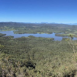
    Very enjoyable walk along fire breaks / old logging trails. Probably best walked clockwise - this way you go down the steep pinch south into Middle Kobble Ck Bush Camp. Other than this short section of about 1 click it is not a steep walk. Lepidozamia Park offers shelter / table / fire place and seating. Good views over Lake Samsonvale and Glasshouse Mtns depending where along the walk you are.
    ★ ★ ★ ★

    user_profile
    Twev 1 year, 2 months ago
    England Creek bush camp Loop via England Creek Road and Joyners Ridge Road
    Not a hard trail, length and big hill if you go clockwise makes it physically hard. Fire trail width all the way and in good condition
    ★ ★ ★ ★

    user_profile
    susie.gainford 1 year, 3 months ago
    Track (28/3/21, 12:56:06pm)
    Excellent creek crossings and steep pitch out.
    ★ ★ ★ ★ ★

    user_profile
    Carmine 1 year, 8 months ago
    The Guzzler Ultra 2020 100km
    The 100km run !!
    ★ ★ ★ ★ ★

    user_profile
    jared 1 year, 8 months ago
    The Gantry to Rocky Hole, Mount Mee, QLD, Australia
    Great 4WD track, not too hard, just right.
    ★ ★ ★ ★

    user_profile
    Mdb.carroll 2 years ago
    Piper Camanche trail @ D’Aguilar NP
    Overgrown bushy trail. Tropical rain forest. Saw a Roo hopping around and lots of nice birds. Steep section going down to plane wreck not recommended after significant rain fall. Sometimes the trail gets a bit thin but you can figure out the right way to go.
    ★ ★ ★ ★

    user_profile
    dbrdzr 2 years ago
    Piper Comanche Plane wreck (2 March 1977) via Lepidozamia Road
    Great hike!! We started a bit late (noon) but got back by 4:30. We hiked leisurely up then took a left turn down to the crash site. The trail down immediately became rocky n steep n not well marked. We found the plane but on the way back up the hill got off trail. So glad I had this app which got up back on trail!! The hike was forest n rain forest. We saw only 4 people. There was not much too much car noise from the surrounding roads (this was a Tues vs a weekend which may have been a factor). The first part of the trail isn’t hard n it is pretty well kept. Not so as u veer off n down to the plane so I wouldn’t rate this as an easy hike but give it a 4-5/10 for difficulty. I used trekking poles my partner did not...whatever u r most comfortable. Do bring water as well as the “10 essentials” n start prior to 10am.
    ★ ★ ★ ★

    user_profile
    gwdavo 5 months, 3 weeks ago
    D’Aguilar (12/1/22, 09:15:9)
    ★ ★ ★ ★ ★

    user_profile
    nomadsimpsons 9 months ago
    Piper Comanche Plane wreck (2 March 1977) via Lepidozamia Road
    ★ ★ ★

    user_profile
    ashwalford 9 months, 2 weeks ago
    Warner to Mount Byron
    ★ ★ ★ ★ ★

    user_profile
    Ben 1 year, 1 month ago
    Middle Kobble Road w/ Dad
    ★ ★ ★

    user_profile
    mr.jk1983 1 year, 2 months ago
    Track (18/4/21, 12:19:53pm)
    ★ ★ ★ ★

    user_profile
    Mpghonda 1 year, 9 months ago
    Piper Comanche Plane wreck (2 March 1977) via Lepidozamia Road
    ★ ★ ★

    user_profile
    susie.gainford 2 years, 2 months ago
    Track (26/4/20, 3:24:41pm)
    ★ ★ ★ ★ ★

  • Web App

    • Map
    • Find Trails
    • Upload
  • Resources

    • Hiking & Backpacking
    • Offroad
    • Hunting
    • Mountain Biking
    • Backcountry Skiing
    • Fishing
    • Map Catalog
    • Help & Forums
  • Purchase

    • Individuals
    • Professional
    • Outside+
    • Volunteer
    • Gifts
  • Company

    • Blog
    • Podcast
    • Jobs
    • Diversity
    • Partnerships
    • Media
  • Gaia GPS - Trail maps for every adventure

    Follow Us

    Download on the App Store Get it on Google Play

© Trailbehind Inc. - All Rights Reserved.

  Privacy • Terms

Outside Inc Logo

© 2022 Outside Interactive, Inc.

Outside Inc Logo