San Gorgonio Mountain Loop via South Fork Trail
20.4 mi
Distance
10 hrs 40 min
Time
terrain
4,551 ft
Elev Gain
Overview
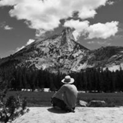
This is a difficult loop trail to San Gorgonio Mountain in San Gorgonio Wilderness.
This trail goes by Poopout Hill, Dollar Lake Saddle, Little Charlton Peak, Mine Shaft Saddle, Dry Lake, and South Fork trailhead parking lot.
Sights to See
Rate this Hike
★★★★★

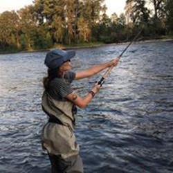
Solo day hiked 6/12/25 – the 3 saints over the last 3 weeks, San Jacinto-Antonio-Gorgonio in great weather. Zahniser-San Gorgonio-Jepson-Little Charlton-Charlton peaks on this loop. Went up really early on the Dry Lake Trail to just before Mineshaft Saddle before following Zahniser Peak’s NW ridge line to the summit for the sunrise which was well worth it. After signing the register, I headed down to the Sky High Trail for the scenic uphill trek around the north, east and south sides of San G. One of the highlights of taking Sky High are the great views of Dragon’s Head, Bighorn Peak and the Tarn. It’s been a while since I’ve climbed the northwest chutes of Dragon’s Head or stood in the middle of the Tarn (highly recommend) so I’ll have to put it on “the list.” After leaving the San Gorgonio summit, I took the SB Peak Trail northwest to the base of the Big Draw boulder stack (SE side of Jepson) before starting the cross country ridge run/climb for the other peaks. This part of the trek was the most fun, staying on or as close to the rocks on the north (Jepson Bowl) side of the ridge with great views the entire way. After reaching the Charlton summit and putting a new, bagged register in the beat up ammo box (on its side with no lid), I descended the talus field on the NW side to Dollar Saddle. Taking a WNW line down would have been on more stable ground but what fun would that have been? From here, I took the South Fork Trail back to South Fork Meadows and filtered a nice cold liter from the creek. Had my permit checked here by a friendly ranger before having a lengthy conversation about the San Gorgonio, the eastern Sierra and fly fishing. He did mention that there was a black bear with her two cubs at the far side of Horse Meadow which would have been nice to see as I’ve not seen a bear in San Gorgonio for years. Only a few fellow hikers on the last stretch before reaching a very empty parking lot. I brought a 3 L bladder and a 1 liter bottle for the loop which was ample, the liter from the creek being a luxury for mixing energy/electrolytes. You can carry less and filter from Dry Lake, Lodgepole Spring or Dollar Lake/Spring. I didn’t take the Dollar Lake Spur but a SGWA report from two weeks ago said the spring was flowing well. Much thanks to the trail crews for the deadfall removal and cutbacks on the South Fork and Dry Lake trails – best condition in years! Logged 20.8 mi /33.5 km & 5106 ft / 1556.3 m with Gaia
★
★
★
★
★


Public Tracks
South Fork Loop
From Hikin' Jim:
Two night plan: Start at the S. Fork Trailhead. Hike to Lodgepole Spring (reliable water year round except in multi-year droughts). Camp at nearby Lodgepole Camp. The next day, head to the summit and savor the view. After summiting, head to Dollar Lake Camp. There should be water in early season or in wet years coming from a spring at the south end of Dollar Lake. Both Dollar Lake and the spring frequently go dry. Check the conditions before embarking on your hike.
Water sources:
I'll start at the trailhead and go clockwise. In some times and seasons, there may be other water sources; I'm just trying to hit some of the more important ones here and just those on the route. See other sections for sources off the route.
1. Flume. **** This is the flume that diverts water from the S Fork of the Santa Ana River to Jenks Lake. Just after you pass the wilderness sign near Poopout Saddle, start looking to your left (east). You should see water flowing in the flume below you. The flume for whatever reason isn't shown on most maps but is a nice source of water after you've climbed up from the S Fork Trailhead.
2. Grinnell Crossing. ***** Extremely reliable water, perhaps the most reliable in the entire SGW.
3. Creek crossings in the S Fork meadows area. *****
4. Lodgepole Spring. **** There may also be water in Dry Lake. The water quality at the spring is typically better. There are also some small springs along the trail and at least one big spring below the trail as you come up from S Fork Meadows. The small springs aren't typically worthwhile (too shallow, too low flow). The one large spring is pretty worthwhile, but it's off trail and you've just passed a wonderful source down in S Fork Meadows and you'll soon get to another good source at Lodgepole, so I don't consider it vital.
5. Dollar Lake Spring. ** The spring is at the extreme south end of the lake, just above the lake. Both the lake and the spring frequently run dry in late season.
20230804_San Gorgonio Mtn Loop via South Fork TH (8/4/23, 3:38:33AM)
Solo hiked Fri 08/04/2023 – Same peaks-new route. Early start on the South Fork-Dry Lake trails to Dry Lake and Mineshaft Saddle. Up Zahniser Peak, out Sky High trail to the C-47 Memorial crash site and up to San Gorgonio summit. Descent to the Big Draw rock pile and then returning via the San Bernardino Peak – South Fork Trails. A few side excursions - south face direct ascent of Jepson, west face direct ascent of Charlton, out and back to Red Rock Flat from Dollar Lake Saddle. Another day of great summer weather in SG with a cooling breeze. Wanted to get some mileage on a loop I’ve never done and this was a good one. Dry Lake is still very picturesque these days and worth the hike in itself. Still one last snow patch on the Sky High route that others have mentioned, S-SW of summit (near the awesome view of Dragon’s Head). Depending on time of day, you can navigate it easily with bare boot step kicks or take the high and dry scramble around it. Self-arrest with a shortened trekking pole will not work here with a short and possibly deadly runout on to the rocks. Scrambling up Jepson linking use trail segments with the rocks was a blast, especially after climbing the ice and snow chutes from Jepson Bowl all winter. Tried to first ascend Charlton with from the east but the Chinquapin/Whitethorn thickets had no use trails through. Ended up going down the SB trail closer to Dollar Saddle and going up the west side which was a good rock scramble. Upper South Fork Trail is very scenic in the afternoon and a great way to come down. A few blowdowns left to hop but not too bad. Thanks again to the trail crews for all of the spring-summer tree removal/cutbacks. Having hopped 35 trees on a day hike in the dead of winter here, I have to say it’s nice. Logged 23.7 miles/5701 vertical ft. with Gaia

San Gorgonio Loop
Forgot to hit record from the peak heading towards Dollar Lake. I think I’m missing 2 miles or recorded trail.

San Gorgonio via Mine Shaft Saddle
San Gorgonio Wilderness Permit required
San Gorgonio via Mine Shaft Saddle
San Gorgonio Wilderness Permit required