meta

Devil’s Courthouse from Hwy 215 via the MST

based on 20 tracks & routes #23 hike out of 616 in
1.9 mi
Distance
55 min
Time
terrain
522 ft
Elev Gain

Overview

This is a nice hike to Devil’s Courthouse that adds a bit of distance and fewer crowds that starting from the main parking area.

From the MST trailhead on Hwy 215, it is a few miles with moderate climbing before you reach the spur out to Devil’s Courthouse. Look out on the way for a short side trail to the right that leads to some nice views over the Hwy 215/Middle Prong area.

Take a right on the spur to Devil’s Courthouse, stopping for a neat view above the BRP as you cross over a tunnel.

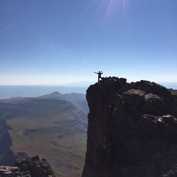
At the top of Devil’s Courthouse you will usually encounter tourist crowds, but the 360° views as far as Georgia make it worth it!

Return the way you came, or combine it with other trails for one of many possible loops.

Getting Started

There is a small parking area on Hwy 215 near the MST crossing. A short road walk may be needed, especially if you do as a loop with Flat Laurel Creek Trail

Taking Children

Great hike for kids, if they can manage the distance and elevation gain.


    Rate this Hike


Public Tracks

user_profile
CheapCigarMan 6 years, 2 months ago
Mountains to Sea Section 2
trail_hike_comments: **Waterrock Knob to Pisgah Inn** From Waterrock Knob to Flat Gap, the trail follows the Blue Ridge Parkway closely at most times. It gains some distance from the motor road on the southwest slope of the ridge line from there to Haywood Gap. From Haywood Gap to Beech Gap (NC 215), the trail enters the higher elevations of the Middle Prong Wilderness and encounters sections of beautiful spruce-fir forest. It passes the Green Mountain trail which and then a high waterfall on Mount Hardy, before entering some wildlife meadows. This segment of the Mountains to Sea Trail, combined with the Green Mountain trail to Green Knob, is [one of the best hikes in the region](http://www.hikewnc.info/besthikes/middle-prong-wilderness/green-knob). Portions of the trail in designated wilderness are unblazed, but generally easy to follow. From Beech Gap (NC 215), BRP mp 423.2, to Pisgah Inn at BRP mp 408.6: this portion of the trail travels through some of the higher mountains along the Pisgah Ridge. The trail ascends to Silvermine Bald through a moist mixed northern hardwood/spruce-fir forest, then levels out and passes through a forest of predominantly spruce until reaching Black Balsam Road. It skirts Black Balsam Knob and then the Graveyard Fields area via Graveyard Ridge, before descending significantly to cross the Yellowstone Prong at Skinny Dip Falls. It ascends again toward the Blue Ridge Parkway., trail_bike_comments: None
user_profile
bhamdans 8 years, 6 months ago
Mountains to Sea Section 02: Waterrock Knob to Pisgah Inn
Properties:, name: Mountains to Sea Section 02: Waterrock Knob to Pisgah Inn, segment: Mountains to Sea Trail - NC 215 to Devil's Courthouse Connector, mapid: 20, type: trail
user_profile
bhamdans 8 years, 6 months ago
Mountains to Sea Section 02: Waterrock Knob to Pisgah Inn
Properties:, name: Mountains to Sea Section 02: Waterrock Knob to Pisgah Inn, segment: Mountains to Sea Trail - NC 215 to Devil's Courthouse Connector, mapid: 20, type: trail
user_profile
Max Evans 7 years, 2 months ago