Wahkeena Spring Loop via Angels Rest Trail and Devils Rest Trail #420C
Overview
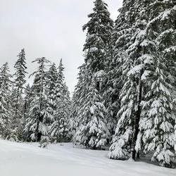
The lollipop loop from Angels Rest to Devils Rest in the western end of the Columbia River Gorge offers a diverse range of experiences. Angels Rest provides breathtaking views from its exposed promontory 1,500 feet above the Columbia River, while Devils Rest, located 900 feet above Angels Rest, lacks views from its mossy rock summit. Both Angels Rest and Devils Rest are part of the Boring Lava Field, a relatively young volcanic formation compared to the Columbia River Basalt flows. The trail passes through areas affected by the 1991 Multnomah Falls Fire and the more extensive 2017 Eagle Creek Fire.
The hike starts at the Bridal Veil intersection on the Historic Columbia River Highway, where there are two parking areas. The trails from each parking area converge above the lower parking area. The trail takes you through a forested slope with Douglas-firs bearing scorch marks from the 2017 fire. Along the way, you'll encounter vine maple, thimbleberry, sword fern, and patches of poison oak. From an open talus slope, you can enjoy views of the sheep paddocks below, the Columbia River, and various landmarks in the area. You'll also come across Coopey Falls and Upper Coopey Falls, which can be seen from short spurs off the trail.
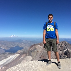
Continuing on, the trail leads to the Gorge face, offering more open views of Angels Rest, Larch Mountain, and Silver Star Mountain. The trail ascends through a scrubby landscape with snowberry, ocean spray, and fire-damaged snags. Eventually, you reach the crest of the Angels Rest promontory, where you can scramble among layered pillars of platy andesite and enjoy views of the Columbia River, downtown Portland, and the surrounding mountains.
After retracing your steps along the ridge crest, you'll continue on the Angels Rest Trail, passing the junction with Foxglove Way. The trail descends through various landscapes, including a recovering carpet of vegetation, an intact grove of old-growth trees, and a soggy Sitka alder bowl with seeps. You'll cross the Mist Creek Footbridge and pass the junction with the Primrose Path, eventually descending out of the fire zone. Along the way, you'll have views of Archer Mountain and Wahkeena Creek.
The trail then ascends through a slope of Douglas-firs and hemlocks, with views of Devils Rest. It passes through a grove that escaped the fire and offers a view north to Silver Star Mountain. After crossing footbridges and hiking through a devil's club thicket, you'll reach a clifftop promontory with extensive views of the Columbia River Gorge.
From there, the trail veers left and ascends steeply to the summit of Devils Rest, characterized by mossy boulders. Continuing the loop, you'll descend through an unburned stand of Douglas-fir and encounter the junction with the Red Shorts Cut. Following the new trail, you'll pass through a forest of hemlock and noble fir, remnants of past logging. The trail eventually meets Smith Road, follows it for a while, and then departs from it. After passing the Red Shorts sign and a road junction, you'll make a sharp right and descend under alders and Douglas-firs along the edge of the Eagle Creek Burn. The trail traverses through mature forest and dense thickets, finally arriving at the Angels Rest Trail-Foxglove Way Junction. From there, you'll make a left and return down the Angels Rest Trail to the parking area.
Overall, this loop offers a rewarding hiking experience with stunning vistas, waterfalls, spring views, and a variety of vegetation and terrain.
Getting Started
From Portland, drive east on I-84 to Exit 28 for Bridal Veil.
Go 0.4 miles after exiting the freeway, and make a sharp right turn on the Historic Highway at the Angels Rest Trailhead. If this parking area is full, drive a little farther west, and turn left into the second parking area for the Angels Rest Trail.
From the east:
From westbound I-84, take Ainsworth State Park Exit #35 and follow the Historic Columbia River Highway for 7.1 miles (11.4 km).
Sights to See
Rate this Hike
★★★★★


Public Tracks
 stars
stars