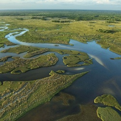
Walker Knob Overlook via Blue Ridge Parkway
1.3 mi
Distance
37 min
Time
terrain
434 ft
Elev Gain
Overview
This is a easy one way trail to Walker Knob Overlook in Blue Ridge Parkway.
This trail goes by Walker Knob.
Sights to See
Rate this Hike
★★★★★
Public Tracks
Mountains to Sea Section 3
trail_hike_comments: **Pisgah Inn to Black Mountain Campground**
Pisgah Inn, BRP mp 408.6 to Folk Art Center, BRP mp 382: from the Pisgah Inn to the Mount Pisgah Parking Area, the trail is co-signed as the Buck Spring trail. This leads past the old Buck Spring Lodge built by George Vanderbilt, where there are interpretive signs. From the parking area, the trail joins with the Mount Pisgah trail which leads to the top of Mount Pisgah itself. Continuing toward Asheville, the trail is co-signed as the Shut-in Trail and follows parts of Vanderbilt's original route to the Lodge from his Estate. Follows the Parkway closely along this section and meets up with it several times. Good day-hikes can be made from these sections of trail. Joins with trails leading to the Mills River and Bent Creek areas of Pisgah National Forest.
The trail then crosses the French Broad River, Interstate 26, US highways 25, 74-A, and 74 on bridges with the Blue Ridge Parkway as it skirts the Asheville area on a relatively low elevation and low relief stretch. At the Folk Art Center, the trail begins climbing again toward Mount Mitchell.
From the Folk Art Center, BRP mp 382 to Balsam Gap at BRP mp 359.8. Follows the Blue Ridge Parkway closely most of this segment. Travels from the low-elevation area near Asheville on a mostly gentle climb to Bull Gap near Ox Creek Road. Follows a historic carriage trail through many switchbacks to [Rattlesnake Lodge, one of the best hikes in the region](http://hikewnc.info/trailheads/mst/guidedhikes/rattlesnake.html). Ascends more steeply to Lane Pinnacle, where there are great views, then undulates over to the picnic area at Craggy Gardens, a high elevation area. A popular, heavily traveled section of trail goes from the picnic area to near the Craggy Visitor Center. Passes through the gardens and a historic trail shelter on this stretch and is also known as the Craggy Gardens trail.
The MST splits left, downhill, and goes to the junction w/ Douglas Falls trail. The trail then Climbs back to the Parkway and follows it closely, up and down, to Balsam Gap. There are some spectacular views on this part of the ridge, of the Black and Craggy Mountains, the Asheville watershed, and northern Buncombe County.
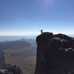
From Balsam Gap, BRP mp 359.8 to the Black Mountain Recreation Area by the South Toe River: climbs Blackstock Knob in a spruce-fir forest above Asheville Watershed. Follows knife-like ridge, then descends on an amazingly well-built section of trail to fields below Potato Knob. Fantastic veiws of Asheville reservoir. Descends to Mount Mitchell Road, NC 128. The segment from NC 128 up to [Potato Knob Fields](http://hikewnc.info/trailheads/mst/guidedhikes/potatoknob.html) is one of the best hikes in the region.
Past NC 128, the trail climbs gently, co-signed with the Buncombe Horse Range trail (on an old railroad bed) thru high-elevation hardwood forest to point near Camp Alice at Mount Mitchell State Park. Here it turns left; ascends very steeply on a segment co-signed with the Camp Alice trail to [Mount Mitchell's summit](http://www.hikewnc.info/gallery/mount-mitchell-state-park-hiking/), the highest point east of the Mississippi River at 6,684'. The trail then descends 3600' in 5.5 miles to the Black Mountain Campground via the Mount Mitchell trail where there are old-growth spruce forests. This last segment, from the summit to the campground, is the [Mount Mitchell hike](http://hikewnc.info/trailheads/mitchell/guidedhikes/mountmitchell.html) on this site., trail_bike_comments: None