meta

Blue Ridge Parkway to Cane River Gap via Big Butt Trail

based on 26 tracks & routes #1 hike out of 3 in
5.8 mi
Distance
2 hrs 49 min
Time
terrain
1,492 ft
Elev Gain

Overview

This track is a moderate one way hike off of the Blue Ridge Parkway. Done in the opposite direction, or as a round trip, it is a difficult hike due to the elevation gain

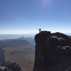
This trail goes by Little Butt, which has an overlook with sweeping views of the Black Mountain Crest. It also passes Big Butt, which can be reached with a short side trail. From there it travels along the ridgeline and past Flat Spring Knob, before beginning a long, steep descent to Cane River Gap.

The trail is well maintained with many nicely-built steps. There are no overly rugged sections, though there are some steep climbs.

Getting Started

The hike begins from Walker Knob Overlook on the Blue Ridge Parkway. The Mountains to Sea Trail (MST) also crosses here, so take care to take the correct trail.

The opposite trailhead is at Cane River Gap, which is accessed via remote roads. Note that it is a lengthy shuttle if you plan to leave a car at the terminus.

Taking Children

This is a fine hike for children. Consider a shorter round trip hike, only as far as Little Butt Overlook.


    Rate this Hike

    user_profile stars
    2 years, 7 months ago
    Terrific hike, and the trail was in great shape. We did this as an out-and-back from the BRP, and the climb back up from Cane River Gap is a challenge!
    ★ ★ ★ ★


Public Tracks

user_profile
CheapCigarMan 6 years, 2 months ago
Big Butt
trail_hike_comments: Yes, this really is the trail's name. Starts at the left side (facing away from the road) of the Walker Knob Overlook in Balsam Gap on the Blue Ridge Parkway, heading downhill. (The trail to the right, heading uphill, is the Mountains to Sea Trail). The trail has been well-maintained in recent years and is in fantastic shape, with lots of water management and well-placed log steps minimizing erosion as the trail has seen increased usage. It used to become quite overgrown in the summer, but overgrowth had been actively trimmed as of my last visit in July 2017. The trail descends beside the Parkway, then angles north and continues onto Pisgah National Forest/Appalachian Ranger District property. It begins a gradual climb up Brush Fence Ridge, which is the western ridge of the Black Mountains. The trail passes through a high-elevation forest with lots of Red Spruce and Sweet Birch, a few Fraser Fir, and other northern hardwoods. Some of the Red Spruce along the ridge are enormous. The trail crosses a low-prominence unnamed summit and then climbs gently to Point Misery at 5715 ft. Past Point Misery, the trail descends somewhat more steeply through a set of switchbacks and more big Red Spruce. It bottoms out in a gap at about 5330 ft. and begins climbing again toward Little Butt mountain in an area with hawthorn trees. From Little Butt the trail follows the narrow ridge leading to Big which drops off steeply on both sides, where there are at times excellent views of the Cane River Valley, the eastern Black Mountains and Mount Mitchell - an exhilarating vista. The trail then skirts the east side of Big Butt before crossing Flat Spring Knob and a few smaller, unnamed summits on the ridge to its north. Where Wilson Ridge angles northeast, the trail angles northwest toward Cane River Gap, descending steeply through switchbacks. The northern terminus of this trail is on NC 197., trail_bike_comments: None