meta

Ramsey Cascades

based on 212 tracks & routes #1 hike out of 614 in
7.9 mi
Distance
3 hrs 50 min
Time
terrain
2,256 ft
Elev Gain

Overview

This is a difficult out and back trail to Ramsey Cascades in Great Smoky Mountains National Park.

Getting Started

The Ramsey Cascade trail is one of the most popular and rewarding hikes in the Great Smoky Mountains National Park. The 4-mile trail follows along the beautiful Ramsey Prong through a mature old-growth forest and ends at the 100-foot-high Ramsey Cascades, the tallest waterfall in the park. It is a difficult hike gaining 2,200 ft in elevation. The trail ends at the cascades and does not connect to any other areas, therefore it is one of the few dead-end trails in the park.

The trailhead is located at the parking area at the end of the gravel Ramsey Prong Road, 4.7 miles from the Greenbrier entrance to the park off U.S. 321.

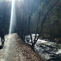
The trail begins with a gradual climb up an old road immediately after crossing the Middle Prong of the Little Pigeon River on a foot bridge. The Middle Prong, known locally as just “Greenbrier”, is a steep gradient, freestone stream. It is the largest stream in the park that holds the native Brook Trout. There are also Rainbow Trout in this lower section. If you fish upstream from here, be prepared to be in the river for quite some time as it will be far below the trail. This is a good area to spot black bears too, so keep any eye out for them.

At 1.5 miles, the road ends at an old turnaround at the confluence of Ramsey Prong with Middle Prong. This is also the old trailhead for the Greenbrier Pinnacle and the Cat Stairs which is no longer maintained by the Park Service. The trail narrows down here and turns up the north bank of Ramsey Prong which drains off Mount Guyot (6621 ft) the 2nd highest mountain in the Smokies. Fly fishermen can get in Ramsey Prong here and catch Brook Trout, but they will be committed for a very step and rough half-mile of wading until the next bridge crossing. If you go down to the creek be especially careful to watch for copperheads!

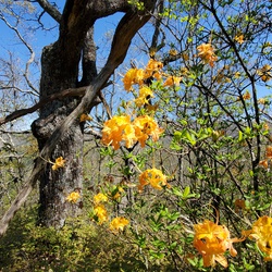
The trail crosses Ramsey Prong on a relatively high foot log at 2.2 miles. From here the trail will get considerably steeper and will enter the largest old-growth forest in the park. This area escaped much of the logging, and therefore has some very large trees of record size. A little further up the trail is a grove of extremely large tulip poplars. The trail crosses the stream several more times and becomes much more steep and rocky. After a strenuous climb over the last 0.5 mile, the trail ends at the base of Ramsey Cascades.


Sights to See


    Rate this Hike

    user_profile
    1 year, 6 months ago
    I have hiked all the trails at the Smokies and while this would be a moderate trail for a frequent Hiker, it should be rated difficult for the casual visitor. I have seen people carrying purses, in slick tennis shoes, and in heavy coats inappropriate for the weather. These unprepared people generally turn back after the 1st mile. There is reasonably steep elevation gain over slick rocks in several places. Trail is currently closed due to flooding in the area summer 2022.
    ★ ★ ★ ★ ★

    user_profile
    1 year, 10 months ago
    The first mile is pretty easy, but it gets steep after that. There's a bit of rock scrambling but nothing too difficult, and the view at the falls is worth it.
    ★ ★ ★ ★ ★

    user_profile
    2 years ago
    Great hike, lots of climbing over rocks and boulders. Great view once your at the falls. Not sure i'd agree with a moderate difficulty, and if this is a true moderate difficulty hike, I'd hate to see a difficult one.
    ★ ★ ★ ★ ★

    user_profile
    4 years, 2 months ago
    Loved the hike but those steps were a killer. Straight up all the way but so worth it
    ★ ★ ★ ★ ★

    user_profile
    5 years, 3 months ago
    Very good walk. A little difficult at times but well worth it.
    ★ ★ ★ ★

    user_profile
    1 year, 10 months ago
    ★ ★ ★ ★ ★

    user_profile
    2 years, 4 months ago
    ★ ★ ★ ★ ★

    user_profile
    2 years, 11 months ago
    ★ ★ ★ ★

    user_profile
    3 years, 3 months ago
    ★ ★ ★ ★ ★

    user_profile
    3 years, 9 months ago
    ★ ★ ★ ★ ★

    user_profile
    4 years, 1 month ago
    ★ ★ ★ ★ ★

    user_profile
    4 years, 4 months ago
    ★ ★ ★ ★ ★

    user_profile
    4 years, 8 months ago

    user_profile
    4 years, 8 months ago

    user_profile
    4 years, 8 months ago

    user_profile
    5 years ago
    ★ ★ ★ ★


Public Tracks

user_profile
jkjjkkc 4 years, 2 months ago
user_profile
Caroline 2 weeks, 1 day ago
user_profile
andywarmack 3 years, 3 months ago
user_profile
turnerc2 3 years, 4 months ago
user_profile
matt_a37032 3 years, 5 months ago
user_profile
annakoby 3 years, 6 months ago
user_profile
gwevans36 3 years, 6 months ago
user_profile
tommchugh99 3 years, 8 months ago
user_profile
mattpadberg 3 years, 10 months ago
user_profile
bhm7272 4 years, 7 months ago
user_profile
dalecumbie69 4 years, 7 months ago
user_profile
Christine 4 years, 8 months ago
user_profile
caroline.iantosca 4 years, 8 months ago
user_profile
jsd37 4 years, 8 months ago
user_profile
jpac 4 years, 9 months ago
user_profile
Masey 4 years, 9 months ago
user_profile
Masey 4 years, 9 months ago
user_profile
Brandon 4 years, 9 months ago
user_profile
sachiarya 4 years, 9 months ago
user_profile
Susan Porter 4 years, 11 months ago
user_profile
rliuzza 4 years, 11 months ago
user_profile
Vince 5 years, 6 months ago
user_profile
shamrockdab 6 years ago
user_profile
David Prichard 6 years, 2 months ago
user_profile
steve 7 years, 5 months ago
user_profile
waterfallshiker 8 years, 1 month ago