Charlies Bunion via Appalachian Trail
Overview
This is a moderate one way trail in Great Smoky Mountains National Park.
This trail goes by Newfound Gap Overlook, Mount Ambler, Icewater Spring Shelter, Masa Knob, Charlies Bunion, Dry Sluice Gap, The Sawteeth, Porters Gap, False Gap, Laurel Top, and Pecks Corner.
Getting Started
The hike to Charlies Bunion (5,564 ft) begins at the Newfound Gap overlook on the Tennessee - North Carolina border (5,049 ft). To reach the trailhead, take the Newfound Gap Road 13 miles up the mountain from the Sugarlands Visitor Center. From Cherokee, North Carolina, the gap is 20.2 miles from the Oconaluftee Visitor Center.
The trail to Charlies Bunion is along the famed Appalachian Trail (AT). It leaves from the Newfound Gap parking lot, right next to the stone Rockefeller Memorial and heads east. This is where President Franklin Delano Roosevelt formally dedicated the Great Smoky Mountains National Park on September 2, 1940, “for the permanent enjoyment of the people.”
The AT begins with a long steady climb to the east. You will definitely want your camera on this trip, and a little more than a half-mile up the trail you be rewarded with beautiful views of the North Carolina side of the Smokies to the south. On the left, Mount LeConte will soon dominate your view. The highest peak on LeConte is the middle one, High Top (6,593 ft). You are, literally, walking along the crest of the Smokies.
At 1.6 miles the Sweat Heifer trail takes off to the right and goes down Kephart Prong to the Newfound Gap Road. The AT will continually climb, and at 2.7 miles reaches the top of Mt. Kephart (6,034 ft). At this point, the Boulevard trail takes off to the left and goes to Mount LeConte.
Make a note that about 400 ft down the Boulevard is a side trail that leads 0.5 miles to the Jumpoff, a rocky outcrop on the side of Mt. Kephart with even more panoramic views. The trail to the Jumpoff is not an official trail but it is marked leading off to the right. It basically follows a rocky drainage ditch to the top and then back down the other side to the Jumpoff. From here you can see your final destination, Charlies Bunion, to the east. The Bunion is not as easy to recognize as you might think. In the winter if you look back up on the spine of the ridge you can see the sign where the Charlies Bunion side trail leaves the AT.
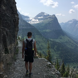
Continuing on the AT you will soon arrive at the Icewater Spring shelter. The spring is on the other side, flowing from a pipe onto the AT. At 4.0 miles from the trailhead you will arrive at the side trail to Charlies Bunion and arguably the best view in the Smokies. On a clear day, you can see a long way to the north – northwest across the Tennessee Valley. Back to the west, from where you came, you can see Mt. Kephart and the Jumpoff and a little more to the right is Mount LeConte and Myrtle Point. Looking far out to the northeast is Mt. Guyot (6,621 ft) the 2nd highest mountain in the Smokies.
Charlies Bunion is a large rock outcropping. The area is a bit tight and you definitely want to watch your footing here – and keep an eye on the kids! The view is great on a clear day, but when there are clouds below and the mountain tops rise above the “smoke” that makes them famous, it is hauntingly beautiful.
Believe it or not, but ½ mile to the east there was an old unmaintained trail that used to come up the steep valley from Porters Creek in the Greenbrier section far below. For years, it was considered to be the most dangerous trail in the park for good reason!
Taking Children
The sign for the side trail to Charlies Bunion from the AT says "Closely Control Children". That advice should be heeded!
Sights to See
Rate this Hike
★★★★★