Harrison Camp via Heliotrope Ridge Trail
5.0 mi
Distance
2 hrs 13 min
Time
terrain
1,385 ft
Elev Gain
Overview
This is a moderate out and back trail to Harrison Camp in Mount Baker-Snoqualmie National Forest.
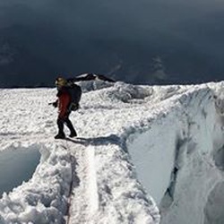
This trail goes by Coleman Glacier and Coleman Glacier Lookout.
Rate this Hike
★★★★★


Public Tracks

Rob: Heliotrope Ridge Trail
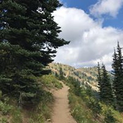
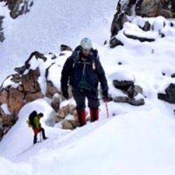
Another interesting road and drive, with a surprising amount of cars at the trailhead. Room for about 25 cars, and good bathrooms.This looked like a rather short hike but don't be misled, it's work. The trail is well maintained and graded nicely for the upward climb. You travel through several different terrains - forest, rock fields, and green fields. The best part for us were the 4+ large streams/waterfalls, There are no bridges to cross these, so you have to scramble. Be aware... as this is glacier fed, the water is extremely cold. Deb took her boots off for one of the crossings, and let's just say it was "invigorating".The last stream/waterfall to cross is very difficult as it splits apart to two streams and it's fast moving. A warning here: the streams will look MUCH different on the return trip. As the day progresses, more of the snow-pack & glacier melts, and the streams get much deeper and faster. We had more difficulty on the return trip at the split stream. We couldn't find where we had crossed, as the water was deeper and the rocks where now covered.Near the end, there are several different boot paths leading in different directions. We tried to stay on a larger trail as to not step on the vegetation. Wind your way up to the ridge, and BAM - Coleman Glacier is surreal. Pictures just don't do it justice. We climbed farther up the mountain next to the glacier and picked a nice spot in the sun for lunch. We could hear the glacier calving and water running just below it's surface. This was a great trail to run down. Pit toilet at around the half way point.

Heliotrope Ridge Trail
Another interesting road and drive, with a surprising amount of cars at the trailhead. Room for about 25 cars, and good bathrooms.This looked like a rather short hike but don't be misled, it's work. The trail is well maintained and graded nicely for the upward climb. You travel through several different terrains - forest, rock fields, and green fields. The best part for us were the 4+ large streams/waterfalls, There are no bridges to cross these, so you have to scramble. Be aware... as this is glacier fed, the water is extremely cold. Deb took her boots off for one of the crossings, and let's just say it was "invigorating".The last stream/waterfall to cross is very difficult as it splits apart to two streams and it's fast moving. A warning here: the streams will look MUCH different on the return trip. As the day progresses, more of the snow-pack & glacier melts, and the streams get much deeper and faster. We had more difficulty on the return trip at the split stream. We couldn't find where we had crossed, as the water was deeper and the rocks where now covered.Near the end, there are several different boot paths leading in different directions. We tried to stay on a larger trail as to not step on the vegetation. Wind your way up to the ridge, and BAM - Coleman Glacier is surreal. Pictures just don't do it justice. We climbed farther up the mountain next to the glacier and picked a nice spot in the sun for lunch. We could hear the glacier calving and water running just below it's surface. This was a great trail to run down. Pit toilet at around the half way point.

Descent from Glacier Creek
Very pretty hike. Lots of little stream crossings, Glacier Creek was too much to cross. Several pretty waterfalls on trail.

Mount Baker Wilderness Ride
https://connect.garmin.com/modern/activity/19586961232

monday 6/30 Heliotrope trail to Cole.anglacoet overlook.
Heliotrope trail.to Coleman glacier overlook,