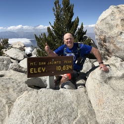
meta

San Jacinto Peak via Skyline Trail

based on 90 tracks & routes #12 hike out of 79 in
15.2 mi
Distance
6 hrs 18 min
Time
terrain
10,276 ft
Elev Gain

Overview

This is a difficult one way trail in Mount San Jacinto State Wilderness.

This trail goes by Notch 1, Grubb's Point, Grubbs Notch, Park Ranger, Upper Chinquapin, Ranger Station, Wellman Divide, and San Jacinto Peak.


    Rate this Hike

    user_profile
    2 years, 5 months ago
    Great weather, lost the trail a few times and stopped once or twice for a few quick rock bouldering sessions. Magnificent views.
    ★ ★ ★ ★ ★

    user_profile
    6 months, 2 weeks ago
    ★ ★ ★

    user_profile
    1 year, 2 months ago
    ★ ★ ★ ★ ★

    user_profile
    2 years, 4 months ago
    ★ ★ ★ ★

    user_profile
    2 years, 8 months ago

    user_profile
    2 years, 11 months ago
    ★ ★

    user_profile
    3 years ago
    ★ ★

    user_profile
    3 years, 9 months ago
    ★ ★ ★ ★ ★

    user_profile
    4 years, 5 months ago
    ★ ★ ★ ★ ★


Public Tracks

user_profile
Vish Kot 4 years, 11 months ago
C2C 12/23/17 4:19:47 AM
Hiked with John Kang and Irene
user_profile
Erika Lawson 5 months, 1 week ago
Cactus to Clouds
With Kali. Epic!!!
user_profile
dombroskyeric 1 year, 5 months ago
user_profile
milbeye 2 years ago
user_profile
JohnP 4 years, 5 months ago
user_profile
athuppul 4 years, 6 months ago
user_profile
dlcisw 5 years, 11 months ago
user_profile
dlcisw 5 years, 11 months ago
user_profile
Angelaing 6 years, 6 months ago
user_profile
briley 7 years, 5 months ago
user_profile
Lief 7 years, 7 months ago
user_profile
Lief 7 years, 7 months ago