meta

Mount Defiance Loop

based on 302 tracks & routes #18 hike out of 65 in
11.3 mi
Distance
4 hrs 27 min
Time
terrain
4,852 ft
Elev Gain

Overview

This is a moderate loop trail to Mount Defiance in Lindsey Creek State Park. One of the toughest hikes in the gorge (5,000ft elevation in approx. 5 miles), and an excellent training hike for entry level mountaineering climbs. This is a great skill check before jumping onto a South Sister/ Mt. St. Helens/Mt Adams level climb.

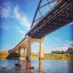
This trail goes by Warren Lake, Lancaster Falls, Lower Lancaster Falls, Hole-in-the-Wall Falls, and Cabin Creek Falls.

Driving Directions
From Portland, drive east on I-84 for more than 50 miles to Exit 55, signed for the Starvation Creek Trailhead and Historic Columbia River Highway State Trail.

There's no westbound exit to the Starvation Creek Rest Area, so drivers from the east (Hood River) will need to continue to Herman Creek Road and double back. Similarly, when leaving the rest area westbound drivers (Portland) will need to drive east on I-84 for about a mile and take the Viento exit, which leads to an underpass and then an I-84 on-ramp to Portland.

Be aware that the two primary hiking trails at this location (Starvation Ridge and Mt. Defiance) do not begin within the state park area by the restrooms and Starvation Creek Falls (walking east leads to Viento State Park along the historic highway), but instead require walking west, back alongside the freeway on the paved Historic Columbia River Highway State Trail. This route offers close approaches to Cabin Creek Falls and Hole in the Wall Falls. The Starvation Ridge Cutoff Trail also descends to this lower walk-in section.

Getting Started

Start at Starvation Creek State Park. There are toilets and the parking is ample and overflow on the wide shoulders. Expect lots of cars in the summer, so arrive early.

Head west along the old HWY30 until you see sign for Mt. Defiance and make a left. Start with Starvation Ridge or Defiance, they will both lead you back to the same spot. The climb goes uphill, continuously and quickly. Carry a good map or GPS if you climb early spring as the snow can disguise the trail at the top and it's easy to miss the path.

Taking Children

Would only recommend this hike for experienced children as the hike is long and steep.


Sights to See


    Rate this Hike

    user_profile
    4 years, 9 months ago
    Super challenging hike. Great if you want a challenge and to cross Mt Defiance off the bucket list. We did is as a training hike for a longer backpacking trip. There are better view hikes around and the TV antenna campus at the top is not the tranquil, wilderness experience I was looking for. Trail surface is very loose and coming down was precarious. But super satisfying to have done. Note: the very bottom of the Starvation creek trail was closed due to a slide, so you can either do an out and back on Mt defiance trail, or we cut across to rejoin trail above slide.
    ★ ★ ★ ★

    user_profile stars
    4 years, 11 months ago
    Hiked 5/6/19 13.6 miles with 5249 elevation gain. Did a loop hike starting with Defiance trail, to Mt. Defiance summit, to Warren Lake, to Mitchel Point, to Starvation Ridge trail and back on Mt. Defiance. Took us over 14hrs to complete. I was the first car in the lot at Starvation Creek State Park at 4:15am. Mt. Defiance was a great steep switchback trail with some flat sections in the forrest up high. Lots of downed trees on the trail. There is snow right after the scree field trail junction which we opted out of and crossed the snow instead (we used our microspikes in the snow). 2 to 4ft of snow in places. 2 miles or more of snow. Views were amazing the day we went. Couple good camp spots at Warren Lake. Mitchell point had OK views. Starvation Trail was super hard with very few switchbacks, so you're almost always going straight down. Poison oak on the trail, so make sure you cover up your skin. Lots of beautiful flowers and amazing view points. Visited 12/8/18. Beautiful area to stop at for hiking, sightseeing and a great lunch spot with a couple picnic tables next to Viento falls. Paved trails look very new. Bathrooms were flushing toilets and very clean inside, but only have air dryers, no paper towels for drying your hands. I've seen this place a bunch of other times while visiting the gorge and have always wanted to stop by and check it out. I came here to hike mt defiance trail. The trailheads are easy to find. Mt defiance, starvation ridge and a couple others are on the 14 going west when you walk on the paved path. Starvation ridge from historic trail paved path is closed but you can reach it on mt defiance trail. I did not complete trails because there were creek crossings on both mt defiance and starvation ridge that had no bridges, I was wearing my summer hiking boots (not wanting to get them wet in the water), it was cold out and I was hiking alone. This area is a must stop if you have the time to check it out. I will definitely be back to hike again. Counted 4 waterfalls.
    ★ ★ ★ ★ ★

    user_profile
    1 year, 7 months ago

    user_profile stars
    1 year, 10 months ago
    ★ ★ ★ ★ ★

    user_profile
    3 years, 5 months ago
    ★ ★

    user_profile
    3 years, 9 months ago
    ★ ★

    user_profile
    4 years, 9 months ago
    ★ ★ ★ ★ ★

    user_profile
    4 years, 10 months ago
    ★ ★ ★ ★ ★


Public Tracks

user_profile stars
Simon 5 years, 6 months ago
Mt Defiance
Butt kicker for sure. Lots of elevation gain. Great views able to see Hood, Rainer, Adams and St Helens.
user_profile
Ralph Daub 5 years, 11 months ago
2018-05-20 - Starvation Creek to Mount Defiance
With Lynne Petersen, John, Mercedes, Shannon
user_profile
mikesworkbench 9 years, 1 month ago
Starvation Creek Ridge Trail Short Loop
Length: 3.359 km (2.087 mi)
user_profile
alcreuziger84 4 years, 10 months ago
user_profile
felice.kelly 4 years, 11 months ago
user_profile
sz4x21 4 years, 5 months ago
user_profile
rtobrien3 4 years, 7 months ago
user_profile
oscarnbarbara 4 years, 9 months ago
user_profile
cgsandison 4 years, 9 months ago
user_profile
Guerilla Tictacs 4 years, 9 months ago
user_profile
dyerhealy 4 years, 9 months ago
user_profile
eisnerb95 4 years, 10 months ago
user_profile
nick.chope 4 years, 10 months ago
user_profile
Azure 4 years, 11 months ago
user_profile
Zuehlsdorf 4 years, 11 months ago
user_profile
thereinhardts 5 years, 9 months ago
user_profile
thereinhardts 5 years, 9 months ago
user_profile
thereinhardts 5 years, 9 months ago
user_profile
Zuehlsdorf 5 years, 10 months ago
user_profile
Terry Petersen 5 years, 11 months ago
user_profile
Michael 5 years, 11 months ago
user_profile
Andrew Weygandt 6 years, 10 months ago
user_profile
Jon Ellinger 7 years, 2 months ago
user_profile
karlin dye 7 years, 9 months ago
user_profile
runnerteri 8 years, 3 months ago
user_profile
Madi.g 8 years, 8 months ago
user_profile
Michael 9 years, 11 months ago
user_profile
7.jwmcc 10 years, 10 months ago