Deer Springs Trail
5.2 mi
Distance
2 hrs 30 min
Time
terrain
1,606 ft
Elev Gain
Overview
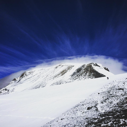
This is a moderate one way trail in Mount San Jacinto State Park.
This trail goes by Wellman Divide and Little Round Valley.
Rate this Hike
★★★★★

Solo hiked Thurs 08/10/2023 – Deer Springs / PCT trails to San Jacinto Peak, down to San Jacinto Azimuth Benchmark rock pile, Peak Trail to Miller Peak, down to Wellman Divide, out Round Valley Trail to High Trail, direct ascents of Landells/Luella Todd and Divide Peaks. Some passing dark clouds with full sun in the afternoon - very nice, cool weather for hiking. One docile Southern Pacific snake trailside in the early morning just above Strawberry JCT – surprised there weren’t more out during the day. First strong water on Deer Springs for filtering at the 6.5 mile mark (North Fork San Jacinto River). First time locating the actual SJ Azimuth survey marker high up in the rocks. First ascents of Landells and Divide peaks out of Round Valley were a lot of fun with Class2/3 summit blocks- many different ways up with great holds. Water pipe at Round Valley Ranger Station, Wellman’s Cienega, and Strawberry Cienega all flowing well. Not too many people out with the tram closed. A few Western Gray squirrels approaching the size of my youngest cat. Long day but great time to hike SJ in great weather with a still vibrant backdrop. Seems like the bird population has notably increased this year but then so has the bug population (only a problem on the last 2 miles down to the Deer Springs trailhead. Logged 26.1 miles/6688 vertical ft. with Gaia ___________________________________________________________________________________________________________________________ Hiked Friday 05/05/2023 solo – Deer Springs to Suicide Rock to Strawberry Junction to PCT (Strawberry Cienega Direction). Was going to do a quick out and back to Suicide Rock but the snow and weather were too optimal not to add Strawberry Junction and part of the PCT to Strawberry Cienega. First hike this year without mountain boots/auto crampons, using lower mid boots instead. You could easily wear trail runners for Suicide Rock and possibly for a trip to Strawberry Junction in another week. Not the case for PCT- high top boots/crampons still required. Amazing to see the drastic increase in snow melt and volume of water coming down the mountain. Nice to hear the roar of the water even if it means more mud. Not many obstacles to get around on this trail including downed trees and water crossings, especially compared to the middle route/Devil’s Slide. Met a lot of friendly people starting up on my way out as now is a great time to consider hiking the lower part of this scenic trail with the bulk of the snow gone. Logged 10.4 miles/3161 vertical ft. on Gaia
...........................................................................................................................................................................................................................................Hiked Friday 03/24/2023 – Deer Springs Trail to Strawberry Junction/Camp on PCT. In spite of an early start to get firmer snow, I post holed 6-8 inches on long tail snowshoes for the entire trip. It was a great workout but brutal on the way up with this week’s loose powder on top of last week’s thin crust. Even with snowshoes, I was frequently in snow up to my knees with a full pack. That said, it was still a nice trek through the SJ Wilderness with nice views of the sun hitting the Tahquitz peaks and Diamond Valley Lake. I tried a few climbs off the Marion Creek gully but crampons were unusable in the soft layers. There were frequent water crossings on this route but easier to traverse than on Devil’s Slide. This was the second time this month that a mountain lion has put tracks through mine between going out and coming back. If you can wait for the snow to consolidate for a week before going up, you’ll find it more enjoyable as I went too early and you might also have a tracked trail to follow (recommend offline nav + paper maps as the snow frequently sluffs/buries the trail). I had planned to go up Devil’s Slide from Humber Park but the last part of Fern Valley Road near the trailhead was not yet plowed and my attempt to cross it was unsuccessful. Logged 10.1 miles/2844 vertical ft. on Gaia.
★
★
★
★
★