Monroe Trail
3.1 mi
Distance
1 hrs 10 min
Time
terrain
2,531 ft
Elev Gain
Overview
This is a moderate one way trail in Vermont.
Sights to See
Rate this Hike
★★★★★


Public Tracks

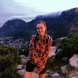
Camels Hump
climbed camels hump (4081') alone on the last day of the Vermont trip
went up in late afternoon, mixture of trail running and speed walking

Camel's Hump Rd (East)
Carrying 30.8 lbs, drank all my camelback. I had a third liter in a canteen. Tony drank most of his water too. Tony carried 30.2lbs.

Waterbury Hike
https://connect.garmin.com/modern/activity/23285554143

Camels Hump Monroe Trail Monday Morning Hiking
While visiting Aunt Lynn & Uncle Jack