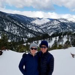
Rigorous 4,800 ft ascent/descent. Busy place since the AT runs through it. I did a loop. Ascent seems much harder on AT vs. trail 303 that I took up the mountain, but 303 ascent was rigorous too. I returned down the mountain on the AT. Weather was perfect. Apple Watch said the total ascent was 4,799 with total hiking miles of 16.57
★
★
★
★

Not for the casual hill walker. This is an amazing day hike with amazing scenery and a grueling climb.
★
★
★
★
★

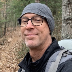
Beautiful unseasonably warm November day. Well traveled, easy to follow trail, with enough boulders and smaller rocks to make it interesting. Trees were mostly bare, but the bountiful freshly fallen leaves painted the entire landscape orange, yellow, and gold. Saw a few folks early on the hike but just me and the breeze for the last six miles. Great workout and mental refresh.
★
★
★
★
★

Not a great hike except there was a ton of mountain laurel flowering.
★
★

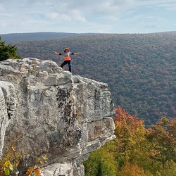
Great elevation gains, decent views, fun rock formations, Buzzard rock was impressive. I would have skipped the trail past buzzard since there wasn’t much of a viewpoint. Plenty of open areas for camping.
★
★
★
★
★
Great hike along cascading waterfalls. The hike is near the water most of the way. Lots of climbing up stairs and rocks.
★
★
★
★


This is a nice low-elevation gain loop that is doable in 2 hours. My regular exercise loop. This version of the loop keeps you off Turkey Pen trail which is a fairly ugly forest road as much as possible
★
★
★
★
Going up is a tuff one but the views are spectacular, good work out on this one
★
★
★
★

Always a great hike, especially this time of year when I can chat with thruhikers.
★
★
★
★
★

This is a fun trail, but note that it is closed in the middle. There's two ways to access, but both will be down-and-backs due to the closure and lack of connecting spurs.
Enter from Crabtree:
This route will take you from Meadow Lane in Tyro onto the northern end of Shoe Creek. The Crabtree portion is basically a gravel road with some small rocks until you pass the Crabtree parking lot (.5 miles from the falls) and transition to the northern edge of Shoecreek. Instantly you'll start seeing some rocks, mud, and ruts. There's two decent obstacles though they have paths around them.
The other option is to take the southern entrance from Perkins Mill Road, where the driving directions above lead. This path is easier. Muddy and rutted with several water crossings and swimming holes. You'll make it roughly 2 miles in before you'll see the No Trespassing sign. A few hundred yards ahead of that there's a locked gate. I'd suggest turning around at the first fork after the sign.
If hitting either of these trails, look out for the Chicken Coop on 29 and Mac's Country Store on 151. Both have excellent fried chicken.
★
★
★
Most of this road is now paved. However, it's a fun, windy shelf road. Several spots for good views and three small waterfalls.
★
★
★
The hike up The Priest is strenuous and the walk along Crabtree Falls Hwy is tedious, but it’s still a great loop. Highlights include a walk through an inexplicable stretch of pollinator food plants between The Priest and the keep trail to CTF
★
★
★
★
Amazing vistas, a beautiful ridge-top white oak savannah and mature poplars along May-Har stretch. You can even cool off in Campbell’s creek. Head up to Three Ridges first as the uphill climb from Harper’s Creek is brutal.
★
★
★
★
★

This is a great out and back but can be linked to the Tuscarora for a loop hike. Some parts of the trail are very rocky so progress is slower. If you continue on past Signal Knob it’s a gravel road walk for a while. No water available past Elizabeth Furnace.
★
★
★
★

Great 20ish mile gravel loop. Good hard packed chat surface with great ups and downs. Lots of dispersed camping opportunities along the route. Plenty of stream water.
★
★
★
★
★


Easy access from BRP. Well maintained Forest Svc road 306 to AT. Plenty of prepared camp sites with both metal and rock fire pits and loose small gravel grand cover. Fantastic views.
★
★
★
★

Moderate loop. Falls were nice. Way finding typical (not great). Hiked it Nov 2020. Start from White Rock parking lot and head towards Slacks trail. When you get back to the parkway and overlook, head south on the road to find the trail again.
★
★
★
★
★

Really great hike along a river with lots of swimming holes and camping spots about 2 miles from the parking spot for St. Mary’s Wilderness.
★
★
★
★
★

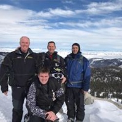
Pretty tough for 45 year old dad-bods! Doable but you’ve got to want it. Nice overlook about 2/3 of the way. The last 1/3 was harder than I was hoping after struggling through the first 2/3.
Priest overlook is apparently just after the map waypoint. Just off the trail to your right. Amazing view!
Back half, down to Crabtree Falls, is easy until the last ~1.5miles, which is pretty downhill and burns the quads.
Crabtree Falls were just ok. Looking Glass and Cascades Falls are better IMO.
Took us 6.5hrs to get to our pre-parked car, but we are in average to below average shape for 45 year olds.
★
★
★
★

This was an amazing hike but I really find it hard to believe that people can do it and really enjoy it by being done in 6 hours. So many amazing sights but was a pretty tough hike.
★
★
★
★
★

Nice views with some pretty crunchy terrain. Bogs are fun but beware, after lots of rain fall easy to get stuck.
★
★
★
★
★

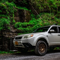
This trail was a blast. Had no issues tackling it in a stock JLU Sport S. Just need to be experienced enough to attack the obstacles and picking the right lines.
★
★
★
★
★
 stars
stars
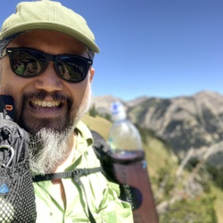
Solo hike! This was one of the most difficult hikes I have ever done. I started at the left side of the parking lot and hiked the route clockwise. I liked going that way because the climb was steep at the beginning while I was fresh. The views were great, one small waterfall and seeing the TV station/tower was pretty cool. I went while the mountain laurel was blooming and it was a sea of white blossoms! Definitely take plenty of water (I ran through almost 100oz) and hiking poles. Lots of rock scrambles but the trail is well marked.
★
★
★
★
★
Counterclockwise seems to be the better way to go. Good vistas and change of scenery, but really heavy traffic on the way to Signal Peak.
★
★
★
★


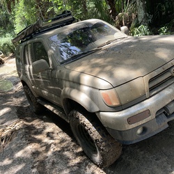
Great off road trail, Requires 4x4 vehicle’s. Plenty of pull offs for camping. Closed Jan-Mar due to off road conditions.
★
★
★
★

Great Jeep trail. It’s a moderate rate trail with a lot of rocks and mud puddles. They say stock friendly but I’d disagree and say you need some clearance to through some of the mud holes.
★
★
★
★

Enjoyed this hike in the fog today. We didn’t quite get the whole hike completed because of the weather and the young ones but we basically had the trail to ourselves vs. Crabtree or Three Ridges, just north of us. Not too hard in terms of elevation for kids.
★
★
★
★

It takes some effort but the views from the tops, including Spy Rock and Cole Mountain, along with the spring wildflowers and Crabtree Falls make this a wonderful hike. Highly recommended,
★
★
★
★