Three waterfalls. One that is epic. Fantastic views from the summit and while hiking through the burn scar. Remote and rarely used. Badly overgrown in the warmer months.
★
★
★
★
★

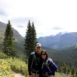
Beautiful hike. Amazing view at the top of the ridge at Cold Water Creek Shelter and the fire tower at Wesser Bald. Plenty of spots for water. The hike down is going NOBO from Wesser Bald is pretty challenging. Bring your trekking poles.
★
★
★
★
★

Wet Camp Gap is an area adjacent to the Mountains to Sea Trail near Rough Butt Bald. The area is filled with wildflowers and blueberries. The connector trail is rough with many loose stones and roots, but relatively short. The segment of the MTS proper is somewhat overgrown in places but mostly in good condition.
★
★
★
★
★

Santeelah Creek road passable up to Cherohala Skyway JUNE 27 2025. A few campers along the way. Some fresh trees down but nothing blocking the road
★
★
★
★

This hike was the hardest so far, only because of the severe heat 100 + degrees. It was very challenging because of the elevation gains and losses.
★
★
★
★
★

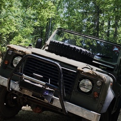
Great hike with medium difficulty. Lots of swimmers with 2 legs and 4. 🐾 Would recommend a vehicle with ground clearance, 4x4 isn’t necessary so long as it’s a dry day and you have a taller vehicle.
★
★
★
★
★


This hike does not show on Gaia, but does on AllTrails. It was a nice hike that led to a lovely overlook. To get to the overlook, stay to your right when the MST trail heads left (eastward?) it was a beautiful day - a little chilly, and the leaves were just at the end of peak. It’s an easy short hike at elevation. We did this and then found a spot on the Parkway to watch sunset.
★
★
★
★
★

Great hike from Fontana to Tapoco Lodge on the Benton Mackaye trail. The trail was in much better shape than I anticipated for this time of year. Already thinking how great a hike it will be this fall!
★
★
★
★
★

This is one of the best wildflower hikes for early April, but what would otherwise be a moderately difficult hike becomes much more difficult due to numerous tree, falls from dead hemlock
★
★
★
★
★

Nice trail with few obstacles. Beautiful “beach” area to have lunch. Waterfalls at bridge.
★
★
★
★

There are really only 2 serious climbs getting to the Hangover, one being up to the junction with Stratton Bald trail and the other one at the ascent up to saddle tree gap. Very well marked and the views at the hangover are some of the best in the east. Quite a few campsites along the way and apparently plenty of water sources according to locals, which I did not search for.
★
★
★
★
★


Let me share my story with this trail. I read about this trail in a book (can’t remember the book and I don’t have it anymore. I think I burned it and scattered the ashes in Fires Creek- j/k). It looked like a great trail for a weekend, I love ridges, and bonus -it’s a loop, so no shuttling, no backtracking. I also decided to bring along my friend, for his FIRST BACKPACKING TRIP.
Plan was to get to the trailhead Friday evening, hike the trail (clockwise) on Saturday and finish up by late Sunday. We stealth camped near the trailhead Friday night and set off in the morning. Didn’t take long to see that this trail is NO JOKE. Briars everywhere, crazy steep up and downs, and staying on the trail was hard. I think animals were using the trail more than humans – I saw LOTS of scat right on the trail (at the time, I wasn’t sure what kind of scat it was, but I find out soon enough).
We hiked all day Saturday. Water was so scarce we had to filter water out of a muddy puddle in a part of trail that apparently was an old road. And as the sun was getting low in the sky Saturday (late because it was July) the trail comes to a gravel forest road. A post was there that at some point probably had a very helpful trail sign – the sign was gone. No idea where the trail goes at this point. Can’t find it. We keep looking trying to pick up the trail…no idea. We were pretty low on water again, so we followed the road downhill for a mile to get to a creek. Filtered water and came back up to the where we left off.
So far, this hike isn’t what I was expecting. I made the call that we basically needed to bail and abandon the idea of finishing the trail. We would camp and go back out the way we came in the next day. So, we are a few minutes into backtracking, looking for a place to camp, I round a bend in the trail and something BIG AND BLACK runs across the trail into the Rhododendron. This part of the trial is on a narrow part of the ridge, so there was really no way to give this thing space. We had to go right past there in order to keep moving. As we got close, the animal sprang out of the Rhododendron and started jumping up and down, darting back and forth, snorting, and kicking up dirt. It was a wild hog. And it was super mad. He moved back into the Rhododendron, and we ran past as fast as we could, all the while that hog was making snorts and shrieks like crazy.
My poor friend was completely exhausted now, mentally and physically. I found a nice place to camp, pitched the tarp right as it was getting dark. I made some dinner on my stove and when I tried to give it to my friend, he was already asleep. We slept under my tarp up on the ridge, my friend snored bad and sometimes it would wake me up and I thought that hog was back!
Sunday morning, hit trail. When we were on a part of the trail that looked like an old roadbed, I noticed that it seemed even more overgrown than I remembered on Saturday. I put my concerns to rest when I kept seeing blazes – I must be on the trail, right? Wrong. I eventually knew it wasn’t right. I stopped and my friend asked me why I had a puzzled look on my face. I told him that I thought we had gotten off the trial somehow. I thought he was going to breakdown and start crying. I had him sit down and made him promise me he would stay right there. I started retracing my steps until I found my mistake. I retrieved my friend and we made it back to the trailhead late Sunday afternoon. What an adventure. Strangely, my friend would never go backpacking with me again. Not sure why. Be careful out there yall.
★
★

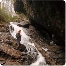
Beautiful drive along Big Snowbird creek beneath a canopy of forest on Big Snowbird Rd. Road Dead ends at the trail head which has 3 spectacular waterfalls along the hike.
★
★
★
★
★
The road along Big Snowbird creek is a drive through a rainforest canopy which ends at a hiking trailhead to Middle Falls, Upper Falls and Sassafras falls. Just an all around beautiful experience.
★
★
★
★
★


If you don’t mind getting your feet wet, this is the trail for you. Fantastic views from atop Big Scaly. Do it counter clockwise so you give your shoes time to dry out by the time you are back at the trailhead.
Don’t do this May - November. Overgrown and not well maintained trail. Maybe the reason why it’s not popular. Only other mammals we saw were wild pigs - which was incredible☺️
★
★
★
★
★

The loop was pretty packed with through hikers this last weekend and rangers added signage recommending bear cannisters because of the amount of bear activity and food stolen this last week. We were diligent and had no problems but we avoided camping at busy spots.
★
★
★
★
★


Nice, relatively easy out and back with some good winter views. Couldn’t find a good view from Gage Bald (which is pretty small), but Wet Camp Gap is always nice to visit in cold weather.
★
★
★

Took longer than anticipated, bee’s were abundant, but overall great hike
★
★
★
★
 stars
stars
Very nice hike along Appalachian Trail that features some long range views from Standing Indian mountain.
★
★
★
★

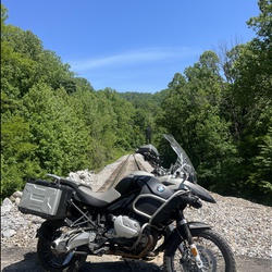
Great gravel roads. Little traffic
Mostly tight pack, fast gravel.
★
★
★
★

K the farm is a very tu
By B Bcgb FTC
FB
It CDs er nik mmt
It dad. F. N
B
We had c v be c the C. It was. The EV
★

Beautiful hike over various rugged terrains! HIGHLY recommended!
★
★
★
★
★


Amazing backpacking trail with great views from Albert Mountain and Standing Indian Mountain. Plenty of camping options throughout. If you’re looking for something challenging, this is it!
★
★
★
★
★

This is a hard hike. Ended up ~1.5 miles longer than expected. Steep initial climb, levels out a bit around creek camp, then up rest of the way. Plan for extra water given the workout. Slippery rocks and several creek crossings. But beautiful wildflowers, fungi, and views well worth it.
★
★
★
★
★


 stars
stars