One of the most beautiful trails I have ever hiked. Not that long. Not that hard. But impressive to me by the diversity of vegetation everywhere. We hiked this in mid November and there were so many plants around. It was almost impossible to count. Lots of mushrooms as well. Just absolutely gorgeous.
★
★
★
★
★

Stunning Selkirk views. Two lakes in one hike. Huckleberry picking, good fishing and nice camp sites.
★
★
★
★
★

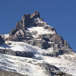
We bypassed the lake on the way up with our Mountaineers scramble group. Made it to Harrison peak through some bushwhacking and talus bouldering. Gorgeous views! Dipped in the lake on the way back. Not as cold as you’d think.
★
★
★
★
★

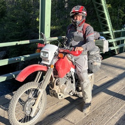
This is not a well maintained trail. Some local dirt bikers. Try to keep it clear, but it gets sketchy near the top. That said, ample huckleberries and scenery along the way.
★
★
★


Taken at a steady pace, this is a fantastic hike. Much of the trail is in the shade of the forest. Figuring out the trail is a little sketchy over the large granite slabs, so keep an eye open for the kairns that show the way. The lake is gorgeous. The mosquitos are annoying.
★
★
★
★
★


Remote hike in the N Fork of CDA River drainage. No humans, but lots of large mammals in the area - moose, elk, bear, deer, eagles, beaver and much more. Challenging scramble down to rivers edge to beautiful and unspoiled fishing holes. Heavy rain/hail and wind increased challenge but added to mystic.
★
★
★
★
★

Lots of steep pitches going up and back. Well worth it. The view is like no other
★
★
★
★

On a sunny fall day, this is a spectacular hike with views of all the mountains in our area and into Montana.
★
★
★
★
★

This hike was from West Fork Cabin to Hidden Lake trailhead. Hidden Lake is largest mountain lake in Boundary County Idaho. West Fork Cabin is first come first serve.
★
★
★
★
★

Great place for dirt bike riding. So many options and trails with various difficulty of trails. Come and find out
★
★
★
★
★

Road to trail is narrow and rough 4wd needed. The trail is a motorized trail so is steep and rough. At the top I bushwhacked back down a ridge to the lower portion of the trail.
★
★
★
Route from priest Lake to Pend Oreille River north of Usk. Good loop to complete heading from Priest around to Metalline Falls and back. Great day trip! Side stop at S Baldy Lookout. Great day, lots of wildflowers
★
★
★
★
★

This is a very beautiful, challenging hike! There is not a single flat or down sloping section of the trail once you get started. My first time on this trail was in late June and there were flowers everywhere in the lower 2/3 of the trail. In late June we encountered quite a bit of snow on the upper 1/3 of the trail in the trees. Once our of the trees, in the top 1/3, there was no snow. Views along the way and at the top made every step of this hike worthwhile.
★
★
★
★
★

This is a really great hike in a beautiful part of the Sellkirk range. The upper section is a little tricky to navigate as it moves across some large sections of sloped granite, so look for the cairns. I measured it at 3.6 miles twice so I'm not sure about the accuracy here. Beehive lake is incredibly beautiful and a fun launching spot for lots of rock scrambling opportunities. Would definitely recommend for first time backpackers or anyone looking for a really great day hike.
★
★
★
★

Epic describes it best. Loved the historical markers along the way. Great views from the trestles and elsewhere. Cold, dark tunnels with shower surprises along the way.
★
★
★
★
★

Great views, but super chopped up from Moto-Bros who, as a group, seem to lack common sense and courtesy.
★
★
★


Great track and was spot on ! Smokey when we went through but you could tell the vistas would be spectacular if the weather was clear.
★
★
★
★
★


Beautiful panoramic views at the peak. Not too difficult or long.
★
★
★
★

Starting from Mount Gleason down a spur to part of stateline #162. Traveled to the junction with #231 and then up to the USFS road 310
★
★
★
★

There are five alpine lakes within a few miles of each other. Size wise, this one falls in the middle. Pretty lake—deep silt bottom—normal number of summer bugs—small fish jumping.
The hike in is a moderate upward grade. Spring came late this year with lots of rain. Portions of the trail were overgrown. Water running down the trail. Several blow downs went across the trail, but nothing difficult to cross.
Enjoyable hike.
★
★
★
★
 stars
stars
We parked at the main trailhead, but you can easily drive another 1/4 mile up the road before accessing this trail. It is steep! But, it is so short that you are just in for a good workout. The rewards are beautiful flowers, waterfall, and an amazing lake--time it for lunch! Poles certainly help on the way down. This trail is far less travelled than the adjacent Stevens Lake.
★
★
★
★
Good moderate trail. Can be muddy. Would be good for kids. Lots of shade.
★
★
★
★


Great hike. Not as steep and long. Gorgeous Cedars!!! Recommend Highly 😊😊
★
★
★
★
★

Good road to trailhead. Several logs over trail, but good shape overall. Fantastic 360 degree view
★
★
★
★
★

Beautiful ride with lots of tunnels to go through and bridges to cross. We started in Wallace and found ourselves in Avery. 30 miles one way. It’s best to stay on Moon Pass Road rather than the detour to the south. It was more of a rocky 4x4 road. Extremely dusty road when we went.
★
★
★
★
★

Awesome hike 4 miles round trip.
Lots of overlooks of the valley below.
★
★
★
★

 stars
stars
Such a great hike with both the mountain and lake feel. Not steep and well traveled.
★
★
★
★
★