United States
›
Colorado
›
Gunnison Gorge National Conservation Area

Best Hiking Trails in Gunnison Gorge National Conservation Area

21 reviews


link Copy Link email Email directions Driving Directions

Seasonal Popularity

Overview

Gunnison Gorge National Conservation Area is a protected area in Colorado.


  • Hiking Trails (11)
  • Reviews (21)
  1. 1
    North Sidewinder Trailhead via Sidewinder Trail
    ★ ★ ★ ★ ★ DIFFICULT 20.3 mi
  2. 2
    Sidewinder Trail
    ★ ★ ★ ★ MODERATE 6.8 mi
  3. 3
    West River Trailhead via West River Trail
    ★ ★ ★ ★ ★ EASY 1.3 mi
  4. 4
    Sunset Rocks Trailhead Loop via Sunset Rocks Trail
    ★ ★ ★ MODERATE 5.2 mi
  5. 5
    North Sidewinder Trailhead via Smith Mountain Road
    ★ ★ ★ ★ EASY 3.1 mi
  6. 6
    Gunnison Gorge National Conservation Area Hike
    ★ ★ ★ EASY 3.6 mi
  7. 7
    Chukar Geologic Trailhead via Chukar Road
    ★ ★ ★ MODERATE 6.9 mi
  8. 8
    Birthday Canyon Trailhead Loop via Smith Mountain Road and South River Road
    ★ ★ ★ DIFFICULT 12.2 mi
  9. 9
    Brush Point via Eagle Road
    ★ ★ ★ EASY 2.9 mi
  10. 10
    Chukar Trailhead via Chukar Road
    ★ ★ ★ ★ ★ EASY 2.4 mi
    user_profile
    EarthyMTBike6301 4 years, 3 months ago
    Ute with Becky (2/19/22, 10:39:53AM)
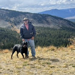
    Great hike, would do it again. We parked at the first lot and walked the road (2.5m) to the trailhead, due to some other reviews…while 4x4 is needed, it wasn’t nearly as bad as we expected and could have made it to the second parking lot at least. (By Sidewinder TH) Trail was clean, well kept and easy to follow. Great views, was a little snow (Feb19th) on the ground and definitely some muddy spots, saw a few people down at the campground, but pretty much had the place to ourselves.
    ★ ★ ★ ★ ★

    user_profile
    Thomas Hawwkins 1 year, 1 month ago
    Sunday Afternoon Activity
    ★ ★ ★ ★ ★

    user_profile
    NiceStone4246 1 year, 8 months ago
    Monday Afternoon Hiking
    ★ ★ ★ ★ ★

    user_profile
    elkram11 1 year, 8 months ago
    Gator
    ★ ★ ★ ★ ★

    user_profile
    Justo Valladares 2 years ago
    Black Canyon 1
    ★ ★ ★ ★ ★

    user_profile
    drochkes 2 years, 5 months ago
    Red Rocks
    ★ ★ ★

    user_profile
    GroovyGaiters4653 2 years, 5 months ago
    Track (12/5/23, 8:48:03AM)
    ★ ★

    user_profile
    ThWgdwT4 3 years, 1 month ago
    Track (4/15/23, 8:57:37AM)
    ★ ★ ★ ★ ★

    user_profile
    GroovyGaiters4653 3 years, 4 months ago
    Smith Mtn. River view
    ★ ★ ★

    user_profile
    Craig Harris 3 years, 11 months ago
    Track (6/14/22, 3:33:16PM)
    ★ ★ ★ ★ ★

    user_profile
    FaintCliff2907 5 years ago
    Track (5/21/21, 1:53:54PM)
    ★ ★ ★ ★ ★

    user_profile
    FaintCliff2907 5 years ago
    Track (5/21/21, 10:18:36AM)
    ★ ★ ★ ★ ★

    user_profile
    WiseLeaf7419 5 years ago
    Peach Valley OHV
    ★ ★ ★ ★ ★

    user_profile
    paulandjill 5 years ago
    Montrose County to Flat Top OHV Staging Area, Montrose County, CO, USA
    ★ ★ ★ ★ ★

    user_profile
    Antonio Gonzalez 5 years, 1 month ago
    Massacre Hill Loop
    ★ ★ ★

    user_profile
    Konrad Klausner 5 years, 2 months ago
    Ute Trail - Black Canyon of the Gunnison
    ★ ★ ★ ★ ★

    user_profile
    kbergie 5 years, 2 months ago
    Track (11/14/20, 10:41:26AM)
    ★ ★ ★ ★ ★

    user_profile
    DearMoss4237 5 years, 5 months ago
    Track (12/6/20, 11:27:39AM)
    ★

    user_profile
    BriskLamp1492 5 years, 9 months ago
    Track (7/14/18, 5:00:53PM)
    ★ ★ ★ ★ ★

    user_profile
    CrispPoncho7707 6 years ago
    Track (5/25/20, 12:12:23PM)
    ★ ★ ★ ★ ★

    user_profile
    Dado 6 years, 3 months ago
    Sidewinder Trail
    ★ ★ ★ ★