Day 2
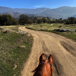
As I begin the climb, I get a good picture of Azalea Lk and Mount Emily on the right. Climbing higher I can see all the Red Buttes and even Emily. Eventually, I get to the pass with views to the west and have the closest ever view of Mount Prescott and El Capitan. On the next drainage, I get spectacular views of Buck Peak. It’s much prettier than the view this side. Yesterday, I walked up the Butte Fork of the Applegate River and today the first 3 miles takes me around the Middle Fork of the Applegate River. I’ll have to check and ask Brent if there are any other forks.
From where I stood, Cedar Creek wood flow into Thompson Creek which flows into the Klamath River.
I end my hike, a little less than 4 miles at the pass where I continued I would get to Sucker Creek Gap. here there is an amazing view of Pyramid Peak, but I can’t quite see Arnold because a small butte is in my way. Heading back to camp at about 1230 and it’s getting a little bit warmer.
I came back down the switchbacks below the ridge that looks down over the middle fork. I see a trail off to the left. That surely goes to that lush meadow—Probably for hunters. Got a nice picture of Buck Peak from this side and on the right, you can see the gap that I’ll cross over to the other side. Coming down after the pass I explore a wet meadow filled with various lilies (Asphodel?). Ended up being a 7 1/2 mile day with close to 1400 feet of elevation gain.
★
★
★
★
June15, 2025 Father’s Day Hike
Horse Camp TH to Cook and Green Mtn and Echo Lake
Cool 9:00 AM starts at trailhead.
Good trail and steady climb along creek through oak and Sugar Pine. Views of late snow come quick with Fruit Mountain and some ridges in front of Red Butte. Arnold off to the west.
Lots of flowers with some new varieties (Snowplant, wintergreens, coralroots, Triteleias, ), and Washington Lily in full bloom.
Just keeps climbing! Towards the top, the trail becomes faint but is easy to follow on Gaia. Flowers continue to abound! I’m getting close to the lake and 3600 feet of elevation gain in four miles. Lots of snow on the trail across the camber made going sketchy so I cut straight up the rocky slope and missed a lot of that hazard.
Met an Ashlander on the PCT at the top who is camping at Lonesome Lake tonight and doing the Horsecamp Loop. He was impressed on my Echo Lake trip coming up because of the elevation. He parked his car close to Cook and Green and didn’t have to worry about too much elevation gain, ha ha. He said Azalea Lake is good (bigger with lots of campsites), but Lonesome is better and there is never anybody there. He said Towhead Lake close to Lilypad Lake is also good.
Hike down was good but taxing. I was able to do the run/jog in a few trail sections but very tired back at the car. An evening of thigh cramps will await me
★
★
★
★

Hiked at the end of July. Great hike, well-maintained trail. Scramble was a bit of a challenge, especially for my 5' 0" self, but was able to do it without too much time spent on hands and knees.
★
★
★
★
★
Saturday, June 22, 2024. Late 10am start at the base of Dutchmans Peak. Heading up 40 S01 around Observation Peak. The smoke is visible in the valley and obscures a lot of the faraway peaks around this point. I can see Shasta and Mount Eddie, snowcapped to the south and other familiar peaks to the west. Hope to get some better pictures of them from higher up.
Lots of snow on the side of the road and creeks flowing. Beautiful wet, spring wildflowers like buttercup. Leave the exposed high view area and duck into the woods to see Mountain Hemlock and White? Fir as the dominant trees.
At some point, I realize this loop around Observation is going to be much longer than I anticipated, so I take a side road that heads up the peak and plan a shortcut to the PCT. The path up is riddled with off-road damage, but the roads end before the ridge so I just keep continuing up through manzanita type Kinnikinnick and lots of buckwheats.
Looking for a shortcut to the PCT I noticed I can get close to the peak and traverse down an open slope, and unfortunately it is covered in snow. Snow seems to be getting in my way a lot today. Ha ha, I can’t imagine being a through hiker!
Get back to the car pretty quickly and decide to take 2030 (Applegate Rd) down to Buncom instead of 22 to McKee Bridge at the Applegate. It’s very slow going, not really meant for a car, but my Forester seems to handle going down the road pretty well though I would not want to come up this way. I see the fire at Buncom and get some video of smoke and flames. Seems to be BLM land above the farmland, and there are helicopters and tanker planes dropping fire retardant on it
★
★
★

This was a great hike, and for only the 3 and a half miles, your whole family could go. Seriously, I got all the way there and there was kids.
★
★
★
★

7-3-20. This was a wonderful trip. We hiked into Grizzly Meadows. The larger campsites are on the right side of the creek as you approach the falls. It’s hard to see the campsites. Look signs of people crossing over. There are many but not obvious. There are campsites at the lake. That means you have to lug your gear up the step trail to the lake. Include time to hike one of the peaks, 3-5 hours. The lake was chilly but doable. Most of the snow from the mountains had melted. I’ve been told it is one of the nicest hikes in Trinity. The falls are beautiful.
★
★
★
★
★

Moderately intense since the first half is all uphill at a good incline. Most of the switchbacks are exposed but once you get past those it’s fairly flat with just a couple more hill sections.
★
★
★
★

Amazing landscape, beautiful wildflowers.
The climb from emerald lake to sawtooth ridge (towards caribou lake) is brutal
★
★
★
★
★
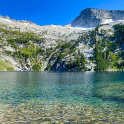
Views of Mt Shasta and the Red Buttes were spectacular. Stopped at the Echo Lake viewpoint. Stunning. Had a picnic there and a nap.
★
★
★
★
★