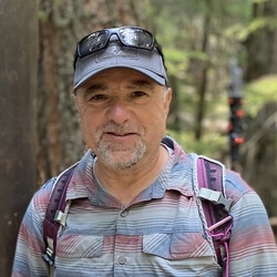
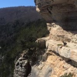
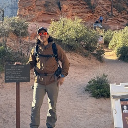
United States
›
Arizona
›
Saguaro National Park

Best Hiking Trails in Saguaro National Park

139 reviews


link Copy Link
  • facebookFacebook
  • Twitter iconTwitter
  • emailEmail
directions Driving Directions

Seasonal Popularity

Overview

Arizona's Saguaro National Park is known for two things: its vast forest of 100-year old saguaro cacti, and its incredible diversity of terrain. Here, the park's 150-mile network of trails crosses everything from desert scrub to pine forest to snow-capped mountains. That makes Saguaro a true four-season destination.

Come here to hike, camp, examine 1000-year-old petroglyphs, or scout for wildlife. In addition to critters native to the park's namesake desert ecosystem, Saguaro is home to black bears, mountain lions, bobcats, and coati.

Getting Started

The wild, primitive nature of Saguaro National Park is part of its appeal. It also means that amenities are a little sparser here than in other national parks.

For example, car camping is not possible anywhere in the national park; no campsites are accessible by vehicle. However, if you have a tent and are willing to do a little hiking, you can apply for an overnight permit at any of the six designated campgrounds, or secure a wilderness permit and plan a backpacking trip for even more solitude.

This park is split into two districts, situated on either side of the city of Tuscon.

Tuscon Mountain District

The western district is smaller in area and lower in elevation. It's home to some of the larger stands of saguaro cacti.

To get a taste of the region, try one of the area's more popular out-and-backs: Start at the West Camino del Cerro parking area and climb the Sweetwater Trail about 1,000 vertical feet over 3.4 miles. From there, head north to tag Watson Peak, or stop before the turnoff and retrace your steps back to the parking area.

Rincon Mountain District

The eastern district is larger and more biologically diverse, and includes a number of peaks over 8,000 feet tall. Head to these high-elevation "sky islands" in the summer to find cooler temperatures.

If you're headed here, the 5.9-mile Carrillo Trail and Douglas Spring Loop is a great place to start. For a bigger adventure that takes you into serious Rincon hill country, tackle the 13.4 mile, 4,800-foot climb to Manning Camp. Stay a night (or two) and hike out the way you came.

If you're local to the area (although visitors can apply, too), Saguaro National Park offers a unique volunteer opportunity to survey saguaro in difficult-to-access parts of the park. Volunteers have the opportunity to observe, measure and plot GPS coordinates of the cacti.

When to Go

While the range of elevation in Saguaro means you can find something to do here any time of year, keep in mind that you still have to pass through the lowlands to get up high, and summer temps in Tuscon frequently exceed 100°F. For that reason, most visitors come between November and March to take advantage of the mild winter weather. If you do decide to visit during the summer, head to the mountains, or time your trip between April and June to catch the saguaro cactus gardens in bloom.

Permits

Saguaro National Park currently charges day-use fees for admission. It also accepts annual and interagency passes. Current costs are available on the park's passes and fees page.

Permits are required for any overnight stays in the park.

Dog Info

Pets are allowed only on paved trails and in some picnic areas. This is in part to protect pets from hazards like rattlesnakes and cactus spines, and in part to preserve the park's sensitive ecosystems.


Resources

  • nps.gov
  • wikipedia

  • Hiking Trails (63)
  • Reviews (139)
  1. 1
    Wasson Peak Loop via Hugh Norris Trail and King Canyon Trail
    ★ ★ ★ ★ ★ MODERATE 7.5 mi
  2. 2
    Douglas Spring
    ★ ★ ★ ★ ★ MODERATE 7.2 mi
  3. 3
    Wasson Peak via Hugh Norris Trail
    ★ ★ ★ ★ ★ DIFFICULT 9.5 mi
  4. 4
    Mam-a-Gah Loop via Gould Mine Trail and King Canyon Trail
    ★ ★ ★ ★ ★ EASY 2.4 mi
  5. 5
    Wasson Peak via Hugh Norris Trail and Sendero Esperanza Trail
    ★ ★ ★ ★ ★ MODERATE 7.5 mi
  6. 6
    Mam-a-Gah via King Canyon Trail
    ★ ★ ★ ★ ★ EASY 2.9 mi
  7. 7
    Douglas Spring Trailhead via Douglas Spring and Three Tank Trail
    ★ ★ ★ ★ ★ MODERATE 5.9 mi
  8. 8
    Wasson Peak via King Canyon Trail
    ★ ★ ★ ★ ★ MODERATE 6.9 mi
  9. 9
    Wasson Peak via Sweetwater Trail
    ★ ★ ★ ★ ★ MODERATE 4.5 mi
  10. 10
    Apache Peak Loop via Hugh Norris Trail
    ★ ★ ★ ★ ★ MODERATE 6.4 mi
    user_profile
    timlapira 2 weeks, 3 days ago
    Cactus Forest Trail
    I. Mmm
    ★ ★ ★ ★ ★

    user_profile
    Hiker709 2 weeks, 5 days ago
    Wasson Peak via Hugh Norris Trail and Sendero Esperanza Trail
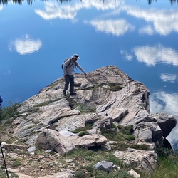
    This is a very delightful hike on good trails. Unlike canyon hikes, this hike has minimal rock and boulder scrambles. After a mile long trek from the trailhead on flat, sandy ground the trail climbs to a high ridge where it intersects the Hugh Norris trail. This trail travels on relatively smooth dirt along a high ridge with beautiful long range 360 degree views of the Tucson area. Generous switchbacks moderate the climbs so it’s very comfortable for most hikers.
    ★ ★ ★ ★

    user_profile
    kugler796 1 month ago
    Cactus Forest Trail
    Qa
    ★ ★ ★ ★ ★

    user_profile stars
    sinarcsin 3 months, 1 week ago
    Cactus Forest Trail
    This is a nice easy trail, mostly level, and suitable for hikers of all skill levels. There are a number of locations where you can access trailheads, for this hike, such as from Mica Picnic area, from the park loop drive Cactus Forest Floor Trailhead and from an entrance just of off Broadway Boulevard. The trail from Mica Picnic area to the Broadway trailhead is blacktop for easy going. Continuing clockwise from the Broadway Trailhead the trail is a mix of sand, rocks and cactus. Beautiful scenery everywhere you look. Enjoy the Saguaro Cactus as you loop around to your starting point. If you do decide to go further the loop trail does intersect with a number of other trails so you are able to create larger loops especially to the northeast. Also located in the immediate area is the Desert Ecology Trail with is interpretive paved trail suitable for everyone. As with all hiking made sure you bring plenty of water, pay attention to the temperature in the summer months, and enjoy the outdoors and the Saguaro Cactus.
    ★ ★ ★

    user_profile
    troylozar 3 months, 2 weeks ago
    Track (2/1/22, 11:01:19AM)
    Nice hike. Well marked. Could jog it if you are confident at cross country. Summertime conditions can be dangerous. Beautiful natural tanks should be running in Spring mostly, but some water in winter.
    ★ ★ ★ ★ ★

    user_profile
    Mattie 5 months, 1 week ago
    Steve & Lance Hike
    Easy hike and beautiful weather this time of year. Expansive views of the desert and city. Mild incline at the start.
    ★ ★ ★ ★ ★

    user_profile
    jmlunt 6 months, 1 week ago
    Track (11/7/21, 06:48:18)
    Awesome trail! Beautiful views and easy to navigate.
    ★ ★ ★ ★

    user_profile
    Lee S. 7 months, 2 weeks ago
    Douglas Spring Trailhead loop
    Saguaro National Park, near Wild Horse Canyon. Beautiful desert scenery! Several trailheads in this area to park your, link several trails together to make this (or a similar) loop.
    ★ ★ ★ ★ ★

    user_profile
    amber.wright 8 months ago
    Track (9/20/21, 6:06:05AM)
    Popular trail system at Eastern edge of Tucson. After major monsoons this summer, the grasses along 3 tanks trail were thick and tall, some above my head.
    ★ ★ ★

    user_profile
    Karen 1 year ago
    Mica View - Cactus Forest - Mesquite - Loma Verde - Cholla - Cactus Forest - Shantz
    A bit longer but still easy hike compared to the popular loops out of Broadway Trailhead, with a variety of habitats. Very quiet today except for a large reddish snake that made a quick exit. I passed nobody else on the trails at all.
    ★ ★ ★ ★

    user_profile
    lilnibs 1 year, 1 month ago
    Track (4/11/21, 7:56:16AM)
    beautiful views and a great work out.
    ★ ★ ★ ★ ★

    user_profile
    my4bayhorses 1 year, 1 month ago
    Gila Mine Ride3/22/21, 1:37:58PM)
    Trail to mine was average rocky for the area, some exposure down to a canyon some of the way. Narrower trail than the others we’d been on. The Brittlebrush trail down to the main trail was really tricky- lots of cholla close to the trail and much narrower, not as horse friendly. Also a couple very tricky rocky downhill spots . One I got off for but Dave stayed on and it was ok just seemed too steep. Once down in the wash is was fine, and a relief!
    ★ ★ ★

    user_profile
    zkeene18 1 year, 2 months ago
    El Camino del Cerro Trailhead to Wasson Peak, Pima County, AZ, USA
    Gorgeous views, manageable gain and grade.
    ★ ★ ★ ★ ★

    user_profile
    Karen 1 year, 2 months ago
    Cactus Forest to Shantz via Mica View Road
    The longest of the 3 easy loops from Broadway Trailhead has some variety of terrain and several iconic and oft-photographed saguaros. Restroom available at Mica View Picnic Area.
    ★ ★ ★ ★

    user_profile
    Karen 1 year, 2 months ago
    Mica View - Cactus Forest - Mesquite - Loma Verde - Cholla
    Almost exactly four miles on a windy but pleasant day. A variety of terrains and plant life, nothing difficult but some trenches (and I fell near a wash). Really good hike if you have more time than hiking skills.
    ★ ★ ★ ★

    user_profile
    Karen 1 year, 2 months ago
    Loma Verde - Cholla - Cactus Forest - Mesquite loop(2/26/21, 5:03:12PM)
    A little shorter loop than expected but the weather was perfect and the scenery was great as usual. This loop has a number of especially large and impressive saguaros.
    ★ ★ ★ ★

    user_profile
    hikerj 1 year, 2 months ago
    Tucson Mountain park el Camino Del Cerro TH
    Open Saguaro country, easy hike, great views. No shade.
    ★ ★ ★ ★

    user_profile
    jsblakley 1 year, 3 months ago
    Wasson Peak via King Canyon Trail
    The view at the top was totally awesome.
    ★ ★ ★ ★ ★

    user_profile
    Karen 1 year, 3 months ago
    Garwood- Wildhorse - Shantz
    I forgot to resume this track after unexpectedly finding myself coming onto Shantz Trail after a wrong turn. Total distance including the unrecorded trek back to the car = 2.6 miles. A bit more work than the very easy trails from the Broadway Trailhead. Being semi-lost at dusk was less than ideal. Beautiful as usual.
    ★ ★ ★ ★

    user_profile
    shedberg1 1 year, 5 months ago
    Douglas Spring Trailhead, Tanque Verde to Converse, Pima County, AZ, USA
    Fun and very desert-picturesque hike from the end of Speedway up to Bridal Veil Falls. Around 1000’ feet elevation gain and very nice trail all the way.
    ★ ★ ★ ★ ★

    user_profile
    Utah_Rookie 1 year, 6 months ago
    Carrillo Trail and Douglas Spring Loop
    This is a great 6nmi early season easy hike (for snowbirds), with only 750' of elevation gain. A bonus is seeing a Crested Saguaro along the trail. I'll post a picture later.
    ★ ★ ★ ★

    user_profile
    Mike Barcom 1 year, 7 months ago
    Douglas Spngs Carillo Loop
    Z belmrtm
    ★ ★ ★ ★ ★

    user_profile
    Karen 1 year, 8 months ago
    Valley View Picnic Area (historical) to Signal Hill, Pima County, AZ, USA
    I turned around after 2/3 of a mile because a storm was coming and lightning, although miles away, was worrying. Will come back after monsoon is over.
    ★ ★ ★

    user_profile
    hector157 1 year, 9 months ago
    Track (7/24/20, 10:15:24)
    It was an awesome hike but due to dry creek the waterfall weren’t that exciting to see. Need go when it’s raining season.
    ★ ★ ★ ★

    user_profile
    Karen 1 year, 10 months ago
    Broadway Trailhead to Pink Hill Lookout (7/17/20, 6:25:51PM)
    I wanted to know where the Pink Hill was, per the name of the trail, and whether it was pink, and whether you could get there, and whether there was anything to see. Yes, you can get there, yes, the dirt is kind of pink, and yes, it’s a beautiful short hike and a nice view at the end, albeit not spectacular. Recommended for “easy” hikers.
    ★ ★ ★ ★

    user_profile
    Karen 1 year, 10 months ago
    Cactus Forest Trail from Mica View to Cactus Shack (7/10/20, 6:45:05PM)
    This was just me closing the gap between my hikes from the north end of Cactus Forest Trail and my hikes from the south trailhead of the same trail. I left from Mica View Picnic Area and hiked past Cactus Forest Drive and the foundation (ruin) of the Cactus Shack. Not the most dramatic part of this trail but it’s easy going and parallels the Rincons.
    ★ ★ ★ ★

    user_profile
    Karen 1 year, 11 months ago
    Cactus Forest Trail past Lime Kilns
    2 miles up from the south trailhead on Cactus Forest Drive, 2 miles back. Some climbing but nothing too difficult or treacherous. Last half mile past the Lime kiln is basically flat. No shade to speak of.
    ★ ★ ★ ★

    user_profile
    Karen 1 year, 12 months ago
    Track (5/23/20, 6:12:38PM)
    An oddball hike because I left my phone on the roof of my car and went back for it, which ate up some time so I took a shorter route, only to detour at the end to fill out 3 miles. Turns out not all trails in this part of the park are alike in terrain. Creosote Trail has steps down into a shallow canyon. Kennedy Trail is a straight line on the map but up and down in real life. Both have dramatic views. Stock Bypass and Shantz are both sandy in spots.
    ★ ★ ★ ★

    user_profile
    Karen 1 year, 12 months ago
    Shantz to Mica View to Cactus View
    Just a way to do an easy 3.33 mile loop from the Broadway trailhead without using the paved part of Mica View.
    ★ ★ ★ ★

    user_profile
    Karen 2 years ago
    Douglas Spring Trailhead, Tanque Verde to Stock By Pass, Pima County, AZ, USA
    This was the usual Douglas Spring - Garwood - Wild Horse Loop with a little detour into the Shantz Trail at the end. Saguaros are starting to bloom. It’s hot but wasn’t too bad this evening (6 PM).
    ★ ★ ★ ★

    user_profile
    Karen 2 years ago
    Pink Hill, Loma Verde, Cholla Loop
    It’s starting to get uncomfortably hot even as late as 5:45 PM. This loop has a little shade but not enough to counter late spring heat. Primarily saguaros, cholla and Palo Verde trees. Still beautiful and interesting. Saguaros are days away from blooming. Actual loop from parking is about 3.4 miles but I continued up Shantz Trail a short distance for sunset photos.
    ★ ★ ★ ★

    user_profile
    Karen 2 years ago
    Broadway Trailhead to Mica View Trailhead, via Loma Verde & Mesquite Trails
    This is the longest loop I’ve done to date in Saguaro NP: rated 3.7 miles on another app but closer to 4 miles. It’s also the prettiest loop. Some rocky bits, especially during elevation gain, but lots of flat ground and a fair amount of shade, which is important in mid-spring. Terrain changes several times. Watch for bees.
    ★ ★ ★ ★

    user_profile
    Karen 2 years ago
    Douglas Spring Trailhead, Tanque Verde to Garwood Trail, to Wildhorse Trail
    A smidge more rugged than the trails off the Broadway trailhead and there’s less shade. Still an easy 2.32 mile hike and beautiful. Saguaros are beginning to bloom but heat is beginning to oppress.
    ★ ★ ★ ★

    user_profile
    Karen 2 years ago
    Broadway Trailhead to Javelina Wash, Pima County, AZ, USA
    .7 miles of this easy loop is paved. Good side of this is that the hot pavement attracts lizards (and snakes). Very pretty, but it gets hot in late spring and summer. ‪Two miles in 100 degree weather at 5 PM (with pavement and almost no shade) is less pleasant than 3+ miles (no pavement, some shade) in 90-something degree weather at 6 PM on other trails nearby.
    ★ ★ ★ ★

    user_profile
    Karen 2 years ago
    Shantz, Pink Hill, Loma Verde, Cholla, Cactus Forest Trails
    The loop I wanted to take earlier in the week but didn’t have enough time. Beautiful and easy and fun. Only passed ONE person, on a Saturday!
    ★ ★ ★ ★

    user_profile
    Karen 2 years, 1 month ago
    Freeman Homestead Trail
    Easy, short, and beautiful. On different hikes I’ve seen a tortoise and a great horned owl.
    ★ ★ ★ ★

    user_profile
    Karen 2 years, 1 month ago
    Cactus Forest Trail to Saguaro Sisters
    Passed 12 people today, all with good social distancing: 3 couples, 2 families of 3. Well, it is a Saturday, and Road is closed next week.
    ★ ★ ★ ★

    user_profile
    Karen 2 years, 1 month ago
    Cactus Forest Trail to Dead End Trail
    Hurried a little this time. Very familiar trail for me. Only passed 2 couples with social distancing.
    ★ ★ ★ ★

    user_profile
    Karen 2 years, 1 month ago
    Cactus- Mica View - Broadway dead end
    Easy, reasonably pretty Trail, not overcrowded.
    ★ ★ ★ ★

    user_profile
    gatorgrad 2 years, 2 months ago
    Bridal Wreath Falls via Douglas Spring Trail(3/1/20, 8:11:33AM)
    Great moderate out and back hike. Close to town. Start early if you want to park near the trail head. Easy to follow trail. Terrain/grade varies. Trail was more crowded on our hike back late morning to mid day. The turn to Bridal Wreath falls is 2.7 miles up the Douglas Spring Trail, well depicted on the Gaia base map. The falls is another .3 miles off the Douglas Springs trail. To reach the pond at the bottom of the falls, you will need to pass over large stones. Watch your footing.
    ★ ★ ★ ★ ★

    user_profile
    Tom 2 years, 2 months ago
    Saguaro NP East from Lima Verde Trailhead
    Easy hike but great flora. Good for all abilities IF everyone carries water!
    ★ ★ ★

    user_profile
    mlimbach22 2 years, 5 months ago
    Hugh Norris-Dobe Wash Loop
    Total elevation gain occurs in first 1.5 miles or so if going counter clockwise. Nice steps all the way up. After dropping into Dobe Wash trail it’s pretty flat with great scenery back to TH.
    ★ ★ ★ ★

    user_profile
    scott.ryan7914 2 years, 8 months ago
    Track (9/15/19, 8:14:39AM)
    Perfect hike for a rainy day. Minimal mud and great views of the misty Rincons.
    ★ ★ ★ ★

    user_profile
    gershom 3 years, 2 months ago
    Not too steep, nice views. There still was some snow on the north-facing slopes on Feb 24. Must be brutal in the heat of summer.
    ★ ★ ★ ★

    user_profile
    kitford53 3 years, 5 months ago
    While the climb to Wasson Peak is challenging, the views at the top are well worth the effort. Will definitely go again with more friends!
    ★ ★ ★ ★ ★

    user_profile
    tapler2000@gmail.com 3 years, 6 months ago
    Easy but picturesque trail with a few petroglyphs along the way.
    ★ ★ ★ ★

    user_profile
    TheDudeRich 2 weeks, 5 days ago
    Saguaro National Monument East
    ★ ★ ★ ★

    user_profile
    rjfarina 3 weeks, 6 days ago
    Douglas Spring Loop (4/21/22, 10:32:52AM)
    ★ ★

    user_profile
    mbodette 1 month, 1 week ago
    Track (1/30/22, 11:33:17AM)
    ★ ★ ★

    user_profile
    jennifer.lievois 1 month, 1 week ago
    AZT Day 8
    ★ ★ ★ ★ ★

    user_profile
    mpeyko1 1 month, 1 week ago
    Track (3/13/22, 09:10:34)
    ★ ★ ★ ★ ★

    user_profile
    martinwiggins1 1 month, 3 weeks ago
    Track (3/8/22, 7:35:45AM)
    ★ ★ ★ ★

    user_profile
    mxmom542722 1 month, 3 weeks ago
    Track (3/23/22, 11:19:12AM)
    ★ ★ ★ ★ ★

    user_profile
    mxmom542722 2 months ago
    Track (3/17/22, 9:29:44AM)
    ★ ★ ★ ★ ★

    user_profile
    rus101 2 months, 1 week ago
    Tanque Verde Ridge to campground
    ★ ★ ★ ★ ★

    user_profile
    imacowgirll 2 months, 1 week ago
    Track (3/8/22, 10:45:39AM)
    ★ ★ ★ ★ ★

    user_profile
    kleavitt953 2 months, 1 week ago
    Wasson Peak
    ★ ★ ★ ★ ★

    user_profile
    mkendrick9 2 months, 2 weeks ago
    Wesson Peak
    ★ ★ ★ ★ ★

    user_profile
    barnold 2 months, 3 weeks ago
    4-15-20 Broadway East Saguaro Park Tom & Britney
    ★ ★ ★ ★ ★

    user_profile
    robingayle 3 months, 1 week ago
    Wasson Peak via Hugh Norris Trail
    ★ ★ ★ ★ ★

    user_profile
    esposojp 3 months, 1 week ago
    Cactus Forest Trail
    ★ ★ ★ ★

    user_profile
    michaelhrycyk1 3 months, 2 weeks ago
    Trench/Beach Walk
    ★

    user_profile
    7972151 3 months, 4 weeks ago
    Track (2022-01-20, 10:09:10AM)
    ★ ★ ★ ★ ★

    user_profile
    gatorgrad 4 months, 2 weeks ago
    Hugh Norris Trail (1/3/22, 10:22:45AM)
    ★ ★ ★ ★ ★

    user_profile
    scottnamo 4 months, 3 weeks ago
    Wasson Peak Loop via Hugh Norris Trail and King Canyon Trail
    ★ ★

    user_profile
    Niki Dupree 4 months, 3 weeks ago
    Saguaro East-Ernie’sFalls 2 tanks loop (12/27/21, 10:50:55AM)
    ★ ★ ★ ★

    user_profile
    shawn.d.copeland 4 months, 3 weeks ago
    Loma Verde Trail to Saguaro Wilderness, Pima County, AZ, USA
    ★ ★ ★ ★

    user_profile
    Jeff 4 months, 4 weeks ago
    Track (12/22/21, 10:39:48AM)
    ★ ★ ★ ★ ★

    user_profile
    marq 5 months, 4 weeks ago
    Douglas Spring Loop
    ★ ★

    user_profile
    lotusartistries 6 months ago
    Track (11/14/21, 08:06:10)
    ★ ★ ★ ★ ★

    user_profile
    Turk 6 months, 4 weeks ago
    Track (10/21/21, 10:47:33AM)
    ★ ★ ★ ★

    user_profile
    25temery 7 months, 1 week ago
    Cactus Forest Trail
    ★ ★ ★

    user_profile
    Turk 10 months, 1 week ago
    Wasson Peak Loop via Hugh Norris Trail and King Canyon Trail
    ★ ★ ★

    user_profile
    ballisavery 11 months ago
    6: cam-boh trail
    ★ ★ ★ ★ ★

    user_profile
    hcfm 11 months, 3 weeks ago
    Track (5/17/21, 6:10:40AM)
    ★ ★ ★ ★ ★

    user_profile
    dg668489 11 months, 4 weeks ago
    Wasson Peak Loop via Hugh Norris Trail and King Canyon Trail
    ★ ★ ★ ★ ★

    user_profile
    chg1951 1 year ago
    Brittlebush Thunderbird Loop (4/25/20, 7:40:03AM)
    ★

    user_profile
    Karen 1 year ago
    Cactus Forest - Cholla - Loma Verde - Mesquite - Mica View Loop
    ★ ★ ★ ★

    user_profile
    lilnibs 1 year, 1 month ago
    Wildhorse Trailhead, Tanque Verde to WildHorse Trail, Pima County, AZ, USA
    ★ ★ ★ ★ ★

    user_profile
    aitkennicole 1 year, 1 month ago
    Rincon Peak
    ★ ★ ★ ★ ★

    user_profile
    mattgruca 1 year, 1 month ago
    Arizona-Sonora Desert Museum to Amole Peak, Pima County, AZ, USA
    ★ ★ ★ ★ ★

    user_profile
    dmclancy 1 year, 1 month ago
    Juniper Basin Campground Loop via Tanque Verde Ridge Trail and Douglas Spring
    ★ ★

    user_profile
    my4bayhorses 1 year, 1 month ago
    Saguaro West Ride (3/21/21, 8:59:05AM)
    ★ ★ ★ ★ ★

    user_profile
    patricktpaul47 1 year, 2 months ago
    Bridal wreath falls loop trail
    ★

    user_profile
    imacowgirll 1 year, 2 months ago
    Track (3/8/21, 10:18:30AM)
    ★ ★ ★ ★

    user_profile
    Rick Kroc 1 year, 2 months ago
    Wasson Peak via Hugh Norris Trail
    ★ ★ ★ ★ ★

    user_profile
    HeatherHiggins 1 year, 3 months ago
    Prophecy Wash Trail and Cam-Boh Trail
    ★

    user_profile
    tapler2000@gmail.com 1 year, 3 months ago
    2021-02-09 Wasson Peak via King Canyon Trail.
    ★ ★ ★ ★ ★

    user_profile
    controlbyrne 1 year, 3 months ago
    Cass n I hike 2-6-21
    ★ ★ ★

    user_profile
    fitnesscat5 1 year, 3 months ago
    Wasson Peak via Sweetwater Trail
    ★ ★ ★ ★

    user_profile
    teslalorraine 1 year, 3 months ago
    Bellota Ranch, Tanque Verde to WildHorse Trail, To Garwood damn
    ★ ★ ★ ★ ★

    user_profile
    jsblakley 1 year, 3 months ago
    Wasson Peak Loop via Hugh Norris Trail and King Canyon Trail
    ★ ★ ★ ★

    user_profile
    lindzlee93 1 year, 4 months ago
    Signal Hill Picnic Area, Pima County, AZ, USA
    ★ ★ ★ ★ ★

    user_profile
    Doug 1 year, 4 months ago
    Wasson via Sendero
    ★ ★ ★

    user_profile
    Christian Smith 1 year, 4 months ago
    Track (1/10/21, 8:42:52AM)
    ★ ★ ★ ★ ★

    user_profile
    nolan_luevano 1 year, 4 months ago
    Juniper Basin Campground to Chimenea Canyon
    ★ ★ ★ ★ ★

    user_profile
    nolan_luevano 1 year, 4 months ago
    Tanque Verde to Juniper
    ★ ★ ★ ★

    user_profile
    atomicman1 1 year, 4 months ago
    Bridal Wreath - 3 tanks loop
    ★ ★ ★ ★ ★

    user_profile
    controlbyrne 1 year, 4 months ago
    New Yrs Day hike w/Cass
    ★

    user_profile
    czhou79 1 year, 4 months ago
    Track (11/22/20, 8:59:15AM)
    ★ ★ ★ ★ ★

    user_profile
    luisagallagher 1 year, 4 months ago
    Squeeze pen trail
    ★ ★ ★

    user_profile
    beaster 1 year, 5 months ago
    Rincon Peak 1st Attempt
    ★ ★ ★ ★

    user_profile
    jmblanchard 1 year, 5 months ago
    Sweet water 12-18-20
    ★ ★ ★ ★ ★

    user_profile
    bertfromerhard 1 year, 5 months ago
    Petroglyphs in Saguaro West
    ★ ★ ★ ★ ★

    user_profile
    dsrobison 1 year, 5 months ago
    Track (11/28/20, 7:07:38AM)
    ★ ★ ★ ★ ★

    user_profile
    icecreamguy 1 year, 5 months ago
    Wasson from kings canyon
    ★ ★ ★ ★ ★

    user_profile
    mike.barnett 1 year, 5 months ago
    Douglas Camp Spring via Douglas Spring
    ★ ★ ★ ★ ★

    user_profile
    llohner 1 year, 6 months ago
    Wasson Peak Loop via Hugh Norris Trail and King Canyon Trail
    ★ ★ ★ ★

    user_profile
    thelastwillis 1 year, 6 months ago
    Wasson Peak Loop
    ★ ★ ★ ★

    user_profile
    Cory Keith 1 year, 7 months ago
    Manning Camp
    ★ ★ ★ ★ ★

    user_profile
    ronpieper08 1 year, 7 months ago
    Juniper Basin
    ★ ★ ★

    user_profile
    knips25 1 year, 7 months ago
    Tucson Mountain Wildlife Area to Sendero Esperanza Trail, Pima County, AZ, USA
    ★ ★ ★ ★ ★

    user_profile
    jay_yancick 1 year, 8 months ago
    Option 1
    ★

    user_profile
    apianta 1 year, 8 months ago
    Wasson Peak Loop via Hugh Norris Trail and King Canyon Trail
    ★

    user_profile
    wcdjmase 1 year, 8 months ago
    Trail Map to Mica Tank, Pima County, AZ, USA
    ★ ★ ★ ★ ★

    user_profile
    apianta 1 year, 9 months ago
    Saguaro Track (8/16/20, 9:08:55AM)
    ★ ★ ★ ★ ★

    user_profile
    Karen 1 year, 11 months ago
    Cactus Forest Trail to Shantz Trail
    ★ ★ ★ ★

    user_profile
    psjoquist 1 year, 12 months ago
    Wasson Peak via Sweetwater Trail
    ★

    user_profile
    radfordg 1 year, 12 months ago
    Track (5/21/20, 5:24:44AM)
    ★ ★ ★ ★ ★

    user_profile
    Karen 2 years ago
    Broadway Trailhead, Tanque Verde to Loma Verde Trail, Pima County, AZ, USA
    ★ ★ ★ ★

    user_profile
    mpheriot 2 years ago
    Track (6/2/19, 8:04:24AM)
    ★

    user_profile
    audrajashmore 2 years, 1 month ago
    Saguaro Park East
    ★ ★ ★ ★ ★

    user_profile
    r.hoose 2 years, 1 month ago
    Juniper Basin Campground to Freeman Homestead Trail, Pima County, AZ, USA
    ★ ★ ★ ★ ★

    user_profile
    r.hoose 2 years, 1 month ago
    Tanque Verde Ridge Trail
    ★ ★ ★ ★ ★

    user_profile
    r.hoose 2 years, 1 month ago
    Freeman Homestead Trail, Pima County to Pima County, AZ, USA
    ★ ★ ★ ★ ★

    user_profile
    keithellis2 2 years, 2 months ago
    Track (3/6/20, 2:15:22PM)
    ★ ★ ★ ★ ★

    user_profile
    xiannant 2 years, 2 months ago
    Douglas Spring Loop
    ★ ★

    user_profile
    RichardoAZ 2 years, 2 months ago
    Joni-Rich Hike 3 - Douglas Spring Trail
    ★ ★ ★ ★ ★

    user_profile
    jacka714 2 years, 3 months ago
    Track (2/8/20, 10:40:18AM)
    ★ ★ ★ ★ ★

    user_profile
    gatorgrad 2 years, 3 months ago
    Tanque Verde Ridge Trail 20200127
    ★ ★ ★ ★ ★

    user_profile
    jnjeter2 2 years, 5 months ago
    Track (12/17/19, 8:45:47AM)
    ★ ★ ★ ★

    user_profile
    TheRollingRockhound 2 years, 5 months ago
    Track (12/6/19, 9:19:14AM)
    ★ ★ ★ ★ ★

    user_profile
    TheRollingRockhound 2 years, 6 months ago
    Park loop to Brdwy
    ★ ★ ★ ★ ★

    user_profile
    Doug 2 years, 6 months ago
    Wasson Peak Loop via Hugh Norris Trail and King Canyon Trail
    ★ ★ ★ ★

    user_profile
    mcubit7 2 years, 6 months ago
    WassonPeak
    ★ ★ ★ ★

    user_profile
    ederstine 2 years, 9 months ago
    Track (7/27/19, 6:32:31AM)
    ★ ★ ★ ★ ★

    user_profile
    Veterren 3 years ago
    Arizona-Sonora Desert Museum to Gould Mine, Pima County, AZ, USA
    ★ ★ ★ ★ ★

    user_profile
    tweconopouly 3 years, 1 month ago
    ★

    user_profile
    steve_hutchins 3 years, 1 month ago
    ★

  • Web App

    • Map
    • Find Trails
    • Upload
  • Resources

    • Hiking & Backpacking
    • Offroad
    • Hunting
    • Mountain Biking
    • Backcountry Skiing
    • Fishing
    • Map Catalog
    • Help & Forums
  • Purchase

    • Individuals
    • Professional
    • Outside+
    • Volunteer
    • Gifts
  • Company

    • Blog
    • Podcast
    • Jobs
    • Diversity
    • Partnerships
    • Media
  • Gaia GPS - Trail maps for every adventure

    Follow Us

    Download on the App Store Get it on Google Play

© Trailbehind Inc. - All Rights Reserved.

  Privacy • Terms

Outside Inc Logo

© 2022 Outside Interactive, Inc.

Outside Inc Logo