
This is the old way to drive to South Bass Trailhead from Tusayan, however road 328 is currently (3/13/2024) blocked by a locked gate where it enters the Havasupai lands just west of Cecil Dodd Tank, because the Havasupai reservation is not open to visitors at this location. See https://www.nps.gov/grca/planyourvisit/upload/South-Bass-Trailhead-Access.pdf
All of this route is on dirt roads, and is not scenic. It would be a moderately unpleasant hike
★

Difficult trail with lots of variety. Some areas would require ropes. Hike starts sandy. Gradually moves into a a wide slot with large boulders. Eventually ends at the Colorado River. Watch your trail on the return. There are a few other canyons that we didn’t notice coming down and it would be easy to end up going up the wrong one. Beautiful hike, didn’t see anyone else there.
★
★
★
★
★

Place to look out over the river and hike above canyon looking down.
★
★
★
★


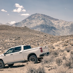
Good campsite, very remote. 2 wheels drive ok if not wet but some highly clearance might me required.
★
★
★
The end reward is the golden ring. Best way to see the Grand Canyon
★
★
★
★
★

You can see the Grand Canyon without going into the village - and paying the fee. It’s an easy route for most vehicles - I was in to 2WD the whole way there. On the way there you can stop and climb the Grandview lookout tower. After that you easily get to great viewpoints of the south rim. For anyone overlanding, this route has a ton of dry campsite opportunities.
★
★
★
★
★