Clawhammer Mountain via Middle Black Mountain
1.7 mi
Distance
50 min
Time
terrain
640 ft
Elev Gain
Rate this Hike
★★★★★
Public Tracks
Black Mountain
trail_hike_comments: This heavily-used trail features incredible views, hiking along a needle-sharp ridgeline, and lots of rock outcroppings and boulders. The trail itself is notable (unfortunately) for its heavily eroded sections. Either through erosion or work to repair it, which is ongoing, the trail is likely to change character as time goes on.
From the parking area just southeast of the Ranger Station on US 276, the trail begins on a gravel road and then veers left onto an old road bed ascending through Thrift Cove. Formerly lined with dark hemlocks, this cove features a tumbling stream and nice forest scenes filled with plenty of rhododendron.
The trail veers left again at the Thrift Cove trail intersection, becoming steeper as it climbs another old road bed. It crosses the creek a couple of times on ancient logging bridges, before pulling away from the creek to reach a switchback to the left. The trail ascends on a reroute that's in slightly better condition, and more like singletrack, up to the nose of the ridge, which it starts up directly. The forest here is mixed hardwoods.
The trail is highly eroded from here to the top of Hickory Knob - which is over 1400 ft. in elevation above the trailhead. It then descends about 240 ft. on a slightly less eroded stretch down to Pressley Gap and FS 5099 (Turkey Knob Rd.).
Continuing straight across the road, the trail ascends some steps and prepares to climb nearly 900 more feet over a heavily eroded stretch. The forest is typical of the ridglines in the area with mixed hardwoods and plenty of mountain laurel. Waterbars, roots, and a few rocks complete the seasoning of this stretch which is badly in need of repair. The difficulty tones down a bit past the Turkey Pen trail intersection as you move onto the top of the ridge and the shoulder of Black Mountain - the highpoint, at 4200 ft. elevation.
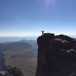
From here, the trail becomes less steep overall but has some ups and downs along the ridge. The trees are short and gnarled; the ridgeline between Black Mountain and Clawhammer Mountain is knife-sharp. This ridge divides the Davidson and Mills Rivers' watersheds. Great views open up in both directions, but especially to the southwest (a great place to stop for lunch). Past Clawhammer Mountain, the trail starts descending again over a rough course toward Buckhorn Gap. It switches back past a neat rock cave at one point. The descent to Buckhorn Gap is about 550 ft.
From Buckhorn Gap, the trail climbs again, starting on log stairs, past the Buckhorn Gap shelter and up Soapstone Ridge. The trail is less heavily traveled by this point. After cruising up and down along the summit ridge of Rich Mtn. for a stretch it descends to its end in Club Gap.
To the right is the Club Gap trail; straight is Buckwheat Knob trail; left is Avery Creek trail. These connections provide numerous loop options in either direction.
Formerly, the trail continued down what's now the Club Gap trail making it longer. I've seen the length of this trail listed anywhere from 9 to 16 miles, but my map data says more like 7 1/2. The 9.8mi value shown here is the official Forest Service number., trail_bike_comments: This heavily-used trail features incredible views, riding along a needle-sharp ridgeline, and lots of rock outcroppings and boulders. The trail itself is notable for its waterbars, switchbacks, and (unfortunately) heavily eroded sections. Either through erosion or work to repair it, which is ongoing, the trail is likely to change character as time goes on.
From the parking area just southeast of the Ranger Station on US 276, the trail begins on a gravel road and then veers left onto an old road bed ascending through Thrift Cove. Formerly lined with dark hemlocks, this cove features a tumbling stream and nice forest scenes filled with plenty of rhododendron.
The trail veers left again at the Thrift Cove trail intersection, becoming steeper as it climbs another old road bed. It crosses the creek a couple of times on ancient logging bridges, before pulling away from the creek to reach a switchback to the left. The trail ascends on a reroute that's in slightly better condition, and more like singletrack, up to the nose of the ridge, which it starts up directly. The forest here is mixed hardwoods.
The trail is highly eroded and technical from here to the top of Hickory Knob - which is over 1400 ft. of climbing from the trailhead. There are exposed roots, drop-offs, rocks, and broken waterbars all along the way. After a brief section of nice singletrack on top of Hickory Knob, the trail descends about 240 ft. on a slightly less eroded, but braided stretch down to Pressley Gap and FS 5099 (Turkey Knob Rd.).
Continuing straight across the road, the trail ascends some steps and prepares to climb nearly 900 more feet over a heavily eroded stretch, interspersed with some more decent sections of trail. The forest is typical of the ridglines in the area with mixed hardwoods and plenty of mount