North Fork Big Pine Creek Trail
8.9 mi
Distance
4 hrs 30 min
Time
terrain
2,287 ft
Elev Gain
Overview
This is a difficult out and back trail to Big Pine Creek Number 2 6-011 Dam in Inyo National Forest.
This trail goes by Cienega Mirth.
Sights to See
Rate this Hike
★★★★★

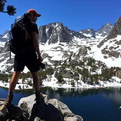
Solo day hiked Thurs 11/9/2023 – Hiked to Sam Mack Meadow using the North Fork Big Pine Creek & Palisade Glacier trails. Light snow and several icy trail sections to navigate on the North Fork while the Palisade was entirely covered with a nice layer of powdered snow with good grip. Felt like a winter hike with clear weather but a 19°F/-7°C cold morning at the meadow. Traversed the snow covered talus field at the meadow’s SW end and up the drainage chute towards Sam Mack Lake until my ice axe poked through a void/bridge. Couldn’t skirt the sides of the chute with its deep Bergschrund like crevasses next to the ridge walls so I traversed right to the class 3-4 ledges and ran into unclimbable ice on the rocks. Went further right and up the ledges to Sam Mack Lake which has its first layer of surface ice. Even with the warmth of the sun, winter is knocking on the door. Down and back to Fifth, Fourth and Black Lakes on beautiful loop trails on the way out with a stop at the Lon Chaney Cabin to cap off a great fall season in the Sierra. Was nice to see the spectacular fall colors and capitalize on an unusual number of clear weather days during the last half of this year. Logged 16.6 miles/4411 vertical ft. with Gaia ....................................................................................................................................................................................... Solo day hiked Fri 10/13/2023 – Early start up to the glacier after spending the night at Upper Sage Flat CG. Very scenic and gradual, steady climbing trail out to Sam Mack Meadow. Made a left turn at the trail sign in the meadow and went up the use trail to the base of the east lateral moraine. Took a southern most route up the moraine (climber’s left) to stay on the bigger boulders/talus and avoid the smaller scree slide sections which was pretty easy going (at least compared to the bishop pass side) and well cairned like others have said. From the top, you get an awesome view of the glacier and its proglacial lake while Starlight, North Palisade, Polemonium, Sill and Gayley tower above you. Headed down the other side of the moraine to the glacier and dropped off all my gear except for crampons/axe/helmet and climbed up southward to test the snow in the Glacier Notch chute from the storm 2 weeks ago and if the bergschrund was traversable. May want to wait a bit before going up Mt Sill and/or bring more equipment. The weather was once again perfect and the trek back was beautiful with stellar views of Buck Peak and Temple Crag in the background at each of the 3 lakes which were picturesque by themselves. Even with the creek flows still strong, all the water crossings were simple, especially if using poles as previously mentioned. Highly recommend this trail for a nice, long but beautiful hike. Logged 17.5 miles/4615 vertical ft. with Gaia
★
★
★
★
★


Public Tracks

Bishop Trail Run
Recorded on Garmin Enduro 3
https://connect.garmin.com/modern/activity/20471388629


 stars
stars