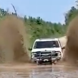
Water Gauge Road
4.0 mi
Distance
2 hrs 22 min
Time
terrain
579 ft
Elev Gain
Overview
This is a easy one way trail in Georgia.
Rate this Hike
★★★★★
Public Tracks

496
<b>Name: </b>WATERGAUGE<br /><b>Route Status: </b>EX - EXISTING<br /><b>Jurisdiction: </b>FS - FOREST SERVICE<br /><b>Operational Maintenance Level: </b>3 - SUITABLE FOR PASSENGER CARS<br /><b>Surface Type: </b>AGG - CRUSHED AGGREGATE OR GRAVEL<br /><b>System: </b>NFSR - NATIONAL FOREST SYSTEM ROAD<br /><b>Seasonal: </b>yearlong

WATERGAUGE
description: <br>ID: 511<br>NAME: WATERGAUGE<br>OPER_MAINT_LEVEL: 3 - SUITABLE FOR PASSENGER CARS<br>SURFACE_TYPE: AGG - CRUSHED AGGREGATE OR GRAVEL<br>Category: Open Forest Service Road<br>Dates_Allowed:
WATERGAUGE
Generated by http://open-mvum.com from data provided by USDA Forest Service. Please do not distribute.