meta

Tlaxcala Hike

based on 61 tracks & routes #1 hike out of 1 in
8.0 mi
Distance
2 hrs 59 min
Time
terrain
4,275 ft
Elev Gain

Overview

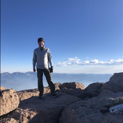
This is a difficult out and back trail in Tlaxcala.


    Rate this Hike

    user_profile
    7 years ago
    El camino hacia el volcán La Malinche está muy bien marcado y en buenas condiciones, casi 2/3 partes del recorrido es a través de bosque de pinos, recomendable llevar bastones de caminata
    ★ ★ ★ ★

    user_profile
    4 years, 11 months ago
    ★ ★ ★ ★ ★


Public Tracks

user_profile
HappyClover4968 1 year, 6 months ago
Ruta La Malinche
Comenzamos con 3039 msnm y al principio el sendero es fácil, aprox al Kilómetro 4 se hace más empinado, y así de puro bosque hasta llegar al arenal, tuvimos que rodear el arenal y subir por rocas. El paso es lento y constante para evitar caídas y el Mal de montaña. Al bajar fuimos por el Arenal para evitar caídas en las rocas.
user_profile
ToughShovel6081 1 week, 4 days ago
user_profile
Víctor Flores 2 weeks, 4 days ago
user_profile
LightWood3320 1 month, 2 weeks ago
user_profile
Sofía 2 months, 1 week ago
user_profile
Oscar 3 months, 1 week ago
user_profile
SlowBelay2791 9 months, 2 weeks ago
user_profile
BusyCreek3665 9 months, 2 weeks ago
user_profile
MintCamp1799 10 months, 1 week ago
user_profile
FreshHeather6541 11 months, 2 weeks ago
user_profile
BoldExplore2923 11 months, 2 weeks ago
user_profile
suahealyi 11 months, 3 weeks ago
user_profile
urijesai 1 year, 1 month ago
user_profile
cfis 1 year, 11 months ago
user_profile
Vegabond 3 years, 1 month ago
user_profile
RichShovel9711 3 years, 8 months ago
user_profile
pcunneen874 3 years, 9 months ago
user_profile
ChipperGaze2692 6 years ago
user_profile
Omar 6 years, 5 months ago
user_profile
jeffttan 7 years, 9 months ago

Elevation Profile

Seasonal Popularity