Canada
›
British Columbia
›
Borden Creek Forest Service Road

Borden Creek Forest Service Road(edit)

based on 13 tracks & routes   |   |  
DIFFICULT
  
DIFFICULT
link Copy Link email Email directions Driving Directions
  • GPX
  • KML

8.1 mi
Distance

3 hrs 39 min
Time
terrain
4,150 ft
Elev Gain

Overview

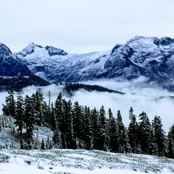
This is a moderate one way trail in British Columbia.


    Rate this Hike

    ★★★★★


Public Tracks

user_profile
Mike GoerZen 8 years, 4 months ago
Borden Creek Forest Service Road, Mount McGuire Trail, Chilliwack Lake Road

Elevation Profile

Seasonal Popularity

Nearby Hiking Trails

  1. Rapids Campground Loop
    ★ ★ ★ DIFFICULT 30.1 mi
  2. Rapids Campground Loop via Mount Thurston Forest Service Road
    ★ ★ ★ DIFFICULT 25.1 mi
  3. Chilliwack River via Mount Thurston Forest Service Road
    ★ ★ ★ DIFFICULT 18.8 mi
  4. Damfino Lakes via Canyon Ridge Trail
    ★ ★ ★ DIFFICULT 10.6 mi
  5. Chilliwack River via New Borden FSR
    ★ ★ ★ DIFFICULT 8.7 mi
  6. Pierce Lake Hiking Trail
    ★ ★ ★ DIFFICULT 3.5 mi
  7. Rapids Campground Loop via Mount Thurston Forest Service Road and Chipmunk Forest Service Road
    ★ ★ ★ DIFFICULT 20.6 mi
  8. Mount McGuire Trail and Borden Creek Forest Service Road
    ★ ★ ★ DIFFICULT 4.8 mi
  9. Tamihi Rapids Campground via Trans Canada Trail
    ★ ★ ★ EASY 4.2 mi
  10. Pierce Lake Hiking Trail
    ★ ★ ★ DIFFICULT 5.1 mi