Town Hwy 152
50.1 mi
Distance
30 hrs 25 min
Time
terrain
459 ft
Elev Gain
Overview
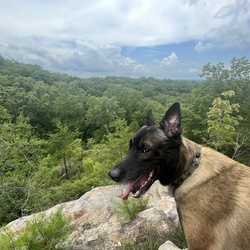
This is a difficult one way trail in Wayne National Forest - Ironton Unit.
Rate this Hike
★★★★★
Public Tracks

09-OakHill-to-Proctorville
Statistics computed from imported data<br><br>Distance: 49.9 miles<br>Minimum Elevation: 569 feet<br>Maximum Elevation: 800 feet<br>Total climb: 230 feet<br>Total descent: 181 feet

09-OakHill-to-Proctorville
Statistics computed from imported data<br><br>Distance: 49.9 miles<br>Minimum Elevation: 569 feet<br>Maximum Elevation: 800 feet<br>Total climb: 230 feet<br>Total descent: 181 feet

09-OakHill-to-Proctorville
Statistics computed from imported data<br><br>Distance: 49.9 miles<br>Minimum Elevation: 569 feet<br>Maximum Elevation: 800 feet<br>Total climb: 230 feet<br>Total descent: 181 feet