Mount Defiance
Overview
Mount Defiance, standing at 4,959 feet, is the highest point in the Columbia River Gorge. Known for its challenging terrain, this loop hike has become a popular training ground for mountaineers and trail runners. Starting at Starvation Creek State Park, hikers ascend relentlessly on the Mt. Defiance Trail, which was partly affected by the 2017 Eagle Creek Fire. The trail offers stunning views of Cascade and Gorge peaks from a talus slope. The descent follows the Mount Defiance Cutoff Trail, Mitchell Point Trail, and Starvation Ridge Trail, providing splendid vistas of the surrounding landscape.
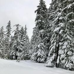
The hike begins at Starvation Creek State Park and takes hikers along the Historic Columbia River Highway State Trail, offering views of Shellrock Mountain, Wind Mountain, and Dog Mountain. Passing through shady maple woods, hikers can admire the restored section of the Historic Columbia River Highway, marked by dedicatory markers. Along the way, the trail leads to Cabin Creek Falls, a two-tiered waterfall with a unique hidden amphitheater. Continuing on the Mount Defiance Trail, hikers traverse a variety of landscapes, including powerline corridors, burned areas from the Eagle Creek Fire, and scenic talus slopes, with opportunities to spot wildlife and enjoy panoramic views.
After reaching the summit of Mount Defiance, hikers descend via the Mount Defiance Cutoff Trail, offering more scenic vistas of snow-capped Washington volcanoes. The trail then leads through a montane forest and a lengthy talus slope, providing views of Bear Lake and Mount Saint Helens. Hikers join the Mitchell Point Trail, passing by Warren Lake and exiting the wilderness area. The return portion of the loop follows the Starvation Ridge Trail, descending steeply through vine maple thickets and talus slopes, with impressive views of Mount Adams. The trail eventually leads back to Starvation Creek Trailhead, completing the challenging loop hike.
This loop hike to Mount Defiance is a demanding and rewarding adventure, attracting mountaineers and trail runners seeking a tough hiking challenge. With its breathtaking views, diverse landscapes, and opportunities to explore the Columbia River Gorge, this trail offers a memorable experience for outdoor enthusiasts.
Getting Started
From Portland, drive east on I-84 for more than 50 miles to Exit 55, signed for the Starvation Creek Trailhead and Historic Columbia River Highway State Trail.
There's no westbound exit to the Starvation Creek Rest Area, so drivers from the east (Hood River) will need to continue to Herman Creek Road and double back. Similarly, when leaving the rest area westbound drivers (Portland) will need to drive east on I-84 for about a mile and take the Viento exit, which leads to an underpass and then an I-84 on-ramp to Portland.
Be aware that the two primary hiking trails at this location (Starvation Ridge and Mt. Defiance) do not begin within the state park area by the restrooms and Starvation Creek Falls (walking east leads to Viento State Park along the historic highway), but instead require walking west, back alongside the freeway on the paved Historic Columbia River Highway State Trail. This route offers close approaches to Cabin Creek Falls and Hole in the Wall Falls. The Starvation Ridge Cutoff Trail also descends to this lower walk-in section.
Taking Children
This hike is really strenuous and long. I would recommend not taking children unless they are experienced.
Rate this Hike
★★★★★
 stars
stars