meta

合歡山 via 仁和路

based on 29 tracks & routes #40 hike out of 80 in
1.5 mi
Distance
40 min
Time
terrain
614 ft
Elev Gain

Overview

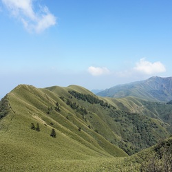
This is a easy out and back trail to 地圖解說牌 in 太魯閣國家公園.

This trail goes by 觀景台 and Hehuanshan.


    Rate this Hike

    user_profile
    1 year, 11 months ago


Public Tracks

user_profile
BoldLake7505 3 months, 1 week ago
user_profile
3 months, 3 weeks ago
user_profile
1 year, 1 month ago
user_profile
Ben Su 3 years, 11 months ago
user_profile
SnowyGale5447 4 years, 9 months ago
user_profile
RareCoast6908 4 years, 9 months ago
user_profile
MajorCoast8102 4 years, 10 months ago
user_profile
Wang Ming 5 years, 11 months ago
user_profile
陳貞蓁 6 years, 2 months ago
user_profile
SlowSail5855 6 years, 5 months ago
user_profile
Flora 6 years, 10 months ago