Council Crest from Marquam Shelter Loop
Overview
The described hike offers a good opportunity for decent elevation gain within Portland city limits, leading to Council Crest Park, which provides panoramic views on clear days. While Council Crest can be reached by car and has closer trailheads, following the described route offers a more challenging workout. The trail is mostly shaded under a leafy canopy dominated by maple, Douglas-fir, and hemlock trees.
The hike starts at the Marquam Nature Park Shelter Trailhead, where visitors can explore the interpretive panels and admire the Marquam Mosaic. From there, hikers head left and take the Shelter Trail, following the signs to Council Crest. The trail passes some old concrete house foundations and ascends through Marquam Gulch, surrounded by colorful big-leaf maples. After several switchbacks, hikers reach the junction with the Sunnyside Trail and continue left.
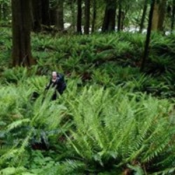
The trail continues through a diverse forest of Douglas-firs, cedars, hemlocks, and maples with an understory of Oregon grape and sword ferns. Hikers cross Fairmount Boulevard and reach a junction near the off-leash area at Council Crest Park. From there, they leave the Marquam Trail, pass through the off-leash area, and cross a road to reach the summit area of Council Crest.
At the summit, hikers can enjoy views of the Tualatin Valley, Chehalem Hills, downtown Portland, Vancouver, and Mount Hood to the east. The Washington stratovolcanoes, including Mount Saint Helens, Mount Rainier, and Mount Adams, are also visible to the north. On the return trip, hikers can make a loop by taking the Sunnyside Trail towards Marquam Gulch, descending back to the Marquam Nature Park Shelter.
The hike to Council Crest Park provides a challenging and scenic outdoor experience within the city, offering views of the surrounding landscapes and a glimpse into the area's natural beauty.
Getting Started
Drive south on Broadway and cross I-405. Veer left and turn right at the junction with 6th Avenue.
From this junction drive 0.3 miles (6th Avenue becomes Terwilliger Boulevard).
At the junction with Sam Jackson Park Road at Duniway Park, keep right and drive 0.2 miles.
Where Sam Jackson makes a sharp bend to the left uphill, turn right at the sign for Marquam Nature Park Shelter.
Sights to See
Rate this Hike
★★★★★


Public Tracks