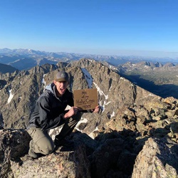
Mount of the Holy Cross
Overview
This is a difficult one way trail to Mount of the Holy Cross in White River National Forest.
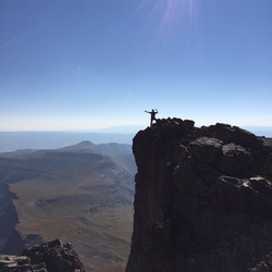
The elevation gain on this hike is about 5,600 feet. After attaining Half Moon Pass, there is a 1000 ft descent that must be climbed on the return trip making the total elevation gain significant, and making this hike difficult. It is a prettier hike than many other "14ers" passing through lots of forest with nice wilderness views, down to a creek at the foot of the descent, then continuing a short distance past camping spots for backpackers and overnighters to then turn upwards for a fairly steep hike to the summit. The last bit of vertical before attaining the summit is rocky and requires climbing over boulders to reach the summit (class 2). On the descent it is important to stay on the trail since many have gotten lost wandering too far west down the rocky slopes. It is more difficult to follow the trail thru the rocks, but it is there, at least once on the North ridge. When back to the canyon, ascend the 1000 feet to Half Moon Pass, then a short walk back to the trailhead.
As with all high peaks, pay attention to the weather and hike prepared for cooler temps and wind on the summit.
Getting Started
Tigiwon Road, south of Minturn is about 8 miles of fairly rough road but accessible to passenger cars to the Half Moon/Fall Creek trailhead, that accesses both the Mount of the Holy Cross and Notch Mountain trails. Expect to drive about one hour on this road.
Taking Children
I met a 10 year old Colorado girl at the summit of this mountain. So for hardy, hiking children this hike is doable, but probably not as a day hike.
Sights to See
Rate this Hike
★★★★★


Public Tracks