meta

McClellan Butte

based on 274 tracks & routes #1 hike out of 60 in
9.9 mi
Distance
4 hrs 31 min
Time
terrain
3,399 ft
Elev Gain

Overview

This trail is largely for those interested in heading up, steeply. Moderated with switchbacks at times, and with a gradual traverse when you need it, the rewards here are not without effort. The actual summit is a rock-scramble, but the views and the flower-packed west facing slope near the top can be enjoyed without making the true top. More than a few remaining old-growth trees and a soft tread make this a well-rounded hike whether it is a training hike or your weekend reward.

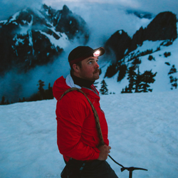
Do not attempt this in the winter without avalanche training! It is known for slides and is not a safe winter hike.

Getting Started

The first few miles crosses power lines, the Iron Horse Trail, and Forest Service road 9020. Stick with it and power up the at-times steep trail. Peek-a-boo views of the Alice Valley and Mount Kent to the east will keep you interested.

At roughly 2.5 miles into the hike one needs to exercise caution around a series of avalanche chutes and snow bridges which can be undermined by flowing water. These snow runnels can be quite dangerous and hard-packed with snow. At this elevation, snow frequently lasts until early July so be cautious and realistic with your abilities and equipment. If there is snow, come back when it is gone, since on these steep slopes, snow can slide at any time. The trail continues to about 4 miles, where it turns west and then quickly north towards the summit ridge.

This last mile of the hike has small meadows, a vernal pond, and scrambly little rocky sections of trail. Although most will be satisfied with the views from this area, the true summit may beckon to others. Those who venture up should keep in mind: rain can make the rock slippery and although technically easy the scramble to the summit is very exposed. Watch for the steps and hand holds blasted into the ridgeline.

Views from the top encompass the full range of I-90 peaks, Snoqualmie Pass, and much of the Alpine Lake Wilderness. As you carefully descend the rocky summit, think of the pioneers who first documented these lands. General George B McClellan visited this area in 1853 surveying (unsuccessfully) for a route for rail lines to pass through the Cascades. He chose the never-used Yakima Pass. The more popular route was Snoqualmie Pass, home now to the major interstate highway you used to get to the trailhead. Make sure to bring a NW Forest pass or America the Beautiful for parking

Taking Children

This is not a hike for children


Public Tracks

user_profile
Sente 8 years ago
McClellan Butte
This was our second hike on this trail.  The first time was in the spring and there was still lots of snow.  We thought that was what made it a hard hike.  Summer and no snow didn't make this one any easier.  In our opinion, this hike is harder than Mailbox.  Definitely a leg-burner. Bathrooms at the trailhead and there's lots of parking.  This hike tends to only have experienced hikers that know trail etiquette, which is nice.  It's well maintained and although you do have to do some walking on the John Wayne trail, it's not for long. At the end of the John Wayne trail there is a waterfall on the right.  We climbed down to enjoy it for a bit before starting the long trek up. Small glimpses of the surrounding mountains.  It was rather crowded at the peak so we sat just under it on a large flat rock for lunch.  This is an awesome trail to run down, until you hit the John Wayne trail again.
user_profile
Nicholas Heilweil 9 years, 7 months ago
Rob: McClellan Butte
This was our second hike on this trail.  The first time was in the spring and there was still lots of snow.  We thought that was what made it a hard hike.  Summer and no snow didn't make this one any easier.  In our opinion, this hike is harder than Mailbox.  Definitely a leg-burner. Bathrooms at the trailhead and there's lots of parking.  This hike tends to only have experienced hikers that know trail etiquette, which is nice.  It's well maintained and although you do have to do some walking on the John Wayne trail, it's not for long. At the end of the John Wayne trail there is a waterfall on the right.  We climbed down to enjoy it for a bit before starting the long trek up. Small glimpses of the surrounding mountains.  It was rather crowded at the peak so we sat just under it on a large flat rock for lunch.  This is an awesome trail to run down, until you hit the John Wayne trail again.
user_profile
robert.arora 9 years, 7 months ago
McClellan Butte
This was our second hike on this trail.  The first time was in the spring and there was still lots of snow.  We thought that was what made it a hard hike.  Summer and no snow didn't make this one any easier.  In our opinion, this hike is harder than Mailbox.  Definitely a leg-burner. Bathrooms at the trailhead and there's lots of parking.  This hike tends to only have experienced hikers that know trail etiquette, which is nice.  It's well maintained and although you do have to do some walking on the John Wayne trail, it's not for long. At the end of the John Wayne trail there is a waterfall on the right.  We climbed down to enjoy it for a bit before starting the long trek up. Small glimpses of the surrounding mountains.  It was rather crowded at the peak so we sat just under it on a large flat rock for lunch.  This is an awesome trail to run down, until you hit the John Wayne trail again.
user_profile
Nicholas Heilweil 10 years, 9 months ago
Rob: McClellan Butte
NOTE: 6.7 miles ONE WAY! GPS screwed up AGAIN! Crazy elevation hike - pretty similar to the OLD Si trail, but more elevation. The majority of UP is in a 3 mile section, making it steeper than Si as well. Snow-covered above 5000' in July. Didn't expect that... but the ice caves were cool. Definitely a leg-burner. Cramped quads near the end. Good running trail down, except for the scree (loose rock) section. Even though the guide books all say anywhere from 9-10 miles, I'm not sure where they got THAT idea. We had several GPS units with us and they all tagged it at 13.4 miles. Several hikers were asking "when does this end"... Gives you an idea of the difficulty (rated difficulty 5/5 at WTA).
user_profile
theresecoad 7 years, 8 months ago
20619 Tinkham Road Southeast, King County, WA, USA
What a spectacularly perfect day for a hike. It was very steep but absolutely beautiful. The view of mount rainier was one of the best!
user_profile
igray 2 years, 6 months ago
user_profile
Michael Strate 4 years, 9 months ago
user_profile
Bob_Lindskov 4 years, 10 months ago
user_profile
Matt 4 years, 10 months ago
user_profile
Taras 4 years, 10 months ago
user_profile
cfis 4 years, 10 months ago
user_profile
tjprescott 5 years, 5 months ago
user_profile
Marco 5 years, 7 months ago
user_profile
Marco 5 years, 7 months ago
user_profile
kavitakrishnan 5 years, 8 months ago
user_profile
kelseymscherer 5 years, 9 months ago
user_profile
kelseymscherer 5 years, 9 months ago
user_profile
mcdemax 5 years, 11 months ago
user_profile
Mary Swift 6 years, 8 months ago
user_profile
Brandon Copeland 7 years, 6 months ago
user_profile
Semilog 7 years, 7 months ago
user_profile
dancfuller 7 years, 7 months ago
user_profile
nlsiipola 7 years, 8 months ago
user_profile
angelatravels 7 years, 10 months ago
user_profile
robert.arora 7 years, 10 months ago
user_profile
Bobby 9 years, 10 months ago