Nesmith Point #428
Overview
This hike is a challenging climb often used by mountain climbers in training. It offers great views and is a good workout. The destination is an old lookout site on top of a red cinder cone of a Boring volcano, which was split in half by the Bretz Floods. The trail provides views of Cascade peaks, Gorge features in Washington, and passes through old-growth groves. It approaches the boundary of the Bull Run Watershed Management Area, which is off-limits to the public.
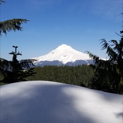
The hike starts at the John B Yeon State Park parking lot. The first mile of the trail is not too steep and was affected by the 2017 Eagle Creek Fire. The trail then rises to a switchback and traverses towards a rubble gully, offering views of Table Mountain and Greenleaf Peak. After switchbacks and basalt faces, Mount Adams comes into view. More switchbacks lead to clearer views of Beacon Rock, Hamilton Mountain, Silver Star Mountain, Mount Saint Helens, and Mount Rainier.
The trail passes Corky's Corner and continues uphill, offering views of Wauneka Ridge. It enters a woodland area of noble and silver fir that experienced a light ground fire. At the Nesmith Point Trail-Nesmith Point Road Junction, hikers turn right onto the road and hike to the old lookout site atop Nesmith Point volcano. From there, a small path leads to a great lookout with views of the entire gorge.
During winter and early spring, climbers should check snow levels and trail conditions as the upper part of the trail may be covered, requiring route-finding skills and good judgment.
Getting Started
From Portland:
Drive I-84 east to Exit 35 for the Historic Highway, Ainsworth State Park, Dodson, and Warrendale.
After 0.1 miles, turn left for Dodson, Warrendale, and Hood River.
In another 0.1 miles, make a right turn onto NE Frontage Road for Dodson.
Drive 2.1 miles on Frontage Road and then pull into parking on the right for John B. Yeon State Park.
From the east:
Take Exit 37, signed Warrendale. Head west on Warrendale Road for about 1/4 mile to a stop sign.
Turn left, go under the freeway, and turn left again onto Frontage Road.
Drive 1/4 mile east to the trailhead parking lot just before the road re-enters the highway.
Sights to See
Rate this Hike
★★★★★


Public Tracks