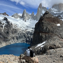
Rob Roy Glacier
6.2 mi
Distance
3 hrs 0 min
Time
terrain
1,301 ft
Elev Gain
Overview
This is a moderate one way trail to Rob Roy Glacier in Mount Aspiring National Park.
This trail goes by Lower Lookout.
Rate this Hike
★★★★★

Public Tracks

Rob Roy Track
<html><body><table border="1"><tr><th>Field Name</th><th>Field Value</th></tr><tr><td>TechObjectName</td><td>Rob Roy Track</td></tr><tr><td>FlocID</td><td>WMATUKIT-TK01</td></tr><tr><td>EquipmentID</td><td>Null</td></tr><tr><td>ObjectType</td><td>Track Visitor</td></tr><tr><td>ObjectTypeKey</td><td>FTBA-TRAVI</td></tr><tr><td>SubObjectType</td><td>Walking Track</td></tr><tr><td>SubObjectTypeKey</td><td>TRAVI-WATR</td></tr><tr><td>FlocCat</td><td>B</td></tr><tr><td>FlocCatStr</td><td>Tangible Built Assets</td></tr><tr><td>EquipCat</td><td>Null</td></tr><tr><td>EquipCatStr</td><td>Null</td></tr><tr><td>DataCaptureAccuracy</td><td>8</td></tr><tr><td>DataCaptureAccuracyStr</td><td>Automatically generated by script (default geometry)</td></tr><tr><td>GISStatus</td><td>Actioned</td></tr><tr><td>GISStatusStr</td><td>GIS Actioned</td></tr><tr><td>CharGlobalID</td><td>{1BD888D2-A818-4557-9919-156FAFEAA3D5}</td></tr><tr><td>CharName1</td><td>TECHNICAL_OBJECT_NAME</td></tr><tr><td>CharValue1</td><td>Rob Roy Track</td></tr><tr><td>CharName2</td><td>USER_STATUS</td></tr><tr><td>CharValue2</td><td>OPEN</td></tr><tr><td>CharName3</td><td>WEB_CATEGORY_TRACK</td></tr><tr><td>CharValue3</td><td>Walking track</td></tr><tr><td>CharName4</td><td>WEB_WALKING_DURATION</td></tr><tr><td>CharValue4</td><td>1-4 hours</td></tr><tr><td>CharName5</td><td>WEB_PERMITTED_ACTIVITIES</td></tr><tr><td>CharValue5</td><td>Null</td></tr><tr><td>CharName6</td><td>WEB_DOGS_ALLOWED</td></tr><tr><td>CharValue6</td><td>No Dogs</td></tr><tr><td>CharName7</td><td>WEB_TRACK_TYPE</td></tr><tr><td>CharValue7</td><td>Return via same track</td></tr><tr><td>CharName8</td><td>WEB_MTB_DURATION</td></tr><tr><td>CharValue8</td><td>Null</td></tr><tr><td>CharName9</td><td>WEB_MTB_CATEGORY</td></tr><tr><td>CharValue9</td><td>Null</td></tr><tr><td>CharName10</td><td>Null</td></tr><tr><td>CharValue10</td><td>Null</td></tr><tr><td>CharName11</td><td>Null</td></tr><tr><td>CharValue11</td><td>Null</td></tr><tr><td>SortField</td><td>100045434</td></tr><tr><td>Created_Date_Editor_Tracking</td><td>7/2/2022 6:59:10 PM</td></tr><tr><td>Last_Updated_Date_Editor_Track</td><td>7/2/2022 7:00:55 PM</td></tr><tr><td>GlobalID</td><td>{A953B92A-D130-425A-BDC6-2ECEFEF5DEB7}</td></tr><tr><td>Shape__Length</td><td>5400.506419</td></tr></table></body></html>

Hiking Rob Roy Glacier Trail
Distance: 6.7 miles<br>Duration: 2 hours, 55 minutes, and 33 seconds<br>Average Speed: 2.3 mph<br>Minimum Elevation: 1218 feet<br>Maximum Elevation: 2502 feet<br>Total climb: 1516 feet<br>Total descent: 1467 feet
Matukituki Valley Hike
https://connect.garmin.com/modern/activity/20992051681