Mount Baden-Powell via Pacific Crest Trail
Overview
This is a moderately difficult one way trail to Mount Baden-Powell in San Gabriel Mountains National Monument.
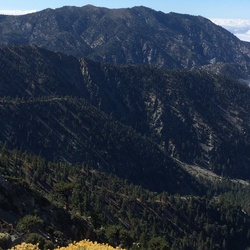
This is great training hike with awesome views of the desert to the north and many peaks of the San Gabriel and San Bernardino ranges. It's one of the standard training hikes for folks in spring. In winter, the trail itself can be covered in snow and ice with a high danger of avalanches on the steep slopes, so care and proper gear and training are needed. In addition, the road is often closed at Big Horn Mine road outside Wrightwood or at Grassy Hollow.
The trail winds up switchbacks through the trees for 2 miles with intermittant views of desert to the north. As you reach the top, the views expand to the east and west showing the whole range of the San Gabriels, Mt. Baldy, and finally, San Jacinto, San Gorgonio, and the Santa Ana Mountains to the south. The last part climbs up the narrow ridge to the large flat peak and the Baden-Powell Monument. Enjoy your well-earned rest at the top before retracing your steps back to the parking lot. Not enough miles? You can add the Big Horn Mine to bring your total distance over 10 miles for the day.
Getting Started
Access in good weather is easy. Drive Hwy 2 from either direction to the Vincent Gap Saddle and parking lot. The trailhead for Baden-Powell is at one end of the parking lot next to the trail to the Big Horn Mine. In winter, Hwy 2 is often closed at Big Horn Road or Grassy Hollow. Some do the hike from the Grassy Hollow, which is much longer. See the Caltrans quickmaps for Hwy 2 status; see the LA County web sites for Big Horn Mine status.
There is an alternative starting point further west on 2 at the Dollar Saddle which is longer and harder and, perhaps, very much worth the effort.
Taking Children
This hike is moderately graded, but straight up the hill on switchbacks. So, the route is easy, but the elevation gain, not so much.
Sights to See
Rate this Hike
★★★★★


Public Tracks


 stars
stars