Behind The Rocks Trail
14.1 mi
Distance
8 hrs 6 min
Time
terrain
1,255 ft
Elev Gain
Overview
This is a difficult one way trail in Behind The Rocks Wilderness Study Area.
Rate this Hike
★★★★★
Public Tracks

Behind The Rocks
Trail Length: 29 miles
Low-End Rating: 7
High-End Rating: 8
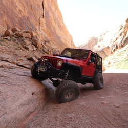
This is a very long and very challenging trail -- one of the most challenging trails in the Moab area. It features many technical obstacles and though you can avoid many of them the main one, White Knuckle Hill, is unavoidable. Be prepared to fully walk every obstacle before attempting it, follow your spotter, and be careful.
The trail starts just south of town on a dirt road. You aren't very far into it when you are treated to Guardian Hill, a very rocky, sandy and steep hill. If this hill gives you a lot of trouble then you should be prepared for a day filled with issues. It's a good test to see how you'll do on the rest of the trail.
The beginning of the trail is mainly sandy roads with a few rocks here and there, mixed with large ledges to travel up and down. A good portion of these ledges have bypasses.
At about 3.5 miles into the trail you'll come to a large, flat area. There are a few ways down the hill at the far end. To the left is a bypass (though not a particularly easy one) and to the right is High Dive.
High Dive is a very steep, very bumpy hill. There are a few lines down it and you should pick the best one for your vehicle and abilities. It is extremely challenging, but for an even greater thrill you can turn around at the bottom and go back up. A few people on a tow strap tied to your high end is recommended so you do not flip over.
At the bottom of High Dive and the bypass is Upchuck and yet another bypass. This gives you the opportunity to do High Dive but not Upchuck, or vice versa. Upchuck is a slick, steep hill with a significant crack in the middle that you should straddle as you climb it. Be careful not to slip in the crack or you may end up with body damage. Again, this hill might be safer if you have a tow strap attached to your high end and friends holding you down.
Turn left at the top of the hill past Upchuck and start down a sandy road where you can make up a lot of time. You'll find yourself heading toward Prostitute Butte (also known as Lone Rock) and you will eventually pass right next to it. There is a big, sandy area where you can park and look at Balcony Arch, the arch on this side of Prostitute Butte.
Take the road that circles around the Butte so you end up on the other side. There you can see Picture Frame Arch. You should climb to the arch to truly experience why they call it a Picture Frame. It is a difficult climb in spots but it is probably easiest if you climb from the left side of the arch.
After Picture Frame Arch, head down and away from the butte onto another sandy road. Follow signs to continue the trail.
The trail is fairly mellow for a bit, mostly sandy tracks mixed with low rocks. You'll come around a corner and find yourself at the base of Hummer Hill. This is one of the few slickrock domes on this trail and it is a steep one, though not particularly long. Drive straight up it or optionally around it to the left.
The trail gets very scenic and soon takes you left around a corner and you are at the top of Roller Coaster. This obstacle is two steep downhills of slickrock that is fairly smooth. It's a fun one to go up as well.
There are spurs along this section that allow you to escape the trail to avoid White Knuckle Hill. If you find yourself going down a narrow section of ledges then you are committed to going down the steep hill. You should definitely get out of your vehicle and walk this obstacle.
White Knuckle Hill consists of some ledges and big outcroppings of rock that you must drop down before completing the final part of the hill that is very nearly vertical and about ten feet tall. There are things you can do to make this hill safer, like stacking enough rocks at the bottom to make it more sloped there, and having a few friends hold a tow rope tied to the back of your vehicle as you go down. If you don't take any of these precautions, prepare for a little slide as you slip down the last part of the hill. When your tires touch the bottom you need to use the gas pedal to pull your front tires away from the hill so your rear end doesn't come over. Stacking a few rocks will make this much less urgent, though the hill is still very steep.
After the hill you'll make your way down to Hunters Canyon. This is the truly technical section of Behind The Rocks. There are a few areas of large rocks with big gaps between them that will make a stock or lightly modified vehicle really work hard.
Once you get through a few rocky areas you'll be at the bottom of the canyon. It is very lush down where the water is. There is an optional section at the bottom where you can really test the flexibility of your suspension. There is also an area where a large section of rock overhangs the trail.
There are signs to Pritchett Canyon and Pritchett Arch when you get to the end of the trail. Pritchett Arch is within walking distance from here so it is worth the side trip. To get back to town, follow the

Behind the Rocks 4.5
Behind the Rocks is one of the most challenging Jeep trails in the Moab area. Not counting Area BFE.

Behind the Rocks 4.5
Behind the Rocks is one of the most challenging Jeep trails in the Moab area. Not counting Area BFE.
Behind the Rocks 4.5
Behind the Rocks is one of the most challenging Jeep trails in the Moab area. Not counting Area BFE.

Behind the Rocks 4.5
Behind the Rocks is one of the most challenging Jeep trails in the Moab area. Not counting Area BFE.

Behind the Rocks 4.5
Behind the Rocks is one of the most challenging Jeep trails in the Moab area. Not counting Area BFE.

Behind the Rocks 4.5
Behind the Rocks is one of the most challenging Jeep trails in the Moab area. Not counting Area BFE.

Behind the Rocks 4.5
Behind the Rocks is one of the most challenging Jeep trails in the Moab area. Not counting Area BFE.
Behind the Rocks 4.5
Behind the Rocks is one of the most challenging Jeep trails in the Moab area. Not counting Area BFE.