meta

Thistledown Campground via County Road 361 and County Road 26

based on 71 tracks & routes #222 hike out of 273 in
6.9 mi
Distance
3 hrs 41 min
Time
terrain
2,877 ft
Elev Gain

Overview

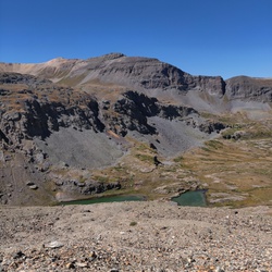
This is a difficult one way trail to Lower Bridge in Uncompahgre National Forest.

This trail goes by FR 869, Thistledown Campground, Angel Creek Campground, Kid's Wall, Cowboy Up, South Reservoir, Upper Bridge and Lead Area, Pic 'o the Vic, Trestle and Mixed Alcove, and School Room.


    Rate this Hike

    user_profile
    3 years, 7 months ago
    ★ ★ ★ ★ ★


Public Tracks

user_profile
ptellone 3 years, 7 months ago
user_profile
Drew.zeiser 3 years, 7 months ago
user_profile
SWAJetMech 4 years, 8 months ago
user_profile
Cruise 4 years, 9 months ago
user_profile
cmbtdoc2001 4 years, 9 months ago
user_profile
ethernectar 4 years, 10 months ago
user_profile
patton.copeland 4 years, 10 months ago
user_profile
lorencamp 5 years, 11 months ago