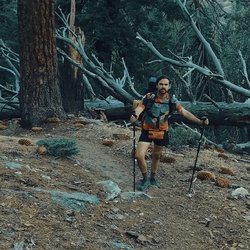
Solo hiked Thurs 5/2/2024 - It’s been many years since I’ve been on the Burkhart Trail and forgot how nice it is along Little Rock Creek, especially Cooper Canyon Falls which is flowing strongly right now. The upper part to Burkhart Saddle is another story as it recovers from the 2020 Bobcat fire and the 2023 Hilary storm. You get to see that things are recovering but with many decades to go. The upper scree slide and deadfall areas are best traversed with poles but not too bad like others have said. There is only one area on the trail where a thicket of Poodle Dog bush must be widely bypassed to avoid “paying the price.” Will Thrall, Pleasant View Ridge and Pallett Mtn peaks had great panoramic views, especially Antelope Valley to the north and the snow-capped San Gabriel’s (Baden-Powell, Throop, 3 Hawkins peaks) to the south. Going out to Box Car Ridge to visit the 1966 C-119 plane crash site was more for a solemn observation, given my prior time in aviation. I was very surprised to run into a few steep snowfield problems on the way to the Peak 7520 and Goodykoontz summits with hard snow and a little ice on the northern slopes of the Mt Williamson ridgeline. After trying to traverse the first without crampons or micros and a long runout, I opted to go further down the west-southwest drainage and then up on patchy snow which worked well. After Goodykoontz, I followed a west running ridge to Bobcat Knob and then headed south-southwest on a cross country trek which brought me directly down and back to the Little Rock Creek Log Crossing. From there it was back on the Burkhart Trail to Cooper Canyon Falls for a food break which was the most beautiful stop of the day. Got back in time to see a nice sunset from lower Angeles Crest to wrap up a nice day. Highly recommend the lower Burkhart Trail to the falls/Little Rock Creek and the upper part to those looking for the peaks. Logged 16.4 miles/5241 vertical ft with Gaia.
★
★
★
★
★
Hiked eastern half of this loop on 12/28/22 from Hwy 2 PCT junction closest to tunnels. Put on micro spikes for some of the steeper sloped, snow covered parts of the trail going up to the southeast summit of Mt Williamson. Some parts of the trail in the burn area were washed out by debris flows and then recently covered in snow. Once on Pleasant View Ridge, we had great packed powder snow conditions for the whole hike on a day of very clear but windy weather. We followed the ridgeline to the northeast summit of Mt. Williamson (official HPS peak) and then to the Pleasant View Ridge Summit east high point (8248 ft). Had to put on crampons to descend to the saddle before Peak 8160 and then continue climbing straight up the ridgeline up to its summit. Next was the steepest part of the hike, the straight line backbone descent of Peak 8160 towards Box Car Ridge where the snow held crampon points well, decreasing the chances of a long slide for life ride down either the partly iced NW face or the shaded NE chute. From here up to the summit of Pallet Mountain was back to boots only, very scenic hiking with spectacular views of the desert from the summit. Returned to the trailhead the same way at sunset with good snow, stopping at several great vista points. A great ridgeline hike with a little work required - tracked just under 11 miles and 3800 ft. Definitely want to come back for the western peaks on this trail before spring!
★
★
★
★
★

Great consistent gain from the creek wall the way to the saddle and then up to the peak
★
★
★
★